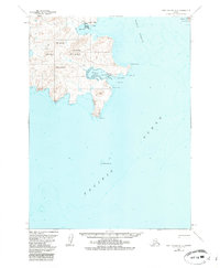
1963 Map of Port Moller A-2
USGS Topo · Published 1985About this map
Apollo Mine sits inland from the sheltered waters of Delarof Harbor, anchoring the industrial history of Unga Island in this coastal Alaskan survey. The island landscape is dominated by high points such as Apollo Mountain, Bloomer Peak, and Red Mountain, while the jagged coastline is punctuated by hazards like Elephant Rock and Halfway Rock. To the north, Squaw Harbor and a dedicated Seaplane Anchorage in Baralof Bay indicate the essential role of maritime and air transport for these remote outposts. Across the Popof Strait, the western edge of Popof Island is visible, including the prominent Popof Head. This map provides a detailed view of the terrain and nautical features within The Alaska Maritime National Wildlife Refuge, where isolation and rugged geography define the region's character.
Find a feature on this map
22 named features on this map. Tap any name to fly to it.
Don’t see what you’re looking for? This feature index may not catch every label — zoom into the map to look around manually.
Map Details
Editions of this 1963 Port Moller A-2 Map
3 editions found
Other maps of this area

1953 · Port Moller
USGS Topo · 1:250,000

1963 · Port Moller A-1
USGS Topo · 1:63,360

1963 · Port Moller A-2
USGS Topo · 1:63,360

1963 · Port Moller B-2
USGS Topo · 1:63,360

1963 · Port Moller B-1
USGS Topo · 1:63,360
1963 · Simeonof Island D-4
USGS Topo · 1:63,360
1963 · Port Moller A-3
USGS Topo · 1:63,360

1963 · Simeonof Island
USGS Topo · 1:250,000

1967 · Simeonof Island
USGS Topo · 1:250,000

1983 · Port Moller B-3
USGS Topo · 1:63,360