
1963 Map of Port Moller D-5
USGS Topo · Published 1985About this map
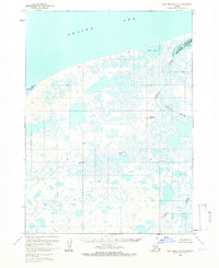
Bristol Bay defines the northern coastline of this remote Alaska Peninsula landscape, where a complex network of wetlands and tundra is documented during the early 1960s. The map illustrates a transitional environment where the Caribou Sapsuk River and David River wind through low-lying marshlands toward the coast. Significant topographical markers like Happys Hill break the otherwise level terrain, while coastal features such as Nelson Lagoon and Salt Water Lagoon indicate the region's tidally influenced geography. Evidence of human presence is sparse but distinct, shown through an isolated Landing Strip and a solitary Drill Hole, reflecting the mid-century's light industrial and transportation footprint in the Aleutians East region. The inclusion of hydrographic data from the early 1980s adds a layer of navigational detail to the shoreline near Coast Lake.
Find a feature on this map
15 named features on this map. Tap any name to fly to it.
Don’t see what you’re looking for? This feature index may not catch every label — zoom into the map to look around manually.
Map Details
Editions of this 1963 Port Moller D-5 Map
2 editions found
Historical Maps of Aleutians East Through Time
384 maps found

1944 Cold Bay Sheet No. 1 of 25
Aleutians East Borough, AK

1944 Cold Bay Sheet No. 20 of 25
Aleutians East Borough, AK

1944 Cold Bay Sheet No. 2 of 25
Aleutians East Borough, AK

1949 Fort Randall
Aleutians East Borough, AK

1950 Fort Randall
Aleutians East Borough, AK

1951 Unimak
Aleutians East Borough, AK

1953 Port Moller
Aleutians East Borough, AK

1955 Beechey Point B-5
Aleutians East Borough, AK

1958 Unimak
Aleutians East Borough, AK

1958 Unimak B-2 NE
Aleutians East Borough, AK

1963 Chignik A-6
Aleutians East Borough, AK

1963 Chignik A-7
Aleutians East Borough, AK

1963 Chignik A-8
Aleutians East Borough, AK

1963 Chignik B-7
Aleutians East Borough, AK

1963 Chignik C-5
Aleutians East Borough, AK

1963 Chignik C-6
Aleutians East Borough, AK

1963 Chignik D-4
Aleutians East Borough, AK

1963 Cold Bay B-3
Aleutians East Borough, AK

1963 Cold Bay B-4
Aleutians East Borough, AK

1963 Cold Bay C-1
Aleutians East Borough, AK

1963 Cold Bay C-2
Aleutians East Borough, AK

1963 Cold Bay D-1
Aleutians East Borough, AK

1963 False Pass C-1
Aleutians East Borough, AK

1963 False Pass C-2
Aleutians East Borough, AK

1963 False Pass D-0
Aleutians East Borough, AK

1963 False Pass D-1
Aleutians East Borough, AK

1963 False Pass D-2
Aleutians East Borough, AK

1963 False Pass D-3
Aleutians East Borough, AK

1963 Port Moller A-1
Aleutians East Borough, AK

1963 Port Moller A-2
Aleutians East Borough, AK

1963 Port Moller A-3
Aleutians East Borough, AK

1963 Port Moller A-4
Aleutians East Borough, AK

1963 Port Moller A-5
Aleutians East Borough, AK

1963 Port Moller A-6
Aleutians East Borough, AK

1963 Port Moller B-1
Aleutians East Borough, AK

1963 Port Moller B-2
Aleutians East Borough, AK

1963 Port Moller C-1
Aleutians East Borough, AK

1963 Port Moller C-2
Aleutians East Borough, AK

1963 Port Moller C-5
Aleutians East Borough, AK

1963 Port Moller C-6
Aleutians East Borough, AK

1963 Port Moller D-1
Aleutians East Borough, AK

1963 Port Moller D-2
Aleutians East Borough, AK

1963 Port Moller D-3
Aleutians East Borough, AK

1963 Port Moller D-4
Aleutians East Borough, AK
1963 Port Moller D-5
Aleutians East Borough, AK

1963 Port Moller D-6
Aleutians East Borough, AK

1963 Simeonof Island
Aleutians East Borough, AK

1963 Simeonof Island D-1
Aleutians East Borough, AK

1963 Simeonof Island D-2
Aleutians East Borough, AK

1963 Simeonof Island D-3
Aleutians East Borough, AK

1963 Simeonof Island D-4
Aleutians East Borough, AK

1963 Stepovak Bay A-5
Aleutians East Borough, AK

1963 Stepovak Bay A-6
Aleutians East Borough, AK

1963 Stepovak Bay B-6
Aleutians East Borough, AK

1963 Stepovak Bay C-5 and C-6
Aleutians East Borough, AK

1963 Stepovak Bay D-6
Aleutians East Borough, AK

1967 Simeonof Island
Aleutians East Borough, AK

1983 Cold Bay A-1
Aleutians East Borough, AK

1983 Cold Bay B-1
Aleutians East Borough, AK

1983 Port Moller B-3
Aleutians East Borough, AK

1983 Port Moller B-4
Aleutians East Borough, AK

1983 Port Moller B-5
Aleutians East Borough, AK

1983 Port Moller B-6
Aleutians East Borough, AK

1983 Port Moller C-3
Aleutians East Borough, AK

1983 Port Moller C-4
Aleutians East Borough, AK

1988 Port Moller
Aleutians East Borough, AK

1989 Cold Bay A-6
Aleutians East Borough, AK

1989 False Pass B-2
Aleutians East Borough, AK

1989 False Pass B-3
Aleutians East Borough, AK

1989 False Pass C-4
Aleutians East Borough, AK

1989 False Pass C-5
Aleutians East Borough, AK

1989 False Pass C-6
Aleutians East Borough, AK

1989 False Pass D-6
Aleutians East Borough, AK

1989 Unalaska D-1
Aleutians East Borough, AK

1989 Unimak A-3
Aleutians East Borough, AK

1989 Unimak A-4
Aleutians East Borough, AK

1989 Unimak A-5
Aleutians East Borough, AK

1989 Unimak A-6
Aleutians East Borough, AK

1989 Unimak B-2
Aleutians East Borough, AK

1989 Unimak B-3
Aleutians East Borough, AK

1989 Unimak B-5
Aleutians East Borough, AK

1989 Unimak B-6
Aleutians East Borough, AK

1989 Unimak C-1
Aleutians East Borough, AK

1989 Unimak C-2
Aleutians East Borough, AK

1989 Unimak C-3
Aleutians East Borough, AK

1989 Unimak D-1
Aleutians East Borough, AK

1989 Unimak D-2
Aleutians East Borough, AK

1995 Cold Bay A-2
Aleutians East Borough, AK

1995 Cold Bay A-3
Aleutians East Borough, AK

1995 Cold Bay A-4
Aleutians East Borough, AK

1995 Cold Bay A-5
Aleutians East Borough, AK

1995 Cold Bay B-2
Aleutians East Borough, AK

1995 False Pass D-4
Aleutians East Borough, AK

1995 False Pass D-5
Aleutians East Borough, AK

2017 Sitka A-1 NW
Aleutians East Borough, AK

2020 Chignik A-6 NW
Aleutians East Borough, AK

2020 Chignik A-6 SW
Aleutians East Borough, AK

2020 Chignik A-7 NE
Aleutians East Borough, AK

2020 Chignik A-7 NW
Aleutians East Borough, AK

2020 Chignik A-7 SE
Aleutians East Borough, AK

2020 Chignik A-7 SW
Aleutians East Borough, AK

2020 Chignik A-8 NE
Aleutians East Borough, AK

2020 Chignik A-8 SE
Aleutians East Borough, AK

2020 Chignik B-6 NW
Aleutians East Borough, AK

2020 Chignik B-6 SW
Aleutians East Borough, AK

2020 Chignik B-7 NE
Aleutians East Borough, AK

2020 Chignik B-7 NW
Aleutians East Borough, AK

2020 Chignik B-7 OE W SW
Aleutians East Borough, AK

2020 Chignik B-7 SE
Aleutians East Borough, AK

2020 Chignik B-7 SW
Aleutians East Borough, AK

2020 Chignik C-4 NW
Aleutians East Borough, AK

2020 Chignik C-5 NE
Aleutians East Borough, AK

2020 Chignik C-5 NW
Aleutians East Borough, AK

2020 Chignik C-6 SE
Aleutians East Borough, AK

2020 Chignik C-6 SW
Aleutians East Borough, AK

2020 Chignik D-4 SE
Aleutians East Borough, AK

2020 Chignik D-4 SW
Aleutians East Borough, AK

2020 Cold Bay A-1 NE
Aleutians East Borough, AK

2020 Cold Bay A-1 NW
Aleutians East Borough, AK

2020 Cold Bay A-1 SE
Aleutians East Borough, AK

2020 Cold Bay A-1 SW
Aleutians East Borough, AK

2020 Cold Bay A-2 NE
Aleutians East Borough, AK

2020 Cold Bay A-2 NW
Aleutians East Borough, AK

2020 Cold Bay A-2 SE
Aleutians East Borough, AK

2020 Cold Bay A-2 SW
Aleutians East Borough, AK

2020 Cold Bay A-3 NE
Aleutians East Borough, AK

2020 Cold Bay A-3 NW
Aleutians East Borough, AK

2020 Cold Bay A-3 SE
Aleutians East Borough, AK

2020 Cold Bay A-3 SW
Aleutians East Borough, AK

2020 Cold Bay A-4 NE
Aleutians East Borough, AK

2020 Cold Bay A-4 NW
Aleutians East Borough, AK

2020 Cold Bay A-4 SE
Aleutians East Borough, AK

2020 Cold Bay A-4 SW
Aleutians East Borough, AK

2020 Cold Bay A-5 SE
Aleutians East Borough, AK

2020 Cold Bay A-5 SW
Aleutians East Borough, AK

2020 Cold Bay A-6 SE
Aleutians East Borough, AK

2020 Cold Bay A-6 SW
Aleutians East Borough, AK

2020 Cold Bay B-1 NE
Aleutians East Borough, AK

2020 Cold Bay B-1 NW
Aleutians East Borough, AK

2020 Cold Bay B-1 SE
Aleutians East Borough, AK

2020 Cold Bay B-1 SW
Aleutians East Borough, AK

2020 Cold Bay B-2 NE
Aleutians East Borough, AK

2020 Cold Bay B-2 NW
Aleutians East Borough, AK

2020 Cold Bay B-2 SE
Aleutians East Borough, AK

2020 Cold Bay B-2 SW
Aleutians East Borough, AK

2020 Cold Bay B-3 NE
Aleutians East Borough, AK

2020 Cold Bay B-3 SE
Aleutians East Borough, AK

2020 Cold Bay B-3 SW
Aleutians East Borough, AK

2020 Cold Bay B-4 NE
Aleutians East Borough, AK

2020 Cold Bay B-4 NW
Aleutians East Borough, AK

2020 Cold Bay C-1 NE
Aleutians East Borough, AK

2020 Cold Bay C-1 NW
Aleutians East Borough, AK

2020 Cold Bay C-1 SE
Aleutians East Borough, AK

2020 Cold Bay C-1 SW
Aleutians East Borough, AK

2020 Cold Bay C-2 SE
Aleutians East Borough, AK

2020 Cold Bay D-1 SE
Aleutians East Borough, AK

2020 False Pass B-2 NE
Aleutians East Borough, AK

2020 False Pass B-2 NW
Aleutians East Borough, AK

2020 False Pass B-2 SE
Aleutians East Borough, AK

2020 False Pass B-2 SW
Aleutians East Borough, AK

2020 False Pass B-3 NE
Aleutians East Borough, AK

2020 False Pass B-3 NW
Aleutians East Borough, AK

2020 False Pass B-3 SE
Aleutians East Borough, AK

2020 False Pass B-3 SW
Aleutians East Borough, AK

2020 False Pass B-4 SE
Aleutians East Borough, AK

2020 False Pass C-1 NE
Aleutians East Borough, AK

2020 False Pass C-1 NW
Aleutians East Borough, AK

2020 False Pass C-1 SE
Aleutians East Borough, AK

2020 False Pass C-1 SW
Aleutians East Borough, AK

2020 False Pass C-2 NE
Aleutians East Borough, AK

2020 False Pass C-2 SE
Aleutians East Borough, AK

2020 False Pass C-3 NW
Aleutians East Borough, AK

2020 False Pass C-3 SE
Aleutians East Borough, AK

2020 False Pass C-3 SW
Aleutians East Borough, AK

2020 False Pass C-4 NE
Aleutians East Borough, AK

2020 False Pass C-4 NW
Aleutians East Borough, AK

2020 False Pass C-5 NE
Aleutians East Borough, AK

2020 False Pass C-5 NW
Aleutians East Borough, AK

2020 False Pass C-5 SE
Aleutians East Borough, AK

2020 False Pass C-5 SW
Aleutians East Borough, AK

2020 False Pass C-6 NE
Aleutians East Borough, AK

2020 False Pass C-6 NW
Aleutians East Borough, AK

2020 False Pass D-0 NE
Aleutians East Borough, AK

2020 False Pass D-0 NW
Aleutians East Borough, AK

2020 False Pass D-0 OE E NW
Aleutians East Borough, AK

2020 False Pass D-0 OE E SW
Aleutians East Borough, AK

2020 False Pass D-0 SE
Aleutians East Borough, AK

2020 False Pass D-0 SW
Aleutians East Borough, AK

2020 False Pass D-1 NE
Aleutians East Borough, AK

2020 False Pass D-1 NW
Aleutians East Borough, AK

2020 False Pass D-1 SE
Aleutians East Borough, AK

2020 False Pass D-1 SW
Aleutians East Borough, AK

2020 False Pass D-2 NE
Aleutians East Borough, AK

2020 False Pass D-2 NW
Aleutians East Borough, AK

2020 False Pass D-2 SE
Aleutians East Borough, AK

2020 False Pass D-2 SW
Aleutians East Borough, AK

2020 False Pass D-3 NE
Aleutians East Borough, AK

2020 False Pass D-3 NW
Aleutians East Borough, AK

2020 False Pass D-3 SE
Aleutians East Borough, AK

2020 False Pass D-4 NE
Aleutians East Borough, AK

2020 False Pass D-4 NW
Aleutians East Borough, AK

2020 False Pass D-4 SE
Aleutians East Borough, AK

2020 False Pass D-4 SW
Aleutians East Borough, AK

2020 False Pass D-5 NE
Aleutians East Borough, AK

2020 False Pass D-5 NW
Aleutians East Borough, AK

2020 False Pass D-5 SE
Aleutians East Borough, AK

2020 False Pass D-5 SW
Aleutians East Borough, AK

2020 False Pass D-6 NE
Aleutians East Borough, AK

2020 False Pass D-6 NW
Aleutians East Borough, AK

2020 False Pass D-6 SE
Aleutians East Borough, AK

2020 False Pass D-6 SW
Aleutians East Borough, AK

2020 Port Moller A-1 NE
Aleutians East Borough, AK

2020 Port Moller A-1 NW
Aleutians East Borough, AK

2020 Port Moller A-1 SE
Aleutians East Borough, AK

2020 Port Moller A-1 SW
Aleutians East Borough, AK

2020 Port Moller A-2 NE
Aleutians East Borough, AK

2020 Port Moller A-2 NW
Aleutians East Borough, AK

2020 Port Moller A-2 SW
Aleutians East Borough, AK

2020 Port Moller A-3 NE
Aleutians East Borough, AK

2020 Port Moller A-3 NW
Aleutians East Borough, AK

2020 Port Moller A-3 SE
Aleutians East Borough, AK

2020 Port Moller A-4 NE
Aleutians East Borough, AK

2020 Port Moller A-4 NW
Aleutians East Borough, AK

2020 Port Moller A-5 NE
Aleutians East Borough, AK

2020 Port Moller A-5 NW
Aleutians East Borough, AK

2020 Port Moller A-5 SE
Aleutians East Borough, AK

2020 Port Moller A-5 SW
Aleutians East Borough, AK

2020 Port Moller A-6 NE
Aleutians East Borough, AK

2020 Port Moller A-6 NW
Aleutians East Borough, AK

2020 Port Moller A-6 SE
Aleutians East Borough, AK

2020 Port Moller A-6 SW
Aleutians East Borough, AK

2020 Port Moller B-1 NE
Aleutians East Borough, AK

2020 Port Moller B-1 NW
Aleutians East Borough, AK

2020 Port Moller B-1 SE
Aleutians East Borough, AK

2020 Port Moller B-1 SW
Aleutians East Borough, AK

2020 Port Moller B-2 NE
Aleutians East Borough, AK

2020 Port Moller B-2 NW
Aleutians East Borough, AK

2020 Port Moller B-2 SE
Aleutians East Borough, AK

2020 Port Moller B-2 SW
Aleutians East Borough, AK

2020 Port Moller B-3 NE
Aleutians East Borough, AK

2020 Port Moller B-3 NW
Aleutians East Borough, AK

2020 Port Moller B-3 SE
Aleutians East Borough, AK

2020 Port Moller B-3 SW
Aleutians East Borough, AK

2020 Port Moller B-4 NE
Aleutians East Borough, AK

2020 Port Moller B-4 NW
Aleutians East Borough, AK

2020 Port Moller B-4 SE
Aleutians East Borough, AK

2020 Port Moller B-4 SW
Aleutians East Borough, AK

2020 Port Moller B-5 NE
Aleutians East Borough, AK

2020 Port Moller B-5 NW
Aleutians East Borough, AK

2020 Port Moller B-5 SE
Aleutians East Borough, AK

2020 Port Moller B-5 SW
Aleutians East Borough, AK

2020 Port Moller B-6 NE
Aleutians East Borough, AK

2020 Port Moller B-6 NW
Aleutians East Borough, AK

2020 Port Moller B-6 SE
Aleutians East Borough, AK

2020 Port Moller B-6 SW
Aleutians East Borough, AK

2020 Port Moller C-1 NE
Aleutians East Borough, AK

2020 Port Moller C-1 NW
Aleutians East Borough, AK

2020 Port Moller C-1 SE
Aleutians East Borough, AK

2020 Port Moller C-2 NE
Aleutians East Borough, AK

2020 Port Moller C-2 NW
Aleutians East Borough, AK

2020 Port Moller C-2 SE
Aleutians East Borough, AK

2020 Port Moller C-2 SW
Aleutians East Borough, AK

2020 Port Moller C-3 NE
Aleutians East Borough, AK

2020 Port Moller C-3 NW
Aleutians East Borough, AK

2020 Port Moller C-3 SE
Aleutians East Borough, AK

2020 Port Moller C-3 SW
Aleutians East Borough, AK

2020 Port Moller C-4 NE
Aleutians East Borough, AK

2020 Port Moller C-4 NW
Aleutians East Borough, AK

2020 Port Moller C-4 SE
Aleutians East Borough, AK

2020 Port Moller C-4 SW
Aleutians East Borough, AK

2020 Port Moller C-5 NE
Aleutians East Borough, AK

2020 Port Moller C-5 NW
Aleutians East Borough, AK

2020 Port Moller C-5 SE
Aleutians East Borough, AK

2020 Port Moller C-5 SW
Aleutians East Borough, AK

2020 Port Moller C-6 NE
Aleutians East Borough, AK

2020 Port Moller C-6 NW
Aleutians East Borough, AK

2020 Port Moller C-6 SE
Aleutians East Borough, AK

2020 Port Moller C-6 SW
Aleutians East Borough, AK

2020 Port Moller D-1 NE
Aleutians East Borough, AK

2020 Port Moller D-1 NW
Aleutians East Borough, AK

2020 Port Moller D-1 SE
Aleutians East Borough, AK

2020 Port Moller D-1 SW
Aleutians East Borough, AK

2020 Port Moller D-2 NE
Aleutians East Borough, AK

2020 Port Moller D-2 NW
Aleutians East Borough, AK

2020 Port Moller D-2 SE
Aleutians East Borough, AK

2020 Port Moller D-2 SW
Aleutians East Borough, AK

2020 Port Moller D-3 NE
Aleutians East Borough, AK

2020 Port Moller D-3 NW
Aleutians East Borough, AK

2020 Port Moller D-3 OE N SE
Aleutians East Borough, AK

2020 Port Moller D-3 OE N SW
Aleutians East Borough, AK

2020 Port Moller D-3 SE
Aleutians East Borough, AK

2020 Port Moller D-3 SW
Aleutians East Borough, AK

2020 Port Moller D-4 NE
Aleutians East Borough, AK

2020 Port Moller D-4 NW
Aleutians East Borough, AK

2020 Port Moller D-4 OE N SE
Aleutians East Borough, AK

2020 Port Moller D-4 OE N SW
Aleutians East Borough, AK

2020 Port Moller D-4 SE
Aleutians East Borough, AK

2020 Port Moller D-4 SW
Aleutians East Borough, AK

2020 Port Moller D-5 NE
Aleutians East Borough, AK

2020 Port Moller D-5 NW
Aleutians East Borough, AK

2020 Port Moller D-5 SE
Aleutians East Borough, AK

2020 Port Moller D-5 SW
Aleutians East Borough, AK

2020 Port Moller D-6 NE
Aleutians East Borough, AK

2020 Port Moller D-6 NW
Aleutians East Borough, AK

2020 Port Moller D-6 SE
Aleutians East Borough, AK

2020 Port Moller D-6 SW
Aleutians East Borough, AK

2020 Simeonof Island D-1 NW
Aleutians East Borough, AK

2020 Simeonof Island D-1 SW
Aleutians East Borough, AK

2020 Simeonof Island D-2 NE
Aleutians East Borough, AK

2020 Simeonof Island D-2 SW
Aleutians East Borough, AK

2020 Simeonof Island D-3 NW
Aleutians East Borough, AK

2020 Simeonof Island D-3 SE
Aleutians East Borough, AK

2020 Simeonof Island D-4 NE
Aleutians East Borough, AK

2020 Simeonof Island D-4 NW
Aleutians East Borough, AK

2020 Simeonof Island D-4 SW
Aleutians East Borough, AK

2020 Stepovak Bay A-5 NE
Aleutians East Borough, AK

2020 Stepovak Bay A-5 NW
Aleutians East Borough, AK

2020 Stepovak Bay A-5 OE E SW
Aleutians East Borough, AK

2020 Stepovak Bay A-5 OE N SW
Aleutians East Borough, AK

2020 Stepovak Bay A-5 SE
Aleutians East Borough, AK

2020 Stepovak Bay A-5 SW
Aleutians East Borough, AK

2020 Stepovak Bay A-6 NE
Aleutians East Borough, AK

2020 Stepovak Bay A-6 NW
Aleutians East Borough, AK

2020 Stepovak Bay A-6 SE
Aleutians East Borough, AK

2020 Stepovak Bay A-6 SW
Aleutians East Borough, AK

2020 Stepovak Bay B-6 SW
Aleutians East Borough, AK

2020 Stepovak Bay C-5 NW
Aleutians East Borough, AK

2020 Stepovak Bay C-5 SW
Aleutians East Borough, AK

2020 Stepovak Bay C-6 NE
Aleutians East Borough, AK

2020 Stepovak Bay C-6 SE
Aleutians East Borough, AK

2020 Stepovak Bay D-5 SW
Aleutians East Borough, AK

2020 Stepovak Bay D-6 NW
Aleutians East Borough, AK

2020 Stepovak Bay D-6 SE
Aleutians East Borough, AK

2020 Stepovak Bay D-6 SW
Aleutians East Borough, AK

2020 Unalaska C-1 NE
Aleutians East Borough, AK

2020 Unalaska D-1 NE
Aleutians East Borough, AK

2020 Unalaska D-1 SE
Aleutians East Borough, AK

2020 Unalaska D-1 SW
Aleutians East Borough, AK

2020 Unimak A-3 NE
Aleutians East Borough, AK

2020 Unimak A-3 SW
Aleutians East Borough, AK

2020 Unimak A-4 NE
Aleutians East Borough, AK

2020 Unimak A-4 NW
Aleutians East Borough, AK

2020 Unimak A-4 SE
Aleutians East Borough, AK

2020 Unimak A-4 SW
Aleutians East Borough, AK

2020 Unimak A-5 NE
Aleutians East Borough, AK

2020 Unimak A-5 NW
Aleutians East Borough, AK

2020 Unimak A-5 SE
Aleutians East Borough, AK

2020 Unimak A-5 SW
Aleutians East Borough, AK

2020 Unimak A-6 NE
Aleutians East Borough, AK

2020 Unimak A-6 NW
Aleutians East Borough, AK

2020 Unimak A-6 SE
Aleutians East Borough, AK

2020 Unimak A-6 SW
Aleutians East Borough, AK

2020 Unimak B-2 NW
Aleutians East Borough, AK

2020 Unimak B-2 OE E NW
Aleutians East Borough, AK

2020 Unimak B-5 SE
Aleutians East Borough, AK

2020 Unimak B-5 SW
Aleutians East Borough, AK

2020 Unimak B-6 SE
Aleutians East Borough, AK

2021 Sitka A-1 NW
Aleutians East Borough, AK

2021 Unimak A-3 NW
Aleutians East Borough, AK

2021 Unimak B-2 NE
Aleutians East Borough, AK

2021 Unimak B-3 NE
Aleutians East Borough, AK

2021 Unimak B-3 NW
Aleutians East Borough, AK

2021 Unimak C-1 NE
Aleutians East Borough, AK

2021 Unimak C-1 NW
Aleutians East Borough, AK

2021 Unimak C-1 SE
Aleutians East Borough, AK

2021 Unimak C-1 SW
Aleutians East Borough, AK

2021 Unimak C-2 NE
Aleutians East Borough, AK

2021 Unimak C-2 NW
Aleutians East Borough, AK

2021 Unimak C-2 SE
Aleutians East Borough, AK

2021 Unimak C-2 SW
Aleutians East Borough, AK

2021 Unimak C-3 NE
Aleutians East Borough, AK

2021 Unimak C-3 NW
Aleutians East Borough, AK

2021 Unimak C-3 SE
Aleutians East Borough, AK

2021 Unimak C-3 SW
Aleutians East Borough, AK

2021 Unimak D-1 NE
Aleutians East Borough, AK

2021 Unimak D-1 NW
Aleutians East Borough, AK

2021 Unimak D-1 SE
Aleutians East Borough, AK

2021 Unimak D-1 SW
Aleutians East Borough, AK

2021 Unimak D-2 NE
Aleutians East Borough, AK

2021 Unimak D-2 NW
Aleutians East Borough, AK

2021 Unimak D-2 SE
Aleutians East Borough, AK

2021 Unimak D-2 SW
Aleutians East Borough, AK

2023 Port Moller A-2 NW
Aleutians East Borough, AK

2024 Sitka A-1 NW
Aleutians East Borough, AK