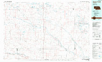
1985 Map of Goose Creek
USGS Topo · Published 1985This historical map portrays the area of Goose Creek in 1985, primarily covering Cherry County as well as portions of Hooker County, Thomas County, Blaine County, and Brown County. Featuring a scale of 1:100000, this map provides a highly detailed snapshot of the terrain, roads, buildings, counties, and historical landmarks in the Goose Creek region at the time. Published in 1985, it is one of 2 known editions of this map due to revisions or reprints.
Find a feature on this map
86 named features on this map. Tap any name to fly to it.
Don’t see what you’re looking for? This feature index may not catch every label — zoom into the map to look around manually.
Map Details
Editions of this 1985 Goose Creek Map
2 editions found
Historical Maps of Brown County Through Time
136 maps found

1948 Ashby
Cherry County, NE

1948 Seneca 4
Cherry County, NE

1948 Whitman
Cherry County, NE

1949 Ashby
Cherry County, NE

1949 Big Falls
Cherry County, NE

1949 Long Lake
Cherry County, NE

1949 Purdum
Cherry County, NE

1949 Seneca 4
Cherry County, NE

1949 Steverson Lake
Cherry County, NE

1949 Turpin Lake
Cherry County, NE

1950 Arabia
Cherry County, NE

1950 Doughboy
Cherry County, NE

1950 Hire
Cherry County, NE

1950 Irwin
Cherry County, NE

1950 Kennedy
Cherry County, NE

1950 Powderhorn Valley
Cherry County, NE

1950 Simeon
Cherry County, NE

1950 Sparks
Cherry County, NE

1950 Whitman
Cherry County, NE

1950 Wolf Lake
Cherry County, NE

1951 Big Falls
Cherry County, NE

1951 Bull Lake
Cherry County, NE

1951 Gypsy Valley
Cherry County, NE

1951 Irwin
Cherry County, NE

1951 Long Lake
Cherry County, NE

1951 Merriman 4
Cherry County, NE

1951 Purdum
Cherry County, NE

1951 Steverson Lake
Cherry County, NE

1951 Turpin Lake
Cherry County, NE

1951 Wolf Lake
Cherry County, NE

1952 Doughboy
Cherry County, NE

1952 Eli
Cherry County, NE

1969 Bovee Valley East
Cherry County, NE

1969 Coburn Canyon
Cherry County, NE

1969 Gordon SE
Cherry County, NE

1969 Hog Island
Cherry County, NE

1983 Cornell Dam
Cherry County, NE

1983 Crookston East
Cherry County, NE

1983 Muleshoe Creek
Cherry County, NE

1983 Sparks
Cherry County, NE

1983 Sparks SE
Cherry County, NE

1983 Thatcher
Cherry County, NE

1983 Valentine North
Cherry County, NE

1983 Valentine South
Cherry County, NE

1983 Valentine SW
Cherry County, NE

1985 Arabia
Cherry County, NE

1985 Arabia NW
Cherry County, NE

1985 Arabia SE
Cherry County, NE

1985 Arabia SW
Cherry County, NE

1985 Big Lake
Cherry County, NE

1985 Brownlee Flats
Cherry County, NE

1985 Brush Creek
Cherry County, NE

1985 Chesterfield Flats
Cherry County, NE

1985 Cody East
Cherry County, NE

1985 Cody SE
Cherry County, NE

1985 Cody West
Cherry County, NE

1985 Cooper Canyon
Cherry County, NE

1985 Crookston West
Cherry County, NE

1985 Eli
Cherry County, NE

1985 Eli SE
Cherry County, NE

1985 Eli SW
Cherry County, NE

1985 Ell Lake
Cherry County, NE

1985 Farm Flat
Cherry County, NE

1985 Goose Creek
Cherry County, NE

1985 Harr Valley
Cherry County, NE

1985 Heath Valley
Cherry County, NE

1985 Hudson Lake
Cherry County, NE

1985 Indian Hill
Cherry County, NE

1985 Kennedy
Cherry County, NE

1985 Kennedy NW
Cherry County, NE

1985 Kilgore SE
Cherry County, NE

1985 Long Lake
Cherry County, NE

1985 Long Lake SE
Cherry County, NE

1985 Long Lake SW
Cherry County, NE

1985 Medicine Lake
Cherry County, NE

1985 Mule Lake
Cherry County, NE

1985 Powderhorn Valley
Cherry County, NE

1985 Powderhorn Valley SW
Cherry County, NE

1985 Simeon
Cherry County, NE

1985 Skull Lake
Cherry County, NE

1985 Snake River Falls
Cherry County, NE

1985 Spring Canyon
Cherry County, NE

1985 Spring Lake
Cherry County, NE

1985 Willow Lake
Cherry County, NE

1985 Wilson Valley
Cherry County, NE

1985 Windmill Lake
Cherry County, NE

1986 Duck Lake
Cherry County, NE

1986 Duck Lake NE
Cherry County, NE

1986 Elsmere
Cherry County, NE

1986 Purdum NE
Cherry County, NE

1986 Purdum NW
Cherry County, NE

1987 Allen Valley
Cherry County, NE

1987 Big Falls
Cherry County, NE

1987 Brush Hill
Cherry County, NE

1987 Bull Lake
Cherry County, NE

1987 Carrico Lakes
Cherry County, NE

1987 Coleman Lake
Cherry County, NE

1987 Hire
Cherry County, NE

1987 Hire NE
Cherry County, NE

1987 Lowes Lake
Cherry County, NE

1987 Mayhew Lake
Cherry County, NE

1987 Mullen NE
Cherry County, NE

1987 Mullen NW
Cherry County, NE

1987 Rosebud Valley
Cherry County, NE

1987 Rose Valley
Cherry County, NE

1987 Round Lake
Cherry County, NE

1987 Sevenmile Hill
Cherry County, NE

1987 Square Lake
Cherry County, NE

1987 Steverson Lake
Cherry County, NE

1987 Sunflower Lake
Cherry County, NE

1987 White Willow Lake
Cherry County, NE

1987 Whitman NW
Cherry County, NE

1987 Wolf Lake
Cherry County, NE

1988 Barent Valley
Cherry County, NE

1988 Hill Lake
Cherry County, NE

1989 Bristol Lake
Cherry County, NE

1989 Camp Valley
Cherry County, NE

1989 Card Lake
Cherry County, NE

1989 Mother Lake
Cherry County, NE

1989 Turpin Lake East
Cherry County, NE

1989 Turpin Lake West
Cherry County, NE

1990 Bornemann Lake
Cherry County, NE

1990 Gypsy Valley
Cherry County, NE

1990 Irwin
Cherry County, NE

1990 Irwin SE
Cherry County, NE

1990 Irwin SW
Cherry County, NE

1990 Merriman NE
Cherry County, NE

1990 Merriman SE
Cherry County, NE

1990 Merriman SW
Cherry County, NE

1990 North Valley
Cherry County, NE

1990 Pole Creek Valley
Cherry County, NE

1990 Trumbull Lake
Cherry County, NE

1990 Wild Mare Lake
Cherry County, NE

1990 Wild Mare Lake NW
Cherry County, NE

1990 Wild Mare Lake SE
Cherry County, NE

1990 Wild Mare Lake SW
Cherry County, NE