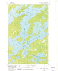
1981 Map of Basswood Lake East
USGS Topo · Published 1982This historical map portrays the area of Basswood Lake East in 1981, primarily covering Lake County. Featuring a scale of 1:24000, this map provides a highly detailed snapshot of the terrain, roads, buildings, counties, and historical landmarks in the Basswood Lake East region at the time. Published in 1982, it is one of 2 known editions of this map due to revisions or reprints.
Find a feature on this map
44 named features on this map. Tap any name to fly to it.
Don’t see what you’re looking for? This feature index may not catch every label — zoom into the map to look around manually.
Map Details
Editions of this 1981 Basswood Lake East Map
2 editions found
Historical Maps of Lake County Through Time
110 maps found

1953 Whyte
Lake County, MN

1954 Greenwood Lake
Lake County, MN

1955 Cramer
Lake County, MN

1955 Isabella
Lake County, MN

1956 Illgen City
Lake County, MN

1956 Little Marais
Lake County, MN

1956 Split Rock Point
Lake County, MN

1956 Split Rock Point NE
Lake County, MN

1957 Basswood Lake
Lake County, MN

1957 Castle Danger
Lake County, MN

1957 Ensign Lake
Lake County, MN

1957 Gabbro Lake
Lake County, MN

1957 Two Harbors NE
Lake County, MN

1959 Dutton Lake
Lake County, MN

1959 Ester Lake
Lake County, MN

1959 Kekekabic Lake
Lake County, MN

1959 Ogishkemuncie Lake
Lake County, MN

1960 Alice Lake
Lake County, MN

1960 Kawishiwi Lake
Lake County, MN

1960 Lake Polly
Lake County, MN

1960 Perent Lake
Lake County, MN

1976 Basswood Lake NW
Lake County, MN

1976 Basswood Lake SE
Lake County, MN

1976 Basswood Lake SW
Lake County, MN

1976 Ensign Lake SE
Lake County, MN

1976 Ensign Lake SW
Lake County, MN

1977 Basswood Lake
Lake County, MN

1981 Basswood Lake East
Lake County, MN

1981 Basswood Lake West
Lake County, MN

1981 Bogberry Lake
Lake County, MN

1981 Cramer
Lake County, MN

1981 Ensign Lake East
Lake County, MN

1981 Ensign Lake West
Lake County, MN

1981 Farm Lake
Lake County, MN

1981 Gabbro Lake
Lake County, MN

1981 Highland
Lake County, MN

1981 Isabella
Lake County, MN

1981 Isabella Lake
Lake County, MN

1981 Jackfish Lake
Lake County, MN

1981 Kane Lake
Lake County, MN

1981 Lake Insula
Lake County, MN

1981 Legler Lake
Lake County, MN

1981 Mitawan Lake
Lake County, MN

1981 Ojibway Lake
Lake County, MN

1981 Quadga Lake
Lake County, MN

1981 Sawbill Landing
Lake County, MN

1981 Silver Island Lake
Lake County, MN

1981 Slate Lake East
Lake County, MN

1981 Slate Lake West
Lake County, MN

1981 Snowbank Lake
Lake County, MN

1981 Wilson Lake
Lake County, MN

1982 Cabin Lake
Lake County, MN

1982 Cloquet Lake
Lake County, MN

1982 Doyle Lake
Lake County, MN

1982 Greenwood Lake East
Lake County, MN

1982 Greenwood Lake West
Lake County, MN

1982 Isabella Station
Lake County, MN

1982 Mt Weber
Lake County, MN

1982 Silver Bay SW
Lake County, MN

1982 Whyte
Lake County, MN

1992 Castle Danger
Lake County, MN

2022 Alice Lake
Lake County, MN

2022 Basswood Lake East
Lake County, MN

2022 Basswood Lake West
Lake County, MN

2022 Bogberry Lake
Lake County, MN

2022 Cabin Lake
Lake County, MN

2022 Castle Danger
Lake County, MN

2022 Cloquet Lake
Lake County, MN

2022 Cramer
Lake County, MN

2022 Doyle Lake
Lake County, MN

2022 Dutton Lake
Lake County, MN

2022 Ensign Lake East
Lake County, MN

2022 Ensign Lake West
Lake County, MN

2022 Ester Lake
Lake County, MN

2022 Farm Lake
Lake County, MN

2022 Gabbro Lake
Lake County, MN

2022 Greenwood Lake East
Lake County, MN

2022 Greenwood Lake West
Lake County, MN

2022 Highland
Lake County, MN

2022 Illgen City
Lake County, MN

2022 Isabella
Lake County, MN

2022 Isabella Lake
Lake County, MN

2022 Isabella Station
Lake County, MN

2022 Jackfish Lake
Lake County, MN

2022 Kane Lake
Lake County, MN

2022 Kawishiwi Lake
Lake County, MN

2022 Kekekabic Lake
Lake County, MN

2022 Lake Insula
Lake County, MN

2022 Lake Polly
Lake County, MN

2022 Legler Lake
Lake County, MN

2022 Little Marais
Lake County, MN

2022 Mitawan Lake
Lake County, MN

2022 Mount Weber
Lake County, MN

2022 Ogishkemuncie Lake
Lake County, MN

2022 Ojibway Lake
Lake County, MN

2022 Perent Lake
Lake County, MN

2022 Quadga Lake
Lake County, MN

2022 Sawbill Landing
Lake County, MN

2022 Silver Bay SW
Lake County, MN

2022 Silver Island Lake
Lake County, MN

2022 Slate Lake East
Lake County, MN

2022 Slate Lake West
Lake County, MN

2022 Snowbank Lake
Lake County, MN

2022 Split Rock Point
Lake County, MN

2022 Split Rock Point NE
Lake County, MN

2022 Split Rock Point OE S
Lake County, MN

2022 Two Harbors NE
Lake County, MN

2022 Two Harbors OE S
Lake County, MN

2022 Whyte
Lake County, MN

2022 Wilson Lake
Lake County, MN