
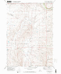
1970 Map of Granger Butte
USGS Topo · Published 1973About this map
Granger Butte dominates the central landscape of this Idaho interior, where the high basalt plateaus of Lava Flat and Bedrock Flat meet the drainage networks of the Little Weiser River. Photographed in 1969, the area reflects a remote ranching and grazing environment defined by isolated water sources like Bill George Spring and several unnamed Springs. The presence of a remote Landing Strip and multiple Corrals suggests the necessity of aerial and traditional livestock management across this expansive terrain. Waterways such as Hog Creek, Shirts Creek, and North Crane Creek carve through the plateaus, while the Boise Meridian serves as the primary longitudinal anchor for the township and range surveying system shown here.
Find a feature on this map
27 named features on this map. Tap any name to fly to it.
Don’t see what you’re looking for? This feature index may not catch every label — zoom into the map to look around manually.
Map Details
Editions of this 1970 Granger Butte Map
2 editions found
Other maps of this area

1894 · Squaw Creek
USGS Topo · 1:125,000

1897 · Weiser
USGS Topo · 1:125,000

1911 · Meadows
USGS Topo · 1:125,000

1954 · Council
USGS Topo · 1:62,500

1955 · Baker
USGS Topo · 1:250,000

1957 · Cambridge
USGS Topo · 1:62,500

1957 · Crane Creek Reservoir
USGS Topo · 1:62,500

1959 · Baker
USGS Topo · 1:250,000

1970 · Dodson Pass
USGS Topo · 1:24,000
1970 · Riley Butte
USGS Topo · 1:24,000