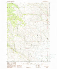
1987 Map of Hopper Creek
USGS Topo · Published 1987About this map
The H-I Mountains dominate this landscape, rising within the Payette National Forest during the late 1980s. This interior Idaho region is defined by a complex network of drainages and high ridges, where water sources like Looney Spring provide critical points of interest in the high country. The map traces the descent of numerous gulches and creeks, including Fairchild Gulch and Two Tree Gulch, as they feed into larger systems such as Hopper Creek. Toward the southern edge, the terrain levels slightly into the Shoe Peg Valley, where Keithly Creek and Dry Creek converge. The cartography reveals a remote landscape utilized for its timber and watershed value, captured here before modern digital updates changed the visual language of the forest service and topographic records.
Find a feature on this map
15 named features on this map. Tap any name to fly to it.
Don’t see what you’re looking for? This feature index may not catch every label — zoom into the map to look around manually.
Map Details
Editions of this 1987 Hopper Creek Map
This is the sole edition of this map. No revisions or reprints were ever made.
Other maps of this area

1897 · Weiser
USGS Topo · 1:125,000

1953 · Mann Creek
USGS Topo · 1:62,500

1955 · Baker
USGS Topo · 1:250,000

1957 · Cambridge
USGS Topo · 1:62,500

1957 · Crane Creek Reservoir
USGS Topo · 1:62,500

1957 · Sturgill Peak
USGS Topo · 1:62,500

1959 · Baker
USGS Topo · 1:250,000

1980 · McCall
USGS Topo · 1:100,000

1980 · Weiser
USGS Topo · 1:100,000
1986 · Midvale
USGS Topo · 1:24,000