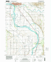
1998 Map of Weiser South
USGS Topo · Published 2002About this map
The Snake River serves as the dividing line between Idaho and Oregon in this late 20th-century topographic record, where the river's winding course creates landforms like Patch Island and Long Island. The city of Weiser anchors the northern portion of the sheet, while the surrounding landscape is dominated by the Oregon Slope and an extensive irrigation network featuring the Annex Canal and Galloway Canal.
Find a feature on this map
55 named features on this map. Tap any name to fly to it.
Don’t see what you’re looking for? This feature index may not catch every label — zoom into the map to look around manually.
Map Details
Editions of this 1998 Weiser South Map
This is the sole edition of this map. No revisions or reprints were ever made.
Other maps of this area

1897 · Weiser
USGS Topo · 1:125,000

1951 · Moores Hollow
USGS Topo · 1:24,000

1951 · Malheur Butte
USGS Topo · 1:24,000

1951 · Moores Hollow
USGS Topo · 1:62,500

1951 · Payette
USGS Topo · 1:24,000

1951 · Weiser South
USGS Topo · 1:24,000

1952 · Weiser Cove
USGS Topo · 1:24,000

1952 · Birding Island
USGS Topo · 1:24,000

1952 · Olds Ferry
USGS Topo · 1:62,500

1952 · Olds Ferry SE
USGS Topo · 1:24,000