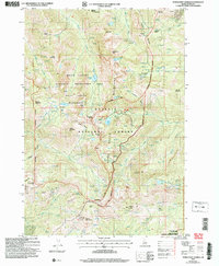
2004 Map of Purgatory Saddle
USGS Topo · Published 2007About this map
The Seven Devils Mountains dominate this region of Adams County, where the high-altitude terrain drops sharply into the depths of Hells Canyon. This 2004 revision reflects a landscape defined by its protection within the Payette National Forest and the Hells Canyon National Recreation Area. The map reveals a history of resource extraction and fire management, evidenced by numerous prospects, a shaft, and the Smith Mountain Lookout. Water features are abundant at these elevations, including Black Lake, Crystal Lake, and Ruth Lake, which feed the drainages of Granite Creek and the Middle Fork Rapid River. Historic movement through this difficult terrain is marked by the Horse Pasture Trail and landmarks like Purgatory Saddle and Stevens Saddle, illustrating the traditional routes used long before modern surveying.
Find a feature on this map
51 named features on this map. Tap any name to fly to it.
Don’t see what you’re looking for? This feature index may not catch every label — zoom into the map to look around manually.
Map Details
Editions of this 2004 Purgatory Saddle Map
This is the sole edition of this map. No revisions or reprints were ever made.
Other maps of this area

1920 · Seven Devils Mining District
USGS Topo · 1:48,000

1922 · He Devil
USGS Topo · 1:48,000

1938 · Riggins
USGS Topo · 1:96,000

1945 · Riggins
USGS Topo · 1:125,000

1955 · Grangeville
USGS Topo · 1:250,000

1957 · He Devil
USGS Topo · 1:62,500

1957 · Cuprum
USGS Topo · 1:62,500

1959 · Grangeville
USGS Topo · 1:250,000
1963 · Railroad Saddle
USGS Topo · 1:24,000
1963 · Pollock Mountain
USGS Topo · 1:24,000