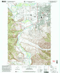
1999 Map of Southwest Missoula
USGS Topo · Published 2003About this map
The Bitterroot River and Clark Fork converge in this late 20th-century landscape, framing the southwestern expansion of Missoula. The map highlights a significant military and cultural footprint at Fort Missoula, where the Ft Missoula Historical Museum and Post Cem preserve the area's frontier-era legacy. Suburban development is evident in the residential clusters of Orchard Homes and the southern settlement of Lolo, contrasted against the steep rising slopes of the Lolo National Forest.
Find a feature on this map
66 named features on this map. Tap any name to fly to it.
Don’t see what you’re looking for? This feature index may not catch every label — zoom into the map to look around manually.
Map Details
Editions of this 1999 Southwest Missoula Map
This is the sole edition of this map. No revisions or reprints were ever made.
Other maps of this area

1903 · Bonner
USGS Topo · 1:125,000

1912 · Missoula
USGS Topo · 1:125,000

1947 · Butte
USGS Topo · 1:250,000

1956 · Hamilton
USGS Topo · 1:250,000

1958 · Butte
USGS Topo · 1:250,000

1959 · Hamilton
USGS Topo · 1:250,000

1959 · Cleveland Mountain
USGS Topo · 1:62,500

1960 · Butte
USGS Topo · 1:250,000

1960 · Hamilton
USGS Topo · 1:250,000

1962 · Butte
USGS Topo · 1:250,000