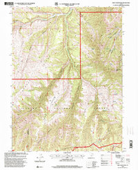
1996 Map of Gray Head Peak
USGS Topo · Published 2000About this map
Reservation Ridge and Fossil Ridge dominate this corner of the High Plateaus, marking a landscape defined by significant administrative boundaries and dramatic elevation. The western portion of the map is governed by the Ashley National Forest, while the southern reaches are contained within the Uintah and Ouray Indian Reservation. The boundary between Utah Co and Duchesne Co runs through the southwest, following the high ground. Numerous water sources like Olsen Spring, Sulphur Spring, and Trail Ridge Spring are scattered across the timbered slopes, supporting the network of canyons feeding into Avintaquin Creek. At the heart of the terrain, Gray Head Peak rises above the forks of the canyons, including Dry Fork Canyon and Right Fork Canyon. The topography here, with its pronounced benches like Wilbur Bench, reflects the geologic transition between the Wasatch and the Uinta Basin.
Find a feature on this map
34 named features on this map. Tap any name to fly to it.
Don’t see what you’re looking for? This feature index may not catch every label — zoom into the map to look around manually.
Map Details
Editions of this 1996 Gray Head Peak Map
This is the sole edition of this map. No revisions or reprints were ever made.
Other maps of this area

1885 · Uinta
USGS Topo · 1:250,000

1886 · Price River
USGS Topo · 1:250,000

1896 · Price River
USGS Topo · 1:250,000

1954 · Salt Lake City
USGS Topo · 1:250,000

1956 · Price
USGS Topo · 1:250,000

1958 · Salt Lake City
USGS Topo · 1:250,000

1960 · Salt Lake City
USGS Topo · 1:250,000

1960 · Price
USGS Topo · 1:250,000

1962 · Price
USGS Topo · 1:250,000
1962 · Sams Canyon
USGS Topo · 1:24,000