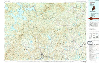
1994 Map of Rumford
USGS Topo · Published 1994About this map
The Mahoosuc Range and high peaks like Sugarloaf Mountain dominate this western Maine landscape, where the interconnected waters of Mooselookmeguntic Lake and Rangeley Lake define the northern territory. By the mid-1990s, the region's economy and recreation revolved around these water bodies and the established corridor of the Maine Central RR, which parallels the Androscoggin River through Rumford. Small settlements like Oquossoc and Mingo Springs reflect the area's long history as a destination for sportsman and seasonal residents.
Find a feature on this map
91 named features on this map. Tap any name to fly to it.
Don’t see what you’re looking for? This feature index may not catch every label — zoom into the map to look around manually.
Map Details
Editions of this 1994 Rumford Map
This is the sole edition of this map. No revisions or reprints were ever made.
Other maps of this area

1892 · Augusta
USGS Topo · 1:62,500

1893 · Gorham
USGS Topo · 1:62,500

1894 · Norridgewock
USGS Topo · 1:62,500

1896 · Gorham
USGS Topo · 1:62,500

1898 · Norridgewock
USGS Topo · 1:62,500

1903 · Bingham
USGS Topo · 1:62,500

1904 · Anson
USGS Topo · 1:62,500

1905 · Bingham
USGS Topo · 1:62,500

1910 · Livermore
USGS Topo · 1:62,500

1911 · Bryant Pond
USGS Topo · 1:62,500