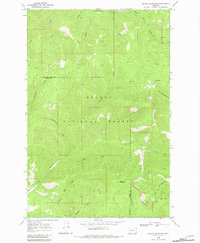
1968 Map of Nevada Mountain
USGS Topo · Published 1981About this map
Nevada Mountain stands as the central landmark of this high-elevation terrain within the Helena National Forest, where the Continental Divide zigzags along the boundary between Lewis and Clark and Powell counties. The landscape is defined by the headwaters of numerous drainages, including the west-flowing Nevada Creek and the eastern waters of South Fork Little Prickly Pear Cr. Mining activity and early transit routes are evident through the presence of the Cyclone Mine and unnamed mines tucked into drainages like Gleason Creek. Historical mobility through this portion of the Rockies is represented by the Gould Helmville Trail and various pack trails that negotiate the steep gulches and ridges. The naming of Shingle Mill Creek and Beartrap Gulch suggests the early industrial and survival practices that characterized this stretch of the Divide during the mid-20th century.
Find a feature on this map
25 named features on this map. Tap any name to fly to it.
Don’t see what you’re looking for? This feature index may not catch every label — zoom into the map to look around manually.
Map Details
Editions of this 1968 Nevada Mountain Map
3 editions found
Other maps of this area

1889 · Helena
USGS Topo · 1:250,000

1893 · Helena
USGS Topo · 1:250,000

1899 · Helena
USGS Topo · 1:250,000

1903 · Helena
USGS Topo · 1:250,000

1947 · Butte
USGS Topo · 1:250,000

1958 · Butte
USGS Topo · 1:250,000

1958 · Avon
USGS Topo · 1:62,500

1959 · Elliston
USGS Topo · 1:62,500

1960 · Butte
USGS Topo · 1:250,000

1962 · Butte
USGS Topo · 1:250,000