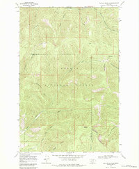
1968 Map of Nevada Mountain
USGS Topo · Published 1984About this map
The Continental Divide snake-like through this portion of the Helena National Forest, marking the boundary between the Missouri and Columbia River watersheds. At the center of this 1968 field-checked survey stands Nevada Mountain, a prominent high point surrounded by a network of drainage systems including Poorman Creek and Nevada Creek. The map documents a landscape defined by its extractive and transit history, featuring the Cyclone Mine near the headwaters of South Fork Poorman Creek. Transportation is largely restricted to the historic Gould Helmville Trail and various unnamed Jeep Trails, illustrating the area's isolation along the county line between Lewis and Clark and Powell Counties. Numerous gulches like Beartrap Gulch and Little Davis Gulch feed into the larger creek systems, while the presence of scattered mines indicates the persistent legacy of mineral exploration in these highlands.
Find a feature on this map
27 named features on this map. Tap any name to fly to it.
Don’t see what you’re looking for? This feature index may not catch every label — zoom into the map to look around manually.
Map Details
Editions of this 1968 Nevada Mountain Map
3 editions found
Other maps of this area

1889 · Helena
USGS Topo · 1:250,000

1893 · Helena
USGS Topo · 1:250,000

1899 · Helena
USGS Topo · 1:250,000

1903 · Helena
USGS Topo · 1:250,000

1947 · Butte
USGS Topo · 1:250,000

1958 · Butte
USGS Topo · 1:250,000

1958 · Avon
USGS Topo · 1:62,500

1959 · Elliston
USGS Topo · 1:62,500

1960 · Butte
USGS Topo · 1:250,000

1962 · Butte
USGS Topo · 1:250,000