
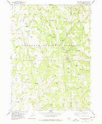
1978 Map of Hopper Gulch
USGS Topo · Published 1978About this map
The Sawtooth National Forest and the Minidoka National Forest State Bird Sanctuary dominate this portion of Idaho, characterized by a complex network of springs and drainage systems. Water sources are critical landmarks in this arid landscape, featuring named points such as Fourth of July Spring, Nelson Spring, and Soldier Spring. The terrain transitions into the Shoshone Basin to the south, where man-made infrastructure like a spillway and a Landing Strip indicate localized water management and remote accessibility. Traceable land use is evident through the scattered corrals, a Gravel Pit, and Alvins Well, reflecting the ranching and resource extraction needs of the era. The presence of numerous jeep trails underscores the remote nature of the Hopper Gulch area, providing a window into how these high-elevation forest and basin lands were navigated and utilized during the 1970s.
Find a feature on this map
36 named features on this map. Tap any name to fly to it.
Don’t see what you’re looking for? This feature index may not catch every label — zoom into the map to look around manually.
Map Details
Editions of this 1978 Hopper Gulch Map
This is the sole edition of this map. No revisions or reprints were ever made.
Other maps of this area

1955 · Twin Falls
USGS Topo · 1:250,000

1958 · Twin Falls
USGS Topo · 1:250,000

1965 · Hollister
USGS Topo · 1:24,000

1965 · Grand View Peak
USGS Topo · 1:24,000

1965 · Mc Mullen Basin
USGS Topo · 1:24,000

1977 · Timber Butte
USGS Topo · 1:24,000

1977 · Big Creek Ranch
USGS Topo · 1:24,000

1977 · Rogerson
USGS Topo · 1:24,000

1977 · Magic Hot Springs
USGS Topo · 1:24,000
1978 · Pike Mountain
USGS Topo · 1:24,000