
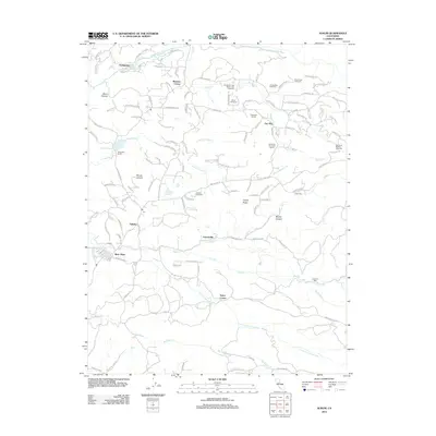
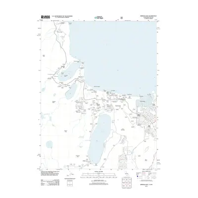
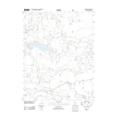
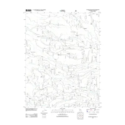
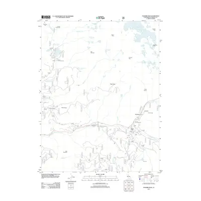
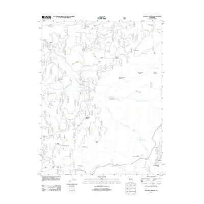
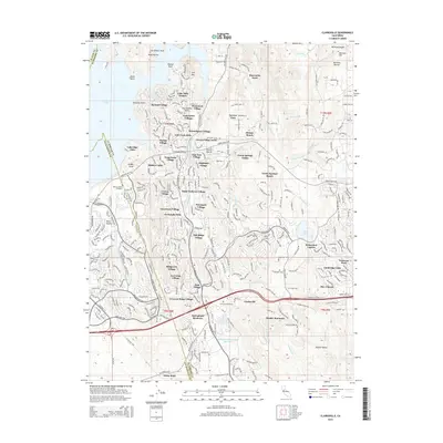
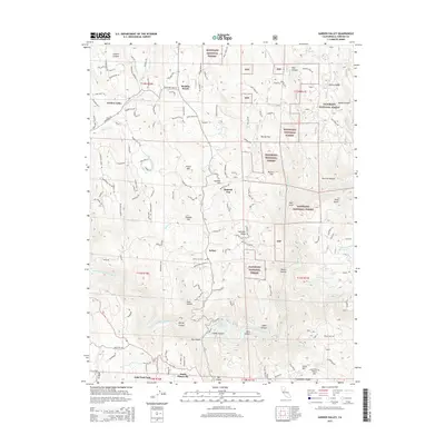
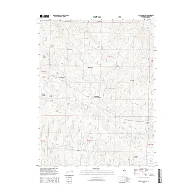
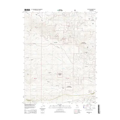
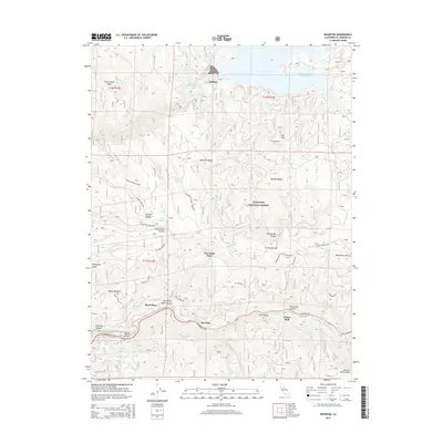
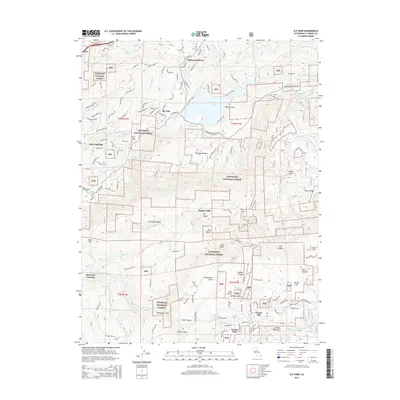
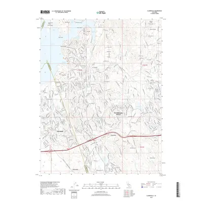
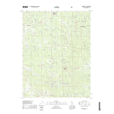
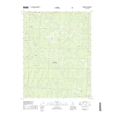
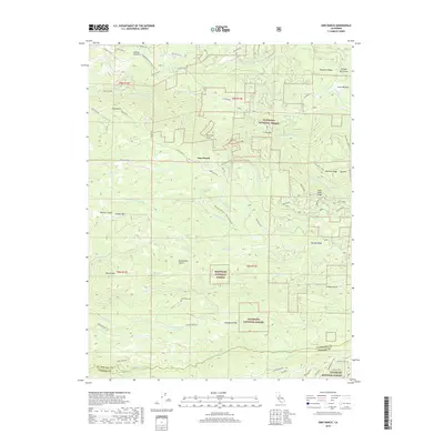
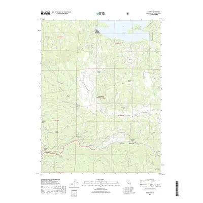
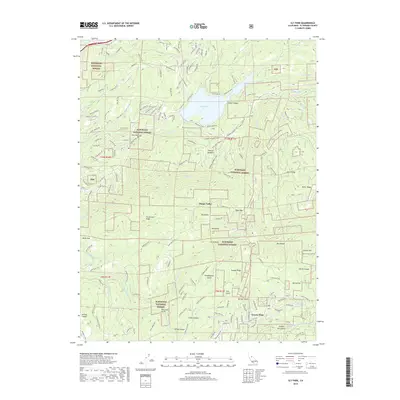
1992 Map of Rockbound Valley
USGS Topo · Published 1994About this map
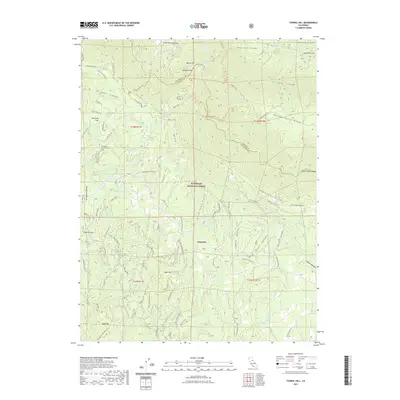
The Desolation Wilderness defines this high-elevation landscape, where the Rubicon River and its numerous glacial lakes dominate the granite basins of the Eldorado National Forest. By the early 1990s, this area was established as a premier backcountry destination, anchored by the Pacific Crest National Scenic Trail as it traverses the eastern ridge near Dicks Peak and Jacks Peak. The map captures a high-country economy focused on conservation and seasonal grazing, evidenced by the Univ of Calif Cow Camp located near the headwaters. Notable alpine features include the expansive Lake Aloha and the Rubicon Reservoir, which serves as a significant water management point. Long-established routes like the Rubicon Trail and General Creek Trail connect isolated flats such as Onion Flat and China Flat, providing a detailed look at the trail networks of the central Sierras.
Find a feature on this map
70 named features on this map. Tap any name to fly to it.
Don’t see what you’re looking for? This feature index may not catch every label — zoom into the map to look around manually.
Map Details
Editions of this 1992 Rockbound Valley Map
This is the sole edition of this map. No revisions or reprints were ever made.
Historical Maps of El Dorado County Through Time
146 maps found

1889 Pyramid Peak
El Dorado County, CA

1891 Pyramid Peak
El Dorado County, CA

1895 Pyramid Peak
El Dorado County, CA

1896 Pyramid Peak
El Dorado County, CA

1949 Garden Valley
El Dorado County, CA

1949 Greenwood
El Dorado County, CA

1949 Latrobe
El Dorado County, CA

1950 Garden Valley
El Dorado County, CA

1950 Greenwood
El Dorado County, CA

1950 Latrobe
El Dorado County, CA

1950 Riverton
El Dorado County, CA

1950 Robbs Peak
El Dorado County, CA

1950 Saddle Mountain
El Dorado County, CA

1950 Slate Mtn
El Dorado County, CA

1950 Tunnel Hill
El Dorado County, CA

1951 Caldor
El Dorado County, CA

1951 Leek Spring Hill
El Dorado County, CA

1951 Leek Spring Hill
El Dorado County, CA

1951 Old Iron Mountain
El Dorado County, CA

1951 Peddler Hill
El Dorado County, CA

1952 Aukum
El Dorado County, CA

1952 Kyburz
El Dorado County, CA

1952 Loon Lake
El Dorado County, CA

1952 Omo Ranch
El Dorado County, CA

1952 Robbs Peak
El Dorado County, CA

1952 Sly Park
El Dorado County, CA

1953 Clarksville
El Dorado County, CA

1953 Sly Park
El Dorado County, CA

1954 Pilot Hill
El Dorado County, CA

1955 Echo Lake
El Dorado County, CA

1955 Emerald Bay
El Dorado County, CA

1955 Fallen Leaf Lake
El Dorado County, CA

1955 Freel Peak
El Dorado County, CA

1955 Meeks Bay
El Dorado County, CA

1955 Pyramid Peak
El Dorado County, CA

1955 Rockbound Valley
El Dorado County, CA

1979 Tragedy Spring
El Dorado County, CA

1992 Echo Lake
El Dorado County, CA

1992 Emerald Bay
El Dorado County, CA

1992 Freel Peak
El Dorado County, CA

1992 Meeks Bay
El Dorado County, CA

1992 Pyramid Peak
El Dorado County, CA
1992 Rockbound Valley
El Dorado County, CA

1992 Tragedy Spring
El Dorado County, CA
2012 Aukum
El Dorado County, CA
2012 Caldor
El Dorado County, CA
2012 Clarksville
El Dorado County, CA
2012 Echo Lake
El Dorado County, CA
2012 Emerald Bay
El Dorado County, CA
2012 Freel Peak
El Dorado County, CA
2012 Garden Valley
El Dorado County, CA
2012 Greenwood
El Dorado County, CA
2012 Kyburz
El Dorado County, CA

2012 Latrobe
El Dorado County, CA
2012 Leek Spring Hill
El Dorado County, CA
2012 Loon Lake
El Dorado County, CA
2012 Meeks Bay
El Dorado County, CA
2012 Old Iron Mountain
El Dorado County, CA
2012 Omo Ranch
El Dorado County, CA
2012 Peddler Hill
El Dorado County, CA
2012 Pilot Hill
El Dorado County, CA
2012 Pyramid Peak
El Dorado County, CA

2012 Riverton
El Dorado County, CA

2012 Robbs Peak
El Dorado County, CA
2012 Rockbound Valley
El Dorado County, CA
2012 Slate Mountain
El Dorado County, CA
2012 Sly Park
El Dorado County, CA
2012 Tragedy Spring
El Dorado County, CA
2012 Tunnel Hill
El Dorado County, CA
2015 Aukum
El Dorado County, CA
2015 Caldor
El Dorado County, CA
2015 Clarksville
El Dorado County, CA
2015 Echo Lake
El Dorado County, CA
2015 Emerald Bay
El Dorado County, CA
2015 Freel Peak
El Dorado County, CA
2015 Garden Valley
El Dorado County, CA
2015 Greenwood
El Dorado County, CA
2015 Kyburz
El Dorado County, CA
2015 Latrobe
El Dorado County, CA
2015 Leek Spring Hill
El Dorado County, CA
2015 Loon Lake
El Dorado County, CA
2015 Meeks Bay
El Dorado County, CA
2015 Old Iron Mountain
El Dorado County, CA
2015 Omo Ranch
El Dorado County, CA
2015 Peddler Hill
El Dorado County, CA
2015 Pilot Hill
El Dorado County, CA
2015 Pyramid Peak
El Dorado County, CA
2015 Riverton
El Dorado County, CA
2015 Robbs Peak
El Dorado County, CA
2015 Rockbound Valley
El Dorado County, CA
2015 Slate Mountain
El Dorado County, CA
2015 Sly Park
El Dorado County, CA
2015 Tragedy Spring
El Dorado County, CA
2015 Tunnel Hill
El Dorado County, CA
2018 Aukum
El Dorado County, CA

2018 Caldor
El Dorado County, CA
2018 Clarksville
El Dorado County, CA
2018 Echo Lake
El Dorado County, CA
2018 Emerald Bay
El Dorado County, CA
2018 Freel Peak
El Dorado County, CA
2018 Garden Valley
El Dorado County, CA
2018 Greenwood
El Dorado County, CA
2018 Kyburz
El Dorado County, CA
2018 Latrobe
El Dorado County, CA
2018 Leek Spring Hill
El Dorado County, CA
2018 Loon Lake
El Dorado County, CA
2018 Meeks Bay
El Dorado County, CA
2018 Old Iron Mountain
El Dorado County, CA
2018 Omo Ranch
El Dorado County, CA
2018 Peddler Hill
El Dorado County, CA
2018 Pilot Hill
El Dorado County, CA
2018 Pyramid Peak
El Dorado County, CA
2018 Riverton
El Dorado County, CA
2018 Robbs Peak
El Dorado County, CA
2018 Rockbound Valley
El Dorado County, CA
2018 Slate Mountain
El Dorado County, CA
2018 Sly Park
El Dorado County, CA
2018 Tragedy Spring
El Dorado County, CA
2018 Tunnel Hill
El Dorado County, CA

2021 Aukum
El Dorado County, CA

2021 Caldor
El Dorado County, CA

2021 Clarksville
El Dorado County, CA

2021 Echo Lake
El Dorado County, CA

2021 Emerald Bay
El Dorado County, CA

2021 Garden Valley
El Dorado County, CA
2021 Greenwood
El Dorado County, CA

2021 Kyburz
El Dorado County, CA

2021 Latrobe
El Dorado County, CA

2021 Leek Spring Hill
El Dorado County, CA

2021 Loon Lake
El Dorado County, CA

2021 Meeks Bay
El Dorado County, CA

2021 Old Iron Mountain
El Dorado County, CA

2021 Omo Ranch
El Dorado County, CA

2021 Peddler Hill
El Dorado County, CA

2021 Pyramid Peak
El Dorado County, CA

2021 Riverton
El Dorado County, CA

2021 Robbs Peak
El Dorado County, CA

2021 Rockbound Valley
El Dorado County, CA

2021 Slate Mountain
El Dorado County, CA

2021 Sly Park
El Dorado County, CA

2021 Tragedy Spring
El Dorado County, CA
2021 Tunnel Hill
El Dorado County, CA

2022 Freel Peak
El Dorado County, CA

2022 Pilot Hill
El Dorado County, CA

2023 Greenwood
El Dorado County, CA

2023 Tunnel Hill
El Dorado County, CA