
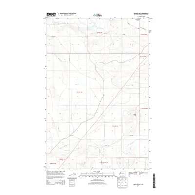
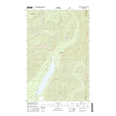
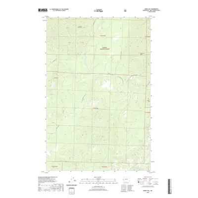
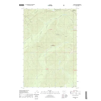
1990 Map of Burnt Hill
USGS Topo · Published 1990About this map
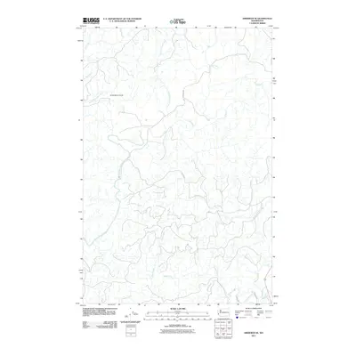
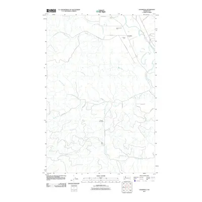
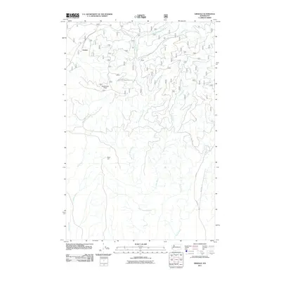
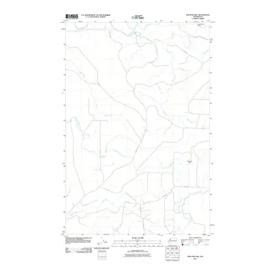
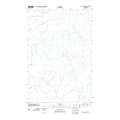
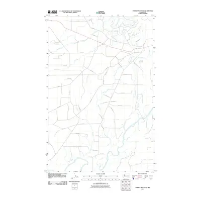
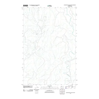
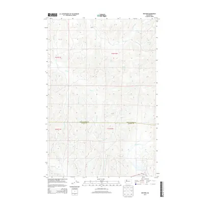
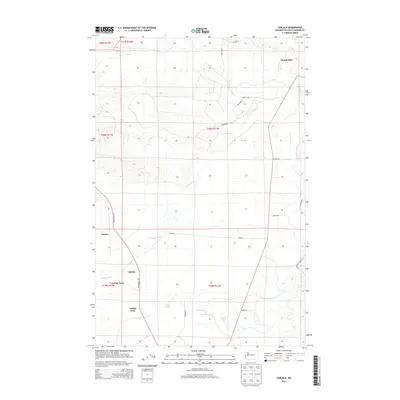
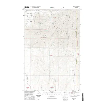
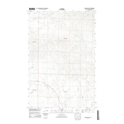
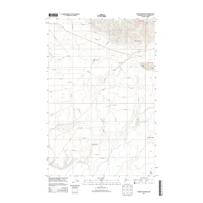
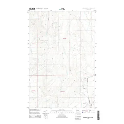
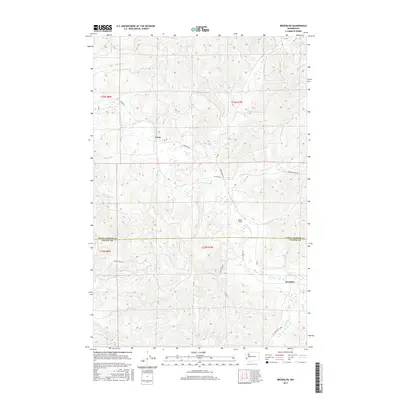
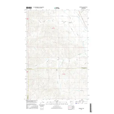
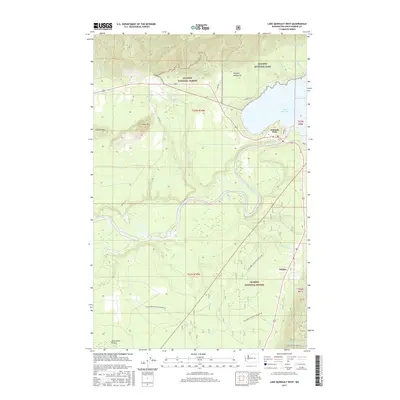
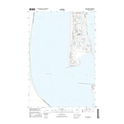
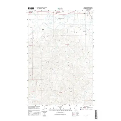
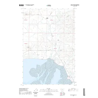
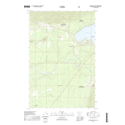
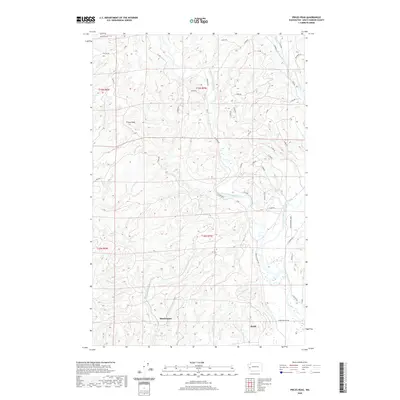
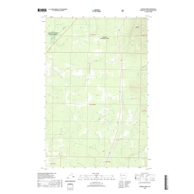
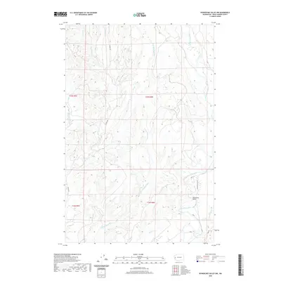
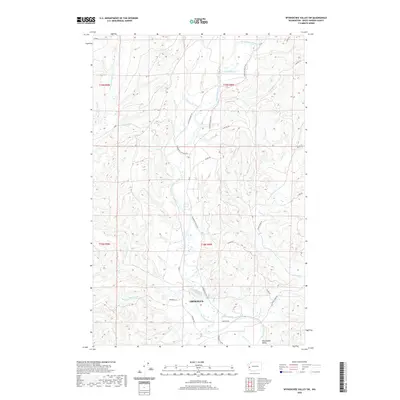
Olympic National Forest land dominates this 1990 provisional study, revealing the complex drainage network of the Humptulips River and its major tributaries. The landscape is defined by the steep relief of Burnt Hill and Cougar Mountain, where the West Fork Humptulips River carves a winding path through the timberlands. Cultural markers are sparse but significant for tracing historical land use, including the Humptulips FS Station and several industrial features such as a Borrow Pit and an old Railroad Grade. These elements reflect a period of intensive forest management and resource extraction in Grays Harbor County. Smaller waterways like Donkey Creek and O'Brien Creek feed into the larger river systems, illustrating the hydrological patterns that have shaped the development of this Pacific Northwest timber region.
Find a feature on this map
28 named features on this map. Tap any name to fly to it.
Don’t see what you’re looking for? This feature index may not catch every label — zoom into the map to look around manually.
Map Details
Editions of this 1990 Burnt Hill Map
This is the sole edition of this map. No revisions or reprints were ever made.
Historical Maps of Grays Harbor County Through Time
192 maps found

1921 Quinault Lake
Grays Harbor County, WA

1941 Ford
Grays Harbor County, WA

1941 Mobray
Grays Harbor County, WA

1943 Mobray
Grays Harbor County, WA

1955 Aberdeen SE
Grays Harbor County, WA

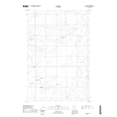
1955 Carlisle
Grays Harbor County, WA

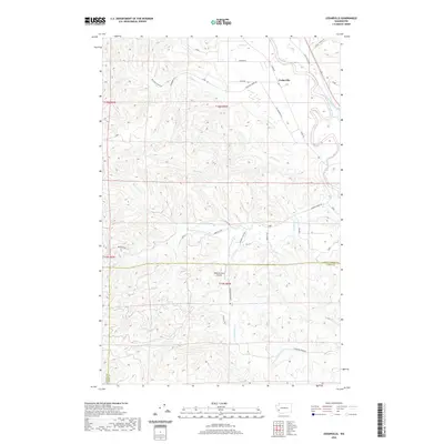
1955 Grisdale
Grays Harbor County, WA

1955 Macafee Hill
Grays Harbor County, WA

1955 Point Brown
Grays Harbor County, WA

1955 Quinault Lake
Grays Harbor County, WA

1955 Wynoochee Valley
Grays Harbor County, WA

1956 Copalis Crossing
Grays Harbor County, WA

1956 Western
Grays Harbor County, WA

1981 Mc Cleary
Grays Harbor County, WA

1982 Macafee Hill
Grays Harbor County, WA

1982 Shale Slough
Grays Harbor County, WA

1982 Tunnel Island
Grays Harbor County, WA

1986 Blue Mountain
Grays Harbor County, WA

1986 Brooklyn
Grays Harbor County, WA

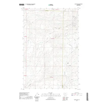
1986 Capitol Peak
Grays Harbor County, WA

1986 Cedarville
Grays Harbor County, WA

1986 Elkhorn Creek
Grays Harbor County, WA

1986 South Elma
Grays Harbor County, WA
1990 Burnt Hill
Grays Harbor County, WA

1990 Colonel Bob
Grays Harbor County, WA

1990 Grisdale
Grays Harbor County, WA

1990 Lake Quinault East
Grays Harbor County, WA

1990 Lake Quinault West
Grays Harbor County, WA

1990 Larsen Creek
Grays Harbor County, WA

1990 New London
Grays Harbor County, WA

1990 O'Took Prairie
Grays Harbor County, WA

1990 Prices Peak
Grays Harbor County, WA

1990 Railroad Camp
Grays Harbor County, WA

1990 Stevens Creek
Grays Harbor County, WA

1990 Thimble Mountain
Grays Harbor County, WA

1990 Wynoochee Lake
Grays Harbor County, WA

1990 Wynoochee Valley NE
Grays Harbor County, WA

1990 Wynoochee Valley NW
Grays Harbor County, WA

1990 Wynoochee Valley SW
Grays Harbor County, WA

1995 Colonel Bob
Grays Harbor County, WA

1995 Lake Quinault West
Grays Harbor County, WA

1995 Wynoochee Lake
Grays Harbor County, WA
2011 Aberdeen SE
Grays Harbor County, WA

2011 Blue Mountain
Grays Harbor County, WA
2011 Brooklyn
Grays Harbor County, WA
2011 Burnt Hill
Grays Harbor County, WA

2011 Capitol Peak
Grays Harbor County, WA
2011 Carlisle
Grays Harbor County, WA
2011 Cedarville
Grays Harbor County, WA
2011 Colonel Bob
Grays Harbor County, WA
2011 Copalis Crossing
Grays Harbor County, WA
2011 Elkhorn Creek
Grays Harbor County, WA
2011 Grisdale
Grays Harbor County, WA
2011 Lake Quinault East
Grays Harbor County, WA
2011 Lake Quinault West
Grays Harbor County, WA
2011 Larsen Creek
Grays Harbor County, WA
2011 Macafee Hill
Grays Harbor County, WA

2011 New London
Grays Harbor County, WA
2011 O'Took Prairie
Grays Harbor County, WA
2011 Point Brown
Grays Harbor County, WA
2011 Prices Peak
Grays Harbor County, WA
2011 Railroad Camp
Grays Harbor County, WA
2011 Shale Slough
Grays Harbor County, WA
2011 South Elma
Grays Harbor County, WA
2011 Stevens Creek
Grays Harbor County, WA
2011 Thimble Mountain
Grays Harbor County, WA
2011 Tunnel Island
Grays Harbor County, WA
2011 Western
Grays Harbor County, WA
2011 Wynoochee Lake
Grays Harbor County, WA

2011 Wynoochee Valley NE
Grays Harbor County, WA
2011 Wynoochee Valley NW
Grays Harbor County, WA

2011 Wynoochee Valley SW
Grays Harbor County, WA
2013 Brooklyn
Grays Harbor County, WA
2013 Capitol Peak
Grays Harbor County, WA
2013 Elkhorn Creek
Grays Harbor County, WA
2013 Western
Grays Harbor County, WA
2014 Aberdeen SE
Grays Harbor County, WA
2014 Blue Mountain
Grays Harbor County, WA
2014 Burnt Hill
Grays Harbor County, WA
2014 Carlisle
Grays Harbor County, WA
2014 Cedarville
Grays Harbor County, WA
2014 Colonel Bob
Grays Harbor County, WA
2014 Copalis Crossing
Grays Harbor County, WA
2014 Grisdale
Grays Harbor County, WA
2014 Lake Quinault East
Grays Harbor County, WA
2014 Lake Quinault West
Grays Harbor County, WA
2014 Larsen Creek
Grays Harbor County, WA
2014 Macafee Hill
Grays Harbor County, WA

2014 New London
Grays Harbor County, WA
2014 O'Took Prairie
Grays Harbor County, WA
2014 Point Brown
Grays Harbor County, WA
2014 Prices Peak
Grays Harbor County, WA
2014 Railroad Camp
Grays Harbor County, WA
2014 Shale Slough
Grays Harbor County, WA
2014 South Elma
Grays Harbor County, WA
2014 Stevens Creek
Grays Harbor County, WA
2014 Thimble Mountain
Grays Harbor County, WA
2014 Tunnel Island
Grays Harbor County, WA
2014 Wynoochee Lake
Grays Harbor County, WA
2014 Wynoochee Valley NE
Grays Harbor County, WA
2014 Wynoochee Valley NW
Grays Harbor County, WA
2014 Wynoochee Valley SW
Grays Harbor County, WA
2017 Aberdeen SE
Grays Harbor County, WA
2017 Blue Mountain
Grays Harbor County, WA
2017 Brooklyn
Grays Harbor County, WA
2017 Burnt Hill
Grays Harbor County, WA
2017 Capitol Peak
Grays Harbor County, WA
2017 Carlisle
Grays Harbor County, WA
2017 Cedarville
Grays Harbor County, WA
2017 Colonel Bob
Grays Harbor County, WA

2017 Copalis Crossing
Grays Harbor County, WA
2017 Elkhorn Creek
Grays Harbor County, WA

2017 Grisdale
Grays Harbor County, WA
2017 Lake Quinault East
Grays Harbor County, WA
2017 Lake Quinault West
Grays Harbor County, WA
2017 Larsen Creek
Grays Harbor County, WA
2017 Macafee Hill
Grays Harbor County, WA

2017 New London
Grays Harbor County, WA
2017 O'Took Prairie
Grays Harbor County, WA
2017 Point Brown
Grays Harbor County, WA
2017 Prices Peak
Grays Harbor County, WA
2017 Railroad Camp
Grays Harbor County, WA
2017 Shale Slough
Grays Harbor County, WA
2017 South Elma
Grays Harbor County, WA
2017 Stevens Creek
Grays Harbor County, WA
2017 Thimble Mountain
Grays Harbor County, WA
2017 Tunnel Island
Grays Harbor County, WA

2017 Western
Grays Harbor County, WA
2017 Wynoochee Lake
Grays Harbor County, WA
2017 Wynoochee Valley NE
Grays Harbor County, WA
2017 Wynoochee Valley NW
Grays Harbor County, WA
2017 Wynoochee Valley SW
Grays Harbor County, WA
2020 Aberdeen SE
Grays Harbor County, WA
2020 Blue Mountain
Grays Harbor County, WA
2020 Brooklyn
Grays Harbor County, WA
2020 Burnt Hill
Grays Harbor County, WA
2020 Capitol Peak
Grays Harbor County, WA
2020 Carlisle
Grays Harbor County, WA
2020 Cedarville
Grays Harbor County, WA
2020 Colonel Bob
Grays Harbor County, WA
2020 Copalis Crossing
Grays Harbor County, WA
2020 Elkhorn Creek
Grays Harbor County, WA
2020 Grisdale
Grays Harbor County, WA
2020 Lake Quinault East
Grays Harbor County, WA
2020 Lake Quinault West
Grays Harbor County, WA
2020 Larsen Creek
Grays Harbor County, WA
2020 Macafee Hill
Grays Harbor County, WA

2020 New London
Grays Harbor County, WA

2020 O'Took Prairie
Grays Harbor County, WA
2020 Point Brown
Grays Harbor County, WA
2020 Prices Peak
Grays Harbor County, WA
2020 Railroad Camp
Grays Harbor County, WA
2020 Shale Slough
Grays Harbor County, WA
2020 South Elma
Grays Harbor County, WA
2020 Stevens Creek
Grays Harbor County, WA

2020 Thimble Mountain
Grays Harbor County, WA
2020 Tunnel Island
Grays Harbor County, WA

2020 Western
Grays Harbor County, WA
2020 Wynoochee Lake
Grays Harbor County, WA
2020 Wynoochee Valley NE
Grays Harbor County, WA
2020 Wynoochee Valley NW
Grays Harbor County, WA
2020 Wynoochee Valley SW
Grays Harbor County, WA

2023 Aberdeen SE
Grays Harbor County, WA

2023 Blue Mountain
Grays Harbor County, WA

2023 Brooklyn
Grays Harbor County, WA

2023 Burnt Hill
Grays Harbor County, WA

2023 Capitol Peak
Grays Harbor County, WA

2023 Carlisle
Grays Harbor County, WA

2023 Cedarville
Grays Harbor County, WA

2023 Colonel Bob
Grays Harbor County, WA

2023 Copalis Crossing
Grays Harbor County, WA

2023 Elkhorn Creek
Grays Harbor County, WA

2023 Grisdale
Grays Harbor County, WA

2023 Lake Quinault East
Grays Harbor County, WA

2023 Lake Quinault West
Grays Harbor County, WA

2023 Larsen Creek
Grays Harbor County, WA

2023 Macafee Hill
Grays Harbor County, WA

2023 New London
Grays Harbor County, WA

2023 O'Took Prairie
Grays Harbor County, WA

2023 Point Brown
Grays Harbor County, WA

2023 Prices Peak
Grays Harbor County, WA

2023 Railroad Camp
Grays Harbor County, WA

2023 Shale Slough
Grays Harbor County, WA

2023 South Elma
Grays Harbor County, WA

2023 Stevens Creek
Grays Harbor County, WA

2023 Thimble Mountain
Grays Harbor County, WA

2023 Tunnel Island
Grays Harbor County, WA

2023 Western
Grays Harbor County, WA

2023 Wynoochee Lake
Grays Harbor County, WA

2023 Wynoochee Valley NE
Grays Harbor County, WA

2023 Wynoochee Valley NW
Grays Harbor County, WA

2023 Wynoochee Valley SW
Grays Harbor County, WA