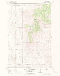
1988 Map of Hot Springs NE
USGS Topo · Published 1988About this map
The Flathead Indian Reservation dominates this landscape in western Montana, where the Little Bitterroot River meanders south through a broad valley flanked by high ridges. This 1988 revision, based on earlier data from the Bureau of Indian Affairs and the USGS, captures a semi-arid ranching and reservation environment defined by its water management. The Camas Canal and various flowing wells highlight the human effort to divert water toward the small settlement at Camas. In the rugged eastern terrain, narrow drainage systems like Garceau Gulch and Irvine Creek cut through the high country, while Camp Aqua sits along the river bottom, suggesting the area's local significance as a gathering place or thermal site. The map clearly delineates the administrative boundary between Lake and Sanders Counties, tracing the divide through the Little Bitterroot River corridor.
Find a feature on this map
18 named features on this map. Tap any name to fly to it.
Don’t see what you’re looking for? This feature index may not catch every label — zoom into the map to look around manually.
Map Details
Editions of this 1988 Hot Springs NE Map
This is the sole edition of this map. No revisions or reprints were ever made.
Other maps of this area

1920 · Flathead Lake
USGS Topo · 1:125,000

1956 · Wallace
USGS Topo · 1:250,000

1960 · Wallace
USGS Topo · 1:250,000

1964 · Irvine Lookout Tower
USGS Topo · 1:24,000

1964 · Mill Pocket Creek
USGS Topo · 1:24,000

1964 · Markle Pass
USGS Topo · 1:24,000

1964 · Lonepine
USGS Topo · 1:24,000

1964 · Hot Springs
USGS Topo · 1:24,000
1964 · Niarada
USGS Topo · 1:24,000
1964 · Hot Springs NE
USGS Topo · 1:24,000