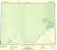
1951 Map of St Michael
USGS Topo · Published 1951This historical map portrays the area of St Michael in 1951, primarily covering Kusilvak Borough. Featuring a scale of 1:250000, this map provides a highly detailed snapshot of the terrain, roads, buildings, counties, and historical landmarks in the St Michael region at the time. Published in 1951, it is one of 2 known editions of this map due to revisions or reprints.
Map Details
Editions of this 1951 St Michael Map
2 editions found
Historical Maps of Kotlik Through Time
89 maps found

1951 Black
Kusilvak Borough, AK

1951 Holy Cross A-5
Kusilvak Borough, AK

1951 St Michael
Kusilvak Borough, AK

1952 Black A-1
Kusilvak Borough, AK

1952 Black A-2
Kusilvak Borough, AK

1952 Black B-1
Kusilvak Borough, AK

1952 Black C-1
Kusilvak Borough, AK

1952 Holy Cross A-5
Kusilvak Borough, AK

1952 Holy Cross A-6
Kusilvak Borough, AK

1952 Holy Cross B-5
Kusilvak Borough, AK

1952 Holy Cross B-6
Kusilvak Borough, AK

1952 Holy Cross C-5
Kusilvak Borough, AK

1952 Holy Cross C-6
Kusilvak Borough, AK

1952 Holy Cross D-5
Kusilvak Borough, AK

1952 Holy Cross D-6
Kusilvak Borough, AK

1952 Hooper Bay A-2
Kusilvak Borough, AK

1952 Hooper Bay B-3
Kusilvak Borough, AK

1952 Hooper Bay C-1
Kusilvak Borough, AK

1952 Hooper Bay C-3
Kusilvak Borough, AK

1952 Hooper Bay C-4
Kusilvak Borough, AK

1952 Hooper Bay D-1
Kusilvak Borough, AK

1952 Hooper Bay D-2
Kusilvak Borough, AK

1952 Kwiguk A-1
Kusilvak Borough, AK

1952 Kwiguk A-2
Kusilvak Borough, AK

1952 Kwiguk A-3
Kusilvak Borough, AK

1952 Kwiguk A-4
Kusilvak Borough, AK

1952 Kwiguk A-5
Kusilvak Borough, AK

1952 Kwiguk A-6
Kusilvak Borough, AK

1952 Kwiguk B-1
Kusilvak Borough, AK

1952 Kwiguk B-2
Kusilvak Borough, AK
1952 Kwiguk B-3
Kusilvak Borough, AK

1952 Kwiguk B-4
Kusilvak Borough, AK

1952 Kwiguk B-5
Kusilvak Borough, AK

1952 Kwiguk B-6
Kusilvak Borough, AK

1952 Kwiguk C-1
Kusilvak Borough, AK

1952 Kwiguk C-2
Kusilvak Borough, AK

1952 Kwiguk C-3
Kusilvak Borough, AK

1952 Kwiguk C-4
Kusilvak Borough, AK

1952 Kwiguk C-5
Kusilvak Borough, AK

1952 Kwiguk C-6
Kusilvak Borough, AK

1952 Kwiguk D-1
Kusilvak Borough, AK

1952 Kwiguk D-2
Kusilvak Borough, AK

1952 Kwiguk D-3
Kusilvak Borough, AK

1952 Kwiguk D-4
Kusilvak Borough, AK

1952 Kwiguk D-5
Kusilvak Borough, AK

1952 Kwiguk D-6
Kusilvak Borough, AK

1952 Kwiguk
Kusilvak Borough, AK

1952 Marshall C-1
Kusilvak Borough, AK

1952 Marshall C-5
Kusilvak Borough, AK

1952 Marshall C-6
Kusilvak Borough, AK

1952 Marshall C-7
Kusilvak Borough, AK

1952 Marshall C-8
Kusilvak Borough, AK

1952 Marshall D-1
Kusilvak Borough, AK

1952 Marshall D-2
Kusilvak Borough, AK

1952 Marshall D-3
Kusilvak Borough, AK

1952 Marshall D-4
Kusilvak Borough, AK

1952 Marshall D-5
Kusilvak Borough, AK

1952 Marshall D-6
Kusilvak Borough, AK

1952 Marshall D-7
Kusilvak Borough, AK

1952 Marshall D-8
Kusilvak Borough, AK

1952 Russian Mission C-7
Kusilvak Borough, AK

1952 Russian Mission C-8
Kusilvak Borough, AK

1952 Russian Mission D-5
Kusilvak Borough, AK

1952 Russian Mission D-6
Kusilvak Borough, AK

1952 Russian Mission D-7
Kusilvak Borough, AK

1952 Russian Mission D-8
Kusilvak Borough, AK

1952 Saint Michael A-1
Kusilvak Borough, AK

1952 Saint Michael A-2
Kusilvak Borough, AK

1952 Saint Michael A-3
Kusilvak Borough, AK

1952 Saint Michael A-4
Kusilvak Borough, AK

1952 Saint Michael A-5
Kusilvak Borough, AK

1952 Saint Michael A-6
Kusilvak Borough, AK

1952 St Michael
Kusilvak Borough, AK

1953 Hooper Bay B-1
Kusilvak Borough, AK

1953 Hooper Bay B-2
Kusilvak Borough, AK

1953 Hooper Bay C-2
Kusilvak Borough, AK

1953 Hooper Bay D-3
Kusilvak Borough, AK

1953 Marshall B-5
Kusilvak Borough, AK

1953 Marshall B-6
Kusilvak Borough, AK

1953 Marshall B-7
Kusilvak Borough, AK

1953 Marshall B-8
Kusilvak Borough, AK

1954 Hooper Bay A-1
Kusilvak Borough, AK

1954 Marshall A-7
Kusilvak Borough, AK

1954 Marshall A-8
Kusilvak Borough, AK

1954 Marshall C-2
Kusilvak Borough, AK

1954 Marshall C-3
Kusilvak Borough, AK

1954 Marshall C-4
Kusilvak Borough, AK

1957 Marshall B-7
Kusilvak Borough, AK

1964 St. Michael
Kusilvak Borough, AK