1958 Map of Isolation Peak
USGS Topo · Published 1960About this map
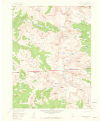
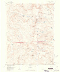
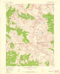
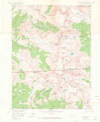
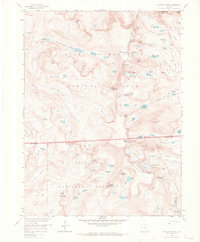
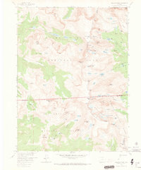
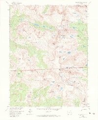
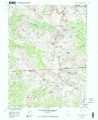
The Continental Divide forms the primary physical spine of this high-altitude landscape, carving through the heart of Rocky Mountain National Park and Roosevelt National Forest. The map documents a strictly wilderness character, dominated by sharp peaks and glacial cirques such as the Moomaw Glacier and Eagles Beak. Drainage patterns are clearly defined by chains of alpine lakes, including the cluster of Hutcheson Lakes and the isolated Pear Reservoir.
Find a feature on this map
98 named features on this map. Tap any name to fly to it.
Don’t see what you’re looking for? This feature index may not catch every label — zoom into the map to look around manually.
Map Details
Editions of this 1958 Isolation Peak Map
9 editions found
Historical Maps of Grand County Through Time
181 maps found

1915 Rocky Mountain National Park
Grand County, CO

1919 Rocky Mountain National Park
Grand County, CO

1933 Ute Peak
Grand County, CO

1937 Ute Peak
Grand County, CO

1956 Gore Pass
Grand County, CO

1956 Hyannis Peak
Grand County, CO

1956 Lake Agnes
Grand County, CO

1956 Parkview Mountain
Grand County, CO

1956 Radial Mountain
Grand County, CO

1956 Whiteley Peak
Grand County, CO

1957 Berthoud Pass
Grand County, CO

1957 Bottle Pass
Grand County, CO

1957 Bowen Mountain
Grand County, CO

1957 Byers Peak
Grand County, CO

1957 Trail Mountain
Grand County, CO

1958 East Portal
Grand County, CO

1958 Isolation Peak
Grand County, CO

1958 Monarch Lake
Grand County, CO

1958 Shadow Mountain
Grand County, CO

1958 Strawberry Lake
Grand County, CO

1972 Radium
Grand County, CO

1979 Battle Mountain
Grand County, CO

1979 Sylvan Reservoir
Grand County, CO

1980 Cabin Creek
Grand County, CO

1980 Corral Peaks
Grand County, CO

1980 Gore Pass
Grand County, CO

1980 Gunsight Pass
Grand County, CO

1980 Hinman Reservoir
Grand County, CO

1980 Junction Butte
Grand County, CO

1980 King Creek
Grand County, CO

1980 Sheephorn Mountain
Grand County, CO

1980 Tyler Mountain
Grand County, CO

1980 Ute Peak
Grand County, CO

2000 Corral Peaks
Grand County, CO

2000 Gore Pass
Grand County, CO

2000 Gunsight Pass
Grand County, CO

2000 Hyannis Peak
Grand County, CO

2000 Lake Agnes
Grand County, CO

2000 Parkview Mountain
Grand County, CO

2000 Tyler Mountain
Grand County, CO

2000 Whiteley Peak
Grand County, CO

2010 Hinman Reservoir
Grand County, CO

2010 Junction Butte
Grand County, CO

2011 Battle Mountain
Grand County, CO

2011 Berthoud Pass
Grand County, CO

2011 Bottle Pass
Grand County, CO

2011 Bowen Mountain
Grand County, CO

2011 Byers Peak
Grand County, CO

2011 Cabin Creek
Grand County, CO

2011 Corral Peaks
Grand County, CO

2011 East Portal
Grand County, CO

2011 Gore Pass
Grand County, CO

2011 Gunsight Pass
Grand County, CO

2011 Hyannis Peak
Grand County, CO

2011 Isolation Peak
Grand County, CO

2011 King Creek
Grand County, CO

2011 Lake Agnes
Grand County, CO

2011 Monarch Lake
Grand County, CO

2011 Parkview Mountain
Grand County, CO

2011 Radial Mountain
Grand County, CO

2011 Radium
Grand County, CO

2011 Shadow Mountain
Grand County, CO

2011 Sheephorn Mountain
Grand County, CO

2011 Strawberry Lake
Grand County, CO

2011 Sylvan Reservoir
Grand County, CO

2011 Trail Mountain
Grand County, CO

2011 Tyler Mountain
Grand County, CO

2011 Ute Peak
Grand County, CO

2011 Whiteley Peak
Grand County, CO

2013 Battle Mountain
Grand County, CO

2013 Berthoud Pass
Grand County, CO

2013 Bottle Pass
Grand County, CO

2013 Bowen Mountain
Grand County, CO

2013 Byers Peak
Grand County, CO

2013 Cabin Creek
Grand County, CO

2013 Corral Peaks
Grand County, CO

2013 East Portal
Grand County, CO

2013 Gore Pass
Grand County, CO

2013 Gunsight Pass
Grand County, CO

2013 Hinman Reservoir
Grand County, CO

2013 Hyannis Peak
Grand County, CO

2013 Isolation Peak
Grand County, CO

2013 Junction Butte
Grand County, CO

2013 King Creek
Grand County, CO

2013 Lake Agnes
Grand County, CO

2013 Monarch Lake
Grand County, CO

2013 Parkview Mountain
Grand County, CO

2013 Radial Mountain
Grand County, CO

2013 Radium
Grand County, CO

2013 Shadow Mountain
Grand County, CO

2013 Sheephorn Mountain
Grand County, CO

2013 Strawberry Lake
Grand County, CO

2013 Sylvan Reservoir
Grand County, CO

2013 Trail Mountain
Grand County, CO

2013 Tyler Mountain
Grand County, CO

2013 Ute Peak
Grand County, CO

2013 Whiteley Peak
Grand County, CO

2016 Battle Mountain
Grand County, CO

2016 Berthoud Pass
Grand County, CO

2016 Bottle Pass
Grand County, CO

2016 Bowen Mountain
Grand County, CO

2016 Byers Peak
Grand County, CO

2016 Cabin Creek
Grand County, CO

2016 Corral Peaks
Grand County, CO

2016 East Portal
Grand County, CO

2016 Gore Pass
Grand County, CO

2016 Gunsight Pass
Grand County, CO

2016 Hinman Reservoir
Grand County, CO

2016 Hyannis Peak
Grand County, CO

2016 Isolation Peak
Grand County, CO

2016 Junction Butte
Grand County, CO

2016 King Creek
Grand County, CO

2016 Lake Agnes
Grand County, CO

2016 Monarch Lake
Grand County, CO

2016 Parkview Mountain
Grand County, CO

2016 Radial Mountain
Grand County, CO

2016 Radium
Grand County, CO

2016 Shadow Mountain
Grand County, CO

2016 Sheephorn Mountain
Grand County, CO

2016 Strawberry Lake
Grand County, CO

2016 Sylvan Reservoir
Grand County, CO

2016 Trail Mountain
Grand County, CO

2016 Tyler Mountain
Grand County, CO

2016 Ute Peak
Grand County, CO

2016 Whiteley Peak
Grand County, CO

2019 Battle Mountain
Grand County, CO

2019 Berthoud Pass
Grand County, CO

2019 Bottle Pass
Grand County, CO

2019 Bowen Mountain
Grand County, CO

2019 Byers Peak
Grand County, CO

2019 Cabin Creek
Grand County, CO

2019 Corral Peaks
Grand County, CO

2019 East Portal
Grand County, CO

2019 Gore Pass
Grand County, CO

2019 Gunsight Pass
Grand County, CO

2019 Hinman Reservoir
Grand County, CO

2019 Hyannis Peak
Grand County, CO

2019 Isolation Peak
Grand County, CO

2019 Junction Butte
Grand County, CO

2019 King Creek
Grand County, CO

2019 Lake Agnes
Grand County, CO

2019 Monarch Lake
Grand County, CO

2019 Parkview Mountain
Grand County, CO

2019 Radial Mountain
Grand County, CO

2019 Radium
Grand County, CO

2019 Shadow Mountain
Grand County, CO

2019 Sheephorn Mountain
Grand County, CO

2019 Strawberry Lake
Grand County, CO

2019 Sylvan Reservoir
Grand County, CO

2019 Trail Mountain
Grand County, CO

2019 Tyler Mountain
Grand County, CO

2019 Ute Peak
Grand County, CO

2019 Whiteley Peak
Grand County, CO

2022 Battle Mountain
Grand County, CO

2022 Berthoud Pass
Grand County, CO

2022 Bottle Pass
Grand County, CO

2022 Bowen Mountain
Grand County, CO

2022 Byers Peak
Grand County, CO

2022 Cabin Creek
Grand County, CO

2022 Corral Peaks
Grand County, CO

2022 East Portal
Grand County, CO

2022 Gore Pass
Grand County, CO

2022 Gunsight Pass
Grand County, CO

2022 Hinman Reservoir
Grand County, CO

2022 Hyannis Peak
Grand County, CO

2022 Isolation Peak
Grand County, CO

2022 Junction Butte
Grand County, CO

2022 King Creek
Grand County, CO

2022 Lake Agnes
Grand County, CO

2022 Monarch Lake
Grand County, CO

2022 Parkview Mountain
Grand County, CO

2022 Radial Mountain
Grand County, CO

2022 Radium
Grand County, CO

2022 Shadow Mountain
Grand County, CO

2022 Sheephorn Mountain
Grand County, CO

2022 Strawberry Lake
Grand County, CO

2022 Sylvan Reservoir
Grand County, CO

2022 Trail Mountain
Grand County, CO

2022 Tyler Mountain
Grand County, CO

2022 Ute Peak
Grand County, CO

2022 Whiteley Peak
Grand County, CO