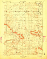
1899 Map of Goshen Hole
USGS Topo · Published 1911About this map
Goshen Hole defines this landscape in the late nineteenth century, characterized by a network of cattle ranches and intermittent water sources along the Wyoming Nebraska Boundary Line. The terrain is marked by prominent landforms such as Bear Creek Mtn and Table Mountain, which provided natural landmarks for early settlers and travelers. The distribution of named sites like Greasewood Ranch, Yoder's Ranch, and Marshalls Ranch illustrates the ranching economy that took hold before the widespread development of permanent towns. Early irrigation efforts are visible in the north near the North Platte River, where the Mitchell Canal and Lawrence Canal begin to move water into the arid plains. Small hubs like La Grange and Goshen appear as early points of community, while the presence of State Line Springs and Hawk Springs highlights the critical importance of reliable water in the High Plains.
Find a feature on this map
43 named features on this map. Tap any name to fly to it.
Don’t see what you’re looking for? This feature index may not catch every label — zoom into the map to look around manually.
Map Details
Editions of this 1899 Goshen Hole Map
4 editions found
Other maps of this area

1896 · Patrick
USGS Topo · 1:125,000

1896 · Hartville
USGS Topo · 1:125,000

1898 · Scotts Bluff
USGS Topo · 1:125,000

1899 · Goshen Hole
USGS Topo · 1:125,000

1899 · Whistle Creek
USGS Topo · 1:125,000

1901 · Hartville
USGS Topo · 1:125,000

1911 · Cheyenne
USGS Topo · 1:125,000

1914 · Cheyenne
USGS Topo · 1:125,000

1950 · Rockeagle
USGS Topo · 1:24,000

1954 · Scottsbluff
USGS Topo · 1:250,000