1965 Map of Chamberlain Mtn
USGS Topo · Published 1967About this map
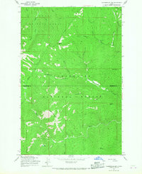
St Joe National Forest and Clearwater National Forest converge in this high-altitude interior, where Shoshone and Clearwater counties meet. The landscape is defined by the steep drainage basins of Fall Creek and Meadow Creek, etched with a network of historical transit routes including the Pack Trail. These paths served the extractive interests of the mid-20th century, notably connecting isolated sites like the Clearwater Mine and the Klug Cabin tucked near the headwaters of Fly Creek. High points such as Chamberlain Mtn and Birch Mountain tower over the valleys, providing a view of the complex gulch systems like Vanderbilt Gulch and Niagara Gulch. The presence of Chamberlain Meadows and Fly Lake suggests the few pockets of level ground and permanent water that supported the seasonal activities of foresters, miners, and early surveyors in this demanding Idaho terrain.
Find a feature on this map
25 named features on this map. Tap any name to fly to it.
Don’t see what you’re looking for? This feature index may not catch every label — zoom into the map to look around manually.
Map Details
Editions of this 1965 Chamberlain Mtn Map
2 editions found
Historical Maps of Clearwater County Through Time
175 maps found

1909 Cataldo
Shoshone County, ID

1911 Cataldo
Shoshone County, ID

1914 Avery
Shoshone County, ID

1917 Avery
Shoshone County, ID

1950 Twin Crags
Shoshone County, ID

1952 Twin Crags
Shoshone County, ID

1957 Burke
Shoshone County, ID

1957 Calder
Shoshone County, ID

1957 Simmons Peak
Shoshone County, ID

1963 Bacon Peak
Shoshone County, ID

1963 Buzzard Roost
Shoshone County, ID

1963 Mallard Peak
Shoshone County, ID

1963 Pole Mtn
Shoshone County, ID

1965 Chamberlain Mtn
Shoshone County, ID

1965 Hoodoo Pass
Shoshone County, ID

1966 Cathedral Peak
Shoshone County, ID

1966 Jordan Creek
Shoshone County, ID

1966 Pond Peak
Shoshone County, ID

1966 Spyglass Peak
Shoshone County, ID

1966 Taylor Peak
Shoshone County, ID

1969 Anthony Peak
Shoshone County, ID

1969 Bathtub Mtn
Shoshone County, ID

1969 Fishhook Creek
Shoshone County, ID

1969 Grandmother Mountain
Shoshone County, ID

1969 Grice Ridge
Shoshone County, ID

1969 Hoyt Mountain
Shoshone County, ID

1969 Huckleberry Mtn
Shoshone County, ID

1969 Marble Mtn
Shoshone County, ID

1969 Merry Creek
Shoshone County, ID

1969 Montana Peak
Shoshone County, ID

1969 Monumental Buttes
Shoshone County, ID

1969 Thor Mountain
Shoshone County, ID

1969 Three Sisters
Shoshone County, ID

1969 Widow Mtn
Shoshone County, ID

1981 Little Goat Mountains
Shoshone County, ID

1981 Pinchot Butte
Shoshone County, ID

1985 Bumblebee Peak
Shoshone County, ID

1985 Burke
Shoshone County, ID

1985 Cataldo
Shoshone County, ID

1985 Grizzly Mountain
Shoshone County, ID

1985 Kellogg East
Shoshone County, ID

1985 Kellogg West
Shoshone County, ID

1985 Murray
Shoshone County, ID

1985 Prichard
Shoshone County, ID

1985 Steamboat Creek
Shoshone County, ID

1985 St. Joe
Shoshone County, ID

1988 Adair
Shoshone County, ID

1988 Avery
Shoshone County, ID

1988 Berge Peak
Shoshone County, ID

1988 Calder
Shoshone County, ID

1988 Conrad Peak
Shoshone County, ID

1988 Marble Creek
Shoshone County, ID

1988 Masonia
Shoshone County, ID

1988 Mastodon Mountain
Shoshone County, ID

1988 Peggy Peak
Shoshone County, ID

1988 Polaris Peak
Shoshone County, ID

1988 Red Ives Peak
Shoshone County, ID

1988 Shefoot Mountain
Shoshone County, ID

1988 Sherlock Peak
Shoshone County, ID

1990 Bechtel Butte
Shoshone County, ID

1990 Clarkia
Shoshone County, ID

1990 Crystal Peak
Shoshone County, ID

1990 Faset Peak
Shoshone County, ID

1990 Lamb Peak
Shoshone County, ID

1994 Anthony Peak
Shoshone County, ID

1994 Bacon Peak
Shoshone County, ID

1994 Bechtel Butte
Shoshone County, ID

1994 Buzzard Roost
Shoshone County, ID

1994 Chamberlain Mtn
Shoshone County, ID

1994 Grice Ridge
Shoshone County, ID

1994 Hoodoo Pass
Shoshone County, ID

1994 Mallard Peak
Shoshone County, ID

1994 Pinchot Butte
Shoshone County, ID

1994 Pole Mountain
Shoshone County, ID

1995 Adair
Shoshone County, ID

1995 Avery
Shoshone County, ID

1995 Bathtub Mountain
Shoshone County, ID

1995 Berge Peak
Shoshone County, ID

1995 Calder
Shoshone County, ID

1995 Clarkia
Shoshone County, ID

1995 Conrad Peak
Shoshone County, ID

1995 Crystal Peak
Shoshone County, ID

1995 Fishhook Creek
Shoshone County, ID

1995 Grandmother Mountain
Shoshone County, ID

1995 Hoyt Mountain
Shoshone County, ID

1995 Huckleberry Mountain
Shoshone County, ID

1995 Marble Creek
Shoshone County, ID

1995 Marble Mountain
Shoshone County, ID

1995 Masonia
Shoshone County, ID

1995 Mastodon Mountain
Shoshone County, ID

1995 Merry Creek
Shoshone County, ID

1995 Montana Peak
Shoshone County, ID

1995 Monumental Buttes
Shoshone County, ID

1995 Peggy Peak
Shoshone County, ID

1995 Red Ives Peak
Shoshone County, ID

1995 Shefoot Mountain
Shoshone County, ID

1995 Sherlock Peak
Shoshone County, ID

1995 St. Joe
Shoshone County, ID

1995 Thor Mountain
Shoshone County, ID

1995 Three Sisters
Shoshone County, ID

1995 Widow Mountain
Shoshone County, ID

1996 Bumblebee Peak
Shoshone County, ID

1996 Burke
Shoshone County, ID

1996 Cataldo
Shoshone County, ID

1996 Cathedral Peak
Shoshone County, ID

1996 Faset Peak
Shoshone County, ID

1996 Grizzly Mountain
Shoshone County, ID

1996 Jordan Creek
Shoshone County, ID

1996 Kellogg East
Shoshone County, ID

1996 Kellogg West
Shoshone County, ID

1996 Lamb Peak
Shoshone County, ID

1996 Murray
Shoshone County, ID

1996 Polaris Peak
Shoshone County, ID

1996 Pond Peak
Shoshone County, ID

1996 Prichard
Shoshone County, ID

1996 Spyglass Peak
Shoshone County, ID

1996 Steamboat Creek
Shoshone County, ID

1996 Taylor Peak
Shoshone County, ID

1996 Twin Crags
Shoshone County, ID

2024 Adair
Shoshone County, ID

2024 Anthony Peak
Shoshone County, ID

2024 Avery
Shoshone County, ID

2024 Bacon Peak
Shoshone County, ID

2024 Bathtub Mountain
Shoshone County, ID

2024 Bechtel Butte
Shoshone County, ID

2024 Berge Peak
Shoshone County, ID

2024 Bumblebee Peak
Shoshone County, ID

2024 Burke
Shoshone County, ID

2024 Buzzard Roost
Shoshone County, ID

2024 Calder
Shoshone County, ID

2024 Cataldo
Shoshone County, ID

2024 Cathedral Peak
Shoshone County, ID

2024 Chamberlain Mountain
Shoshone County, ID

2024 Clarkia
Shoshone County, ID

2024 Conrad Peak
Shoshone County, ID

2024 Crystal Peak
Shoshone County, ID

2024 Faset Peak
Shoshone County, ID

2024 Fishhook Creek
Shoshone County, ID

2024 Grandmother Mountain
Shoshone County, ID

2024 Grice Ridge
Shoshone County, ID

2024 Grizzly Mountain
Shoshone County, ID

2024 Hoodoo Pass
Shoshone County, ID

2024 Hoyt Mountain
Shoshone County, ID

2024 Huckleberry Mountain
Shoshone County, ID

2024 Jordan Creek
Shoshone County, ID

2024 Kellogg East
Shoshone County, ID

2024 Kellogg West
Shoshone County, ID

2024 Lamb Peak
Shoshone County, ID

2024 Little Goat Mountains
Shoshone County, ID

2024 Mallard Peak
Shoshone County, ID

2024 Marble Creek
Shoshone County, ID

2024 Marble Mountain
Shoshone County, ID

2024 Masonia
Shoshone County, ID

2024 Mastodon Mountain
Shoshone County, ID

2024 Merry Creek
Shoshone County, ID

2024 Montana Peak
Shoshone County, ID

2024 Monumental Buttes
Shoshone County, ID

2024 Murray
Shoshone County, ID

2024 Peggy Peak
Shoshone County, ID

2024 Pinchot Butte
Shoshone County, ID

2024 Polaris Peak
Shoshone County, ID

2024 Pole Mountain
Shoshone County, ID

2024 Pond Peak
Shoshone County, ID

2024 Prichard
Shoshone County, ID

2024 Red Ives Peak
Shoshone County, ID

2024 Saint Joe
Shoshone County, ID

2024 Shefoot Mountain
Shoshone County, ID

2024 Sherlock Peak
Shoshone County, ID

2024 Spyglass Peak
Shoshone County, ID

2024 Steamboat Creek
Shoshone County, ID

2024 Taylor Peak
Shoshone County, ID

2024 Thor Mountain
Shoshone County, ID

2024 Three Sisters
Shoshone County, ID

2024 Twin Crags
Shoshone County, ID

2024 Widow Mountain
Shoshone County, ID