
1993 Map of Molokai Airport
USGS Topo · Published 2002About this map
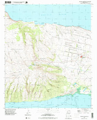
Hoolehua Homesteads and Palaau Homesteads anchor the central plateau of Molokai, where the mid-century agricultural landscape transitions into the modern infrastructure of the Molokai Airport. This mid-1990s record of the island's central region illustrates a complex network of land divisions and homesteads situated between the rugged northern coast and the southern tidal flats. The interior is marked by a deep-cut series of gulches, including Naiwa Gulch and Waihewahewa Gulch, which funnel toward the Pacific Ocean.
Find a feature on this map
80 named features on this map. Tap any name to fly to it.
Don’t see what you’re looking for? This feature index may not catch every label — zoom into the map to look around manually.
Map Details
Editions of this 1993 Molokai Airport Map
2 editions found
Historical Maps of Mahana Through Time
156 maps found

1923 Island of Lanai
Maui County, HI

1925 Island of Lanai
Maui County, HI

1929 Kahoolawe
Maui County, HI

1952 Halawa
Maui County, HI

1952 Ilio Point
Maui County, HI

1952 Kamalo
Maui County, HI

1952 Molokai Airport
Maui County, HI

1954 Maui
Maui County, HI

1954 Puu O Kali
Maui County, HI

1955 Kahakuloa
Maui County, HI

1956 Honolua
Maui County, HI

1957 Haiku
Maui County, HI

1957 Kaupo
Maui County, HI

1957 Keanae
Maui County, HI

1957 Kilohana
Maui County, HI

1957 Kipahulu
Maui County, HI

1957 Lualailua Hills
Maui County, HI

1957 Nahiku
Maui County, HI

1966 Maui
Maui County, HI

1968 Halawa
Maui County, HI

1968 Ilio Point
Maui County, HI

1968 Kamalo
Maui County, HI

1968 Molokai Airport
Maui County, HI

1974 Maui
Maui County, HI

1983 Haiku
Maui County, HI

1983 Honolua
Maui County, HI

1983 Kahakuloa
Maui County, HI

1983 Kaupo
Maui County, HI

1983 Keanae
Maui County, HI

1983 Kilohana
Maui County, HI

1983 Kipahulu
Maui County, HI

1983 Lualailua Hills
Maui County, HI

1983 Molokai East
Maui County, HI

1983 Nahiku
Maui County, HI

1983 Puu O Kali
Maui County, HI

1984 Kahoolawe
Maui County, HI

1984 Lanai North
Maui County, HI

1984 Lanai South
Maui County, HI

1991 Garden Of The Gods
Maui County, HI

1991 Kahoolawe East
Maui County, HI

1991 Kahoolawe West
Maui County, HI

1991 Kilohana
Maui County, HI

1991 Makalau
Maui County, HI

1992 Haalelepaakai
Maui County, HI

1992 Haiku
Maui County, HI

1992 Keanae
Maui County, HI

1992 Nahiku
Maui County, HI

1992 Puu O Kali
Maui County, HI
1993 Molokai Airport
Maui County, HI

1995 Kipahulu
Maui County, HI

1995 Luala'ilua Hills
Maui County, HI

1996 Kaupo
Maui County, HI

1997 Kahakuloa
Maui County, HI

1997 Napili
Maui County, HI

2013 Haiku
Maui County, HI

2013 Halawa
Maui County, HI

2013 Halawa OE S
Maui County, HI

2013 Ilio Point
Maui County, HI

2013 Ilio Point OE N
Maui County, HI

2013 Ilio Point OE S
Maui County, HI

2013 Kahakuloa
Maui County, HI

2013 Kahoolawe
Maui County, HI

2013 Kahoolawe OE E
Maui County, HI

2013 Kahoolawe OE NE
Maui County, HI

2013 Kahoolawe OE N
Maui County, HI

2013 Kahoolawe OE W
Maui County, HI

2013 Kamalo
Maui County, HI

2013 Kamalo OE S
Maui County, HI

2013 Kaunakakai OE N
Maui County, HI

2013 Kaunakakai OE S
Maui County, HI

2013 Kaupo
Maui County, HI

2013 Keanae
Maui County, HI

2013 Kilohana
Maui County, HI

2013 Kipahulu
Maui County, HI

2013 Lanai North
Maui County, HI

2013 Lanai North OE E
Maui County, HI

2013 Lanai North OE W
Maui County, HI

2013 Lanai South
Maui County, HI

2013 Lanai South OE E
Maui County, HI

2013 Lanai South OE W
Maui County, HI

2013 Lualailua Hills
Maui County, HI

2013 Makena OE S
Maui County, HI

2013 Molokai Airport
Maui County, HI

2013 Molokai Airport OE N
Maui County, HI

2013 Molokai Airport OE S
Maui County, HI

2013 Nahiku
Maui County, HI

2013 Napili
Maui County, HI

2013 Puu O Kali
Maui County, HI

2017 Haiku
Maui County, HI

2017 Halawa
Maui County, HI

2017 Halawa OE S
Maui County, HI

2017 Ilio Point
Maui County, HI

2017 Ilio Point OE N
Maui County, HI

2017 Ilio Point OE S
Maui County, HI

2017 Kahakuloa
Maui County, HI

2017 Kahoolawe
Maui County, HI

2017 Kahoolawe OE E
Maui County, HI

2017 Kahoolawe OE NE
Maui County, HI

2017 Kahoolawe OE N
Maui County, HI

2017 Kahoolawe OE W
Maui County, HI

2017 Kamalo
Maui County, HI

2017 Kamalo OE S
Maui County, HI

2017 Kaunakakai OE N
Maui County, HI

2017 Kaunakakai OE S
Maui County, HI

2017 Kaupo
Maui County, HI

2017 Keanae
Maui County, HI

2017 Kilohana
Maui County, HI

2017 Kipahulu
Maui County, HI

2017 Lanai North
Maui County, HI

2017 Lanai North OE E
Maui County, HI

2017 Lanai North OE W
Maui County, HI

2017 Lanai South
Maui County, HI

2017 Lanai South OE E
Maui County, HI

2017 Lanai South OE W
Maui County, HI

2017 Lualailua Hills
Maui County, HI

2017 Makena OE S
Maui County, HI

2017 Molokai Airport
Maui County, HI

2017 Molokai Airport OE N
Maui County, HI

2017 Molokai Airport OE S
Maui County, HI

2017 Nahiku
Maui County, HI

2017 Napili
Maui County, HI

2017 Puu O Kali
Maui County, HI

2024 Haiku
Maui County, HI

2024 Halawa
Maui County, HI

2024 Halawa OE S
Maui County, HI

2024 Ilio Point
Maui County, HI

2024 Ilio Point OE N
Maui County, HI

2024 Ilio Point OE S
Maui County, HI

2024 Kahakuloa
Maui County, HI

2024 Kahoolawe
Maui County, HI

2024 Kahoolawe OE E
Maui County, HI

2024 Kahoolawe OE NE
Maui County, HI

2024 Kahoolawe OE N
Maui County, HI

2024 Kahoolawe OE W
Maui County, HI

2024 Kamalo
Maui County, HI

2024 Kamalo OE S
Maui County, HI

2024 Kaunakakai OE N
Maui County, HI

2024 Kaunakakai OE S
Maui County, HI

2024 Kaupo
Maui County, HI

2024 Keanae
Maui County, HI

2024 Kilohana
Maui County, HI

2024 Kipahulu
Maui County, HI

2024 Lanai North
Maui County, HI

2024 Lanai North OE E
Maui County, HI

2024 Lanai North OE W
Maui County, HI

2024 Lanai South
Maui County, HI

2024 Lanai South OE E
Maui County, HI

2024 Lanai South OE W
Maui County, HI

2024 Lualailua Hills
Maui County, HI

2024 Makena OE S
Maui County, HI

2024 Molokai Airport
Maui County, HI

2024 Molokai Airport OE N
Maui County, HI

2024 Molokai Airport OE S
Maui County, HI

2024 Nahiku
Maui County, HI

2024 Napili
Maui County, HI

2024 Puu O Kali
Maui County, HI