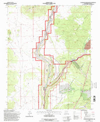
1995 Map of Guadalupe Mountain
USGS Topo · Published 1998About this map
Guadalupe Mountain and Brushy Mountain flank the deep incision of the Rio Grande as it cuts through the volcanic landscape of Taos County. The river corridor is protected within the Rio Grande Wild and Scenic River, where the Rio Grande Wild and Scenic River Visitor Center serves as a focal point for the canyon's natural history. To the east, the Carson National Forest encompasses dramatic relief including Lama Canyon and Alamo Canyon. Human activity in the mid-1990s is visible in the operation of the Red River State Fish Hatchery at the confluence of the Red River and the Rio Grande, along with a Microwave Tower and Radio Facility perched on the high mesas. The terrain is marked by volcanic features like Cerro Chiflo and the broad, flat expanse of Cebolla Mesa above the river gorge.
Find a feature on this map
21 named features on this map. Tap any name to fly to it.
Don’t see what you’re looking for? This feature index may not catch every label — zoom into the map to look around manually.
Map Details
Editions of this 1995 Guadalupe Mountain Map
This is the sole edition of this map. No revisions or reprints were ever made.
Other maps of this area

1954 · Raton
USGS Topo · 1:250,000

1958 · Raton
USGS Topo · 1:250,000

1963 · Arroyo Seco
USGS Topo · 1:24,000

1963 · Arroyo Hondo
USGS Topo · 1:24,000

1963 · Tres Piedras NE
USGS Topo · 1:24,000

1963 · Cerro De La Olla
USGS Topo · 1:24,000

1963 · Cerro
USGS Topo · 1:24,000

1963 · Sunshine
USGS Topo · 1:24,000

1963 · Cerro De Los Taoses
USGS Topo · 1:24,000

1963 · Questa
USGS Topo · 1:24,000