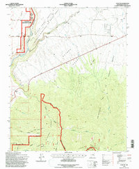
1995 Map of Taos SW
USGS Topo · Published 1997About this map
The Cañon del Rio Grande serves as the dominant western landmark of this high-altitude landscape, where the Rio Grande Wild & Scenic River carves a deep path through the plateau. This mid-1990s revision reveals a terrain defined by ancient land boundaries, including the Antonio Martinez or Godot Grant Tract A and the Gijosa Grant, reflecting the complex history of Spanish and Mexican land tenure in northern New Mexico. Small settlements like Pueblo Lower and Rio Vista appear near the canyon rim, while the southern reaches rise into the Picuris Mountains within the Carson National Forest. The map documents numerous ephemeral watercourses and vital water sources such as Rio Grande Spring, Warm Springs, and Agua Caliente, which have long supported life in this arid environment. The intricate network of canyons, including Lumbre Canyon and Hondo Canyon, illustrates the erosive power of seasonal arroyos across the Cristoval de la Serna Grant.
Find a feature on this map
31 named features on this map. Tap any name to fly to it.
Don’t see what you’re looking for? This feature index may not catch every label — zoom into the map to look around manually.
Map Details
Editions of this 1995 Taos SW Map
This is the sole edition of this map. No revisions or reprints were ever made.
Other maps of this area

1953 · Trampas
USGS Topo · 1:24,000

1954 · Raton
USGS Topo · 1:250,000

1958 · Raton
USGS Topo · 1:250,000

1961 · Carson
USGS Topo · 1:24,000

1961 · Tres Orejas
USGS Topo · 1:24,000

1964 · Los Cordovas
USGS Topo · 1:24,000

1964 · Taos
USGS Topo · 1:24,000

1964 · Tres Ritos
USGS Topo · 1:24,000

1964 · Ranchos De Taos
USGS Topo · 1:24,000

1964 · Penasco
USGS Topo · 1:24,000