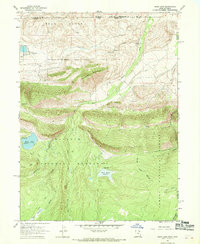
1967 Map of Hoop Lake
USGS Topo · Published 1969About this map
Wasatch National Forest and Ashley National Forest converge in this high-altitude corner of the Uinta Mountains during the late 1960s. The landscape is defined by its water management and resource history, featuring the Beaver Meadow Reservoir and Hoop Lake, where a boat ramp and campground are noted. The presence of Coal Mine Hill and several drill holes suggests a history of mineral exploration amidst the timber and grazing lands. Movement through these forests relied on a network of paths like the Thompson Creek Trail, Jeep Trails, and various Pack Trails that navigated around Widdop Mountain and the Bald Range. This survey captures the state line area where Wyoming and Utah meet, showing the transition from the Gregory Basin to the lush Kabell Meadows and Bull Park.
Find a feature on this map
30 named features on this map. Tap any name to fly to it.
Don’t see what you’re looking for? This feature index may not catch every label — zoom into the map to look around manually.
Map Details
Editions of this 1967 Hoop Lake Map
This is the sole edition of this map. No revisions or reprints were ever made.
Other maps of this area

1885 · Ashley
USGS Topo · 1:250,000

1885 · Uinta
USGS Topo · 1:250,000

1905 · Gilbert Peak
USGS Topo · 1:125,000

1906 · Gilbert Peak
USGS Topo · 1:125,000

1906 · Marsh Peak
USGS Topo · 1:125,000

1908 · Marsh Peak
USGS Topo · 1:125,000

1954 · Salt Lake City
USGS Topo · 1:250,000

1954 · Vernal
USGS Topo · 1:250,000

1954 · Ogden
USGS Topo · 1:250,000

1954 · Rock Springs
USGS Topo · 1:250,000