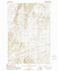
1987 Map of Negro Hollow
USGS Topo · Published 1988About this map
Negro Hollow characterizes this Jefferson County landscape, where the high-altitude terrain is carved by a network of drainage corridors. Surveyed in the late 1980s, the map reveals a remote area dominated by significant topographical shifts, specifically around Cottonwood Canyon and the southern reaches of Timber Canyon. These natural features dictate the passage through the region, with Milligan Canyon Road serving as one of the few established thoroughfares navigating the complex elevation changes. The presence of Rock Spring and an additional unnamed Spring suggests the vital importance of natural water sources in this high Montana environment. This provisional survey captures the intersection of natural landmarks and rural transit routes before modern development, offering a precise view of the geographic formations that have historically shaped local land use.
Find a feature on this map
8 named features on this map. Tap any name to fly to it.
Don’t see what you’re looking for? This feature index may not catch every label — zoom into the map to look around manually.
Map Details
Editions of this 1987 Negro Hollow Map
This is the sole edition of this map. No revisions or reprints were ever made.
Other maps of this area

1886 · Fort Logan
USGS Topo · 1:250,000

1888 · Three Forks
USGS Topo · 1:250,000

1894 · Three Forks
USGS Topo · 1:250,000

1895 · Three Forks
USGS Topo · 1:250,000

1947 · Bozeman
USGS Topo · 1:250,000

1948 · Bozeman
USGS Topo · 1:250,000

1948 · White Sulphur Springs
USGS Topo · 1:250,000

1949 · Radersburg
USGS Topo · 1:62,500

1950 · Devils Fence
USGS Topo · 1:62,500

1950 · Three Forks
USGS Topo · 1:62,500