
1968 Map of Pointe aux Marchettes
USGS Topo · Published 1978About this map
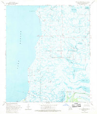
Lake Borgne and the sprawling marshlands of St. Bernard Parish dominate this coastal survey, where the intricate hydrology of the Mississippi River Delta is on full display. This landscape is defined by the Biloxi State Wildlife Management Area, a vast expanse of wetlands threaded by a complex network of waterways including Biloxi Bayou, Hasouse Bayou, and Magnolia Bayou. The map reveals the intersection of conservation and industry, showing the Bayou Biloxi Gas Field and a scattered Drill Hole alongside sensitive estuarine environments. Navigation is marked by a Light near the mouth of Bayou St Malo, while the presence of Magnolia Mound provides a rare point of relief in the low-lying terrain. From the northern reaches of Magill Lagoon to the southern sweep of Bayou La Loutre, the map documents a territory where shifting shorelines at Pte aux Marchettes reflect the constant influence of the Gulf's tides.
Find a feature on this map
32 named features on this map. Tap any name to fly to it.
Don’t see what you’re looking for? This feature index may not catch every label — zoom into the map to look around manually.
Map Details
Editions of this 1968 Pointe aux Marchettes Map
3 editions found
Historical Maps of Saint Malo Through Time
241 maps found

1892 St. Bernard
St. Bernard Parish, LA

1893 Cat Island
St. Bernard Parish, LA

1893 Chandeleur
St. Bernard Parish, LA

1893 La Fortuna
St. Bernard Parish, LA

1893 Rigolets
St. Bernard Parish, LA

1893 Shell Beach
St. Bernard Parish, LA

1895 Bodreau
St. Bernard Parish, LA

1935 Lake Athanasio
St. Bernard Parish, LA

1935 Lake Calebasse
St. Bernard Parish, LA

1935 Mitchell Keys
St. Bernard Parish, LA

1935 Morgan Harbor
St. Bernard Parish, LA

1936 Rigolets
St. Bernard Parish, LA

1939 Shell Beach
St. Bernard Parish, LA

1941 Shell Beach
St. Bernard Parish, LA

1942 St. Bernard
St. Bernard Parish, LA

1946 Isle Au Pitre
St. Bernard Parish, LA

1946 Lake Eugenie
St. Bernard Parish, LA

1946 Malheureux Point
St. Bernard Parish, LA

1946 Oak Mound Bayou
St. Bernard Parish, LA

1947 Lake Athanasio
St. Bernard Parish, LA

1947 Lake Eloi
St. Bernard Parish, LA

1947 Martello Castle
St. Bernard Parish, LA

1949 Door Point
St. Bernard Parish, LA

1949 False Mouth Bayou
St. Bernard Parish, LA

1949 Grand Island Pass
St. Bernard Parish, LA

1949 Three Mile Bay
St. Bernard Parish, LA

1951 Chandeleur Light
St. Bernard Parish, LA

1951 Freemason Island
St. Bernard Parish, LA

1951 Martello Castle
St. Bernard Parish, LA

1951 New Harbor Islands
St. Bernard Parish, LA

1951 North Islands
St. Bernard Parish, LA

1951 Stake Islands
St. Bernard Parish, LA

1954 Isle Au Pitre
St. Bernard Parish, LA

1954 Lake Eloi
St. Bernard Parish, LA

1954 Lake Eugenie
St. Bernard Parish, LA

1954 Malheureux Point
St. Bernard Parish, LA

1954 Mitchell Keys
St. Bernard Parish, LA

1954 Morgan Harbor
St. Bernard Parish, LA

1954 Oak Mound Bayou
St. Bernard Parish, LA

1955 Door Point
St. Bernard Parish, LA

1955 False Mouth Bayou
St. Bernard Parish, LA

1955 Isle Au Pitre
St. Bernard Parish, LA

1955 Lake Athanasio
St. Bernard Parish, LA

1955 Lake Eloi
St. Bernard Parish, LA

1955 Lake Eugenie
St. Bernard Parish, LA

1955 Lena Lagoon
St. Bernard Parish, LA

1955 Malheureux Point
St. Bernard Parish, LA

1955 Mitchell Key
St. Bernard Parish, LA

1955 Morgan Harbor
St. Bernard Parish, LA

1955 Oak Mound Bayou
St. Bernard Parish, LA

1955 Point Chicot
St. Bernard Parish, LA

1955 Pointe aux Marchettes
St. Bernard Parish, LA

1955 St. Bernard
St. Bernard Parish, LA

1955 Three Mile Bay
St. Bernard Parish, LA

1956 Isle Au Pitre
St. Bernard Parish, LA

1956 Rigolets
St. Bernard Parish, LA

1957 Proctor Point
St. Bernard Parish, LA

1957 Yscloskey
St. Bernard Parish, LA

1957 Yscloskey
St. Bernard Parish, LA

1967 Martello Castle
St. Bernard Parish, LA

1968 False Mouth Bayou
St. Bernard Parish, LA

1968 Lena Lagoon
St. Bernard Parish, LA
1968 Pointe aux Marchettes
St. Bernard Parish, LA

1968 Proctor Point
St. Bernard Parish, LA

1968 Yscloskey
St. Bernard Parish, LA

1969 Rigolets
St. Bernard Parish, LA

1969 St. Bernard
St. Bernard Parish, LA

1969 Yscloskey
St. Bernard Parish, LA

1973 Black Bay North
St. Bernard Parish, LA

1982 Chandeleur Light
St. Bernard Parish, LA

1982 North Islands
St. Bernard Parish, LA

1983 Black Bay
St. Bernard Parish, LA

1993 Lena Lagoon
St. Bernard Parish, LA

1994 Door Point
St. Bernard Parish, LA

1994 False Mouth Bayou
St. Bernard Parish, LA

1994 Isle Au Pitre
St. Bernard Parish, LA

1994 Lake Athanasio
St. Bernard Parish, LA

1994 Lake Eloi
St. Bernard Parish, LA

1994 Lake Eugenie
St. Bernard Parish, LA

1994 Malheureux Point
St. Bernard Parish, LA

1994 Mitchell Island
St. Bernard Parish, LA

1994 Morgan Harbor
St. Bernard Parish, LA

1994 Oak Mound Bayou
St. Bernard Parish, LA

1994 Pointe Aux Marchettes
St. Bernard Parish, LA

1994 Proctor Point
St. Bernard Parish, LA

1994 Three Mile Bay
St. Bernard Parish, LA

1994 Yscloskey
St. Bernard Parish, LA

1998 Chandeleur Light
St. Bernard Parish, LA

1998 Freemason Island
St. Bernard Parish, LA

1998 Martello Castle
St. Bernard Parish, LA

1998 New Harbor Islands
St. Bernard Parish, LA

1998 North Islands
St. Bernard Parish, LA

2012 Black Bay North
St. Bernard Parish, LA

2012 Chandeleur Light OE W
St. Bernard Parish, LA

2012 Chandeleur Light
St. Bernard Parish, LA

2012 Curlew Islands OE E
St. Bernard Parish, LA

2012 Curlew Islands
St. Bernard Parish, LA

2012 Door Point
St. Bernard Parish, LA

2012 False Mouth Bayou
St. Bernard Parish, LA

2012 Freemason Island
St. Bernard Parish, LA

2012 Isle au Pitre
St. Bernard Parish, LA

2012 Lake Athanasio
St. Bernard Parish, LA

2012 Lake Eloi
St. Bernard Parish, LA

2012 Lake Eugenie
St. Bernard Parish, LA

2012 Lena Lagoon
St. Bernard Parish, LA

2012 Malheureux Point
St. Bernard Parish, LA

2012 Martello Castle
St. Bernard Parish, LA

2012 Mitchell Island
St. Bernard Parish, LA

2012 Morgan Harbor OE E
St. Bernard Parish, LA

2012 Morgan Harbor
St. Bernard Parish, LA

2012 New Harbor Islands
St. Bernard Parish, LA

2012 North Islands OE W
St. Bernard Parish, LA

2012 North Islands
St. Bernard Parish, LA

2012 Oak Mound Bayou
St. Bernard Parish, LA

2012 Point Chicot
St. Bernard Parish, LA

2012 Pointe aux Marchettes
St. Bernard Parish, LA

2012 Proctor Point
St. Bernard Parish, LA

2012 Three Mile Bay
St. Bernard Parish, LA

2012 Yscloskey
St. Bernard Parish, LA

2015 Black Bay North
St. Bernard Parish, LA

2015 Chandeleur Light OE W
St. Bernard Parish, LA

2015 Chandeleur Light
St. Bernard Parish, LA

2015 Curlew Islands OE E
St. Bernard Parish, LA

2015 Curlew Islands
St. Bernard Parish, LA

2015 Door Point
St. Bernard Parish, LA

2015 False Mouth Bayou
St. Bernard Parish, LA

2015 Freemason Island OE W
St. Bernard Parish, LA

2015 Freemason Island
St. Bernard Parish, LA

2015 Isle au Pitre
St. Bernard Parish, LA

2015 Lake Athanasio OE S
St. Bernard Parish, LA

2015 Lake Athanasio
St. Bernard Parish, LA

2015 Lake Eloi
St. Bernard Parish, LA

2015 Lake Eugenie
St. Bernard Parish, LA

2015 Lena Lagoon
St. Bernard Parish, LA

2015 Malheureux Point
St. Bernard Parish, LA

2015 Martello Castle
St. Bernard Parish, LA

2015 Mitchell Island
St. Bernard Parish, LA

2015 Morgan Harbor OE E
St. Bernard Parish, LA

2015 Morgan Harbor
St. Bernard Parish, LA

2015 New Harbor Islands
St. Bernard Parish, LA

2015 North Islands OE W
St. Bernard Parish, LA

2015 North Islands
St. Bernard Parish, LA

2015 Oak Mound Bayou
St. Bernard Parish, LA

2015 Point Chicot
St. Bernard Parish, LA

2015 Pointe aux Marchettes
St. Bernard Parish, LA

2015 Proctor Point
St. Bernard Parish, LA

2015 Three Mile Bay
St. Bernard Parish, LA

2015 Yscloskey
St. Bernard Parish, LA

2018 Black Bay North
St. Bernard Parish, LA

2018 Chandeleur Light OE W
St. Bernard Parish, LA

2018 Chandeleur Light
St. Bernard Parish, LA

2018 Curlew Islands OE E
St. Bernard Parish, LA

2018 Curlew Islands
St. Bernard Parish, LA

2018 Door Point
St. Bernard Parish, LA

2018 False Mouth Bayou
St. Bernard Parish, LA

2018 Freemason Island OE W
St. Bernard Parish, LA

2018 Freemason Island
St. Bernard Parish, LA

2018 Isle au Pitre
St. Bernard Parish, LA

2018 Lake Athanasio OE S
St. Bernard Parish, LA

2018 Lake Athanasio
St. Bernard Parish, LA

2018 Lake Eloi
St. Bernard Parish, LA

2018 Lake Eugenie
St. Bernard Parish, LA

2018 Lena Lagoon
St. Bernard Parish, LA

2018 Malheureux Point
St. Bernard Parish, LA

2018 Martello Castle
St. Bernard Parish, LA

2018 Mitchell Island
St. Bernard Parish, LA

2018 Morgan Harbor OE E
St. Bernard Parish, LA

2018 Morgan Harbor
St. Bernard Parish, LA

2018 New Harbor Islands
St. Bernard Parish, LA

2018 North Islands OE W
St. Bernard Parish, LA

2018 North Islands
St. Bernard Parish, LA

2018 Oak Mound Bayou
St. Bernard Parish, LA

2018 Point Chicot
St. Bernard Parish, LA

2018 Pointe aux Marchettes
St. Bernard Parish, LA

2018 Proctor Point
St. Bernard Parish, LA

2018 Three Mile Bay
St. Bernard Parish, LA

2018 Yscloskey
St. Bernard Parish, LA

2020 Black Bay North
St. Bernard Parish, LA

2020 Chandeleur Light OE W
St. Bernard Parish, LA

2020 Chandeleur Light
St. Bernard Parish, LA

2020 Curlew Islands OE E
St. Bernard Parish, LA

2020 Curlew Islands
St. Bernard Parish, LA

2020 Door Point
St. Bernard Parish, LA

2020 False Mouth Bayou
St. Bernard Parish, LA

2020 Freemason Island OE W
St. Bernard Parish, LA

2020 Freemason Island
St. Bernard Parish, LA

2020 Isle au Pitre
St. Bernard Parish, LA

2020 Lake Athanasio OE S
St. Bernard Parish, LA

2020 Lake Athanasio
St. Bernard Parish, LA

2020 Lake Eloi
St. Bernard Parish, LA

2020 Lake Eugenie
St. Bernard Parish, LA

2020 Lena Lagoon
St. Bernard Parish, LA

2020 Malheureux Point
St. Bernard Parish, LA

2020 Martello Castle
St. Bernard Parish, LA

2020 Mitchell Island
St. Bernard Parish, LA

2020 Morgan Harbor OE E
St. Bernard Parish, LA

2020 Morgan Harbor
St. Bernard Parish, LA

2020 New Harbor Islands
St. Bernard Parish, LA

2020 North Islands OE W
St. Bernard Parish, LA

2020 North Islands
St. Bernard Parish, LA

2020 Oak Mound Bayou
St. Bernard Parish, LA

2020 Point Chicot
St. Bernard Parish, LA

2020 Pointe aux Marchettes
St. Bernard Parish, LA

2020 Proctor Point
St. Bernard Parish, LA

2020 Three Mile Bay
St. Bernard Parish, LA

2020 Yscloskey
St. Bernard Parish, LA

2024 Black Bay North
St. Bernard Parish, LA

2024 Chandeleur Light OE W
St. Bernard Parish, LA

2024 Chandeleur Light
St. Bernard Parish, LA

2024 Curlew Islands OE E
St. Bernard Parish, LA

2024 Curlew Islands
St. Bernard Parish, LA

2024 Door Point
St. Bernard Parish, LA

2024 False Mouth Bayou
St. Bernard Parish, LA

2024 Freemason Island OE W
St. Bernard Parish, LA

2024 Freemason Island
St. Bernard Parish, LA

2024 Isle au Pitre
St. Bernard Parish, LA

2024 Lake Athanasio OE S
St. Bernard Parish, LA

2024 Lake Athanasio
St. Bernard Parish, LA

2024 Lake Eloi
St. Bernard Parish, LA

2024 Lake Eugenie
St. Bernard Parish, LA

2024 Lena Lagoon
St. Bernard Parish, LA

2024 Malheureux Point
St. Bernard Parish, LA

2024 Martello Castle
St. Bernard Parish, LA

2024 Mitchell Island
St. Bernard Parish, LA

2024 Morgan Harbor OE E
St. Bernard Parish, LA

2024 Morgan Harbor
St. Bernard Parish, LA

2024 New Harbor Islands
St. Bernard Parish, LA

2024 North Islands OE W
St. Bernard Parish, LA

2024 North Islands
St. Bernard Parish, LA

2024 Oak Mound Bayou
St. Bernard Parish, LA

2024 Point Chicot
St. Bernard Parish, LA

2024 Pointe aux Marchettes
St. Bernard Parish, LA

2024 Proctor Point
St. Bernard Parish, LA

2024 Three Mile Bay
St. Bernard Parish, LA

2024 Yscloskey
St. Bernard Parish, LA

2025 Chandeleur Light OE W
St. Bernard Parish, LA

2025 Chandeleur Light
St. Bernard Parish, LA

2025 Curlew Islands OE E
St. Bernard Parish, LA

2025 Curlew Islands
St. Bernard Parish, LA

2025 New Harbor Islands
St. Bernard Parish, LA

2025 North Islands
St. Bernard Parish, LA