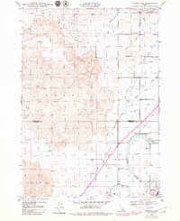
1959 Map of Woodville
USGS Topo · Published 1979About this map
Lava formations dominate the western landscape of this Idaho quadrangle, creating a stark contrast with the intensively irrigated agricultural lands to the east. The Lower Snake River serves as the primary artery for a complex network of waterways, including the Great Western Canal and Porter Canal, which dictate the local settlement patterns. The community of Woodville is centered near the Woodville Cem, while the town of Shelley sits further south along the river. This 1959 survey, updated with 1970s revisions, illustrates the engineering required to transform the arid Snake River Plain into productive farmland. Traceable features include the Shelley Bridge, various water control points like the Gaging Sta, and numerous irrigation branches such as the Bain Canal and Hodges Ditch.
Find a feature on this map
25 named features on this map. Tap any name to fly to it.
Don’t see what you’re looking for? This feature index may not catch every label — zoom into the map to look around manually.
Map Details
Editions of this 1959 Woodville Map
This is the sole edition of this map. No revisions or reprints were ever made.
Other maps of this area

1948 · Woodville
USGS Topo · 1:24,000

1948 · Idaho Falls North
USGS Topo · 1:24,000

1948 · Idaho Falls South
USGS Topo · 1:24,000

1949 · Idaho Falls North
USGS Topo · 1:24,000

1949 · Roberts
USGS Topo · 1:62,500

1949 · Shattuck Butte
USGS Topo · 1:24,000

1950 · Shattuck Butte
USGS Topo · 1:24,000

1950 · Woodville
USGS Topo · 1:24,000

1950 · Idaho Falls South
USGS Topo · 1:24,000

1950 · Goshen
USGS Topo · 1:24,000