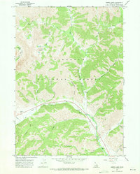
1967 Map of Amber Lakes
USGS Topo · Published 1971About this map
Amber Lakes and the high basins of the Sawtooth National Forest dominate this 1967 field-checked survey. The landscape is defined by the drainage systems of the Big Wood River and its various tributaries, including the North Fork Big Wood River and East Fork. The map records a transition in land use, showing established recreational sites such as Camp Manapu, Sawtooth Camp, and Wood River Campground nestled along the river valleys. A network of Pack Trails and Jeep Trails provides the primary access to higher elevations like Boulder Basin and Phantom Hill. These trails follow narrow drainages like Amber Gulch and Kendall Gulch, tracing the routes used by early travelers through the Idaho backcountry before modern infrastructure altered these corridors.
Find a feature on this map
33 named features on this map. Tap any name to fly to it.
Don’t see what you’re looking for? This feature index may not catch every label — zoom into the map to look around manually.
Map Details
Editions of this 1967 Amber Lakes Map
2 editions found
Other maps of this area

1895 · Hailey
USGS Topo · 1:125,000

1897 · Hailey
USGS Topo · 1:125,000

1900 · Sawtooth
USGS Topo · 1:125,000

1955 · Hailey
USGS Topo · 1:250,000

1959 · Hailey
USGS Topo · 1:250,000

1962 · Hailey
USGS Topo · 1:250,000
1967 · Meridian Peak
USGS Topo · 1:24,000

1967 · Rock Roll Canyon
USGS Topo · 1:24,000

1967 · Sun Valley
USGS Topo · 1:24,000
1967 · Griffin Butte
USGS Topo · 1:24,000