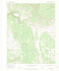
1967 Map of Hotchkiss Reservoir
USGS Topo · Published 1971About this map
Uncompahgre National Forest dominates this high-altitude landscape, where a sophisticated network of small-scale water management supported mid-century high-country activities. The map reveals a high density of specialized camps such as P D C Camp, Galloway Camp, and Jutten Camp, likely serving seasonal workers or grazing operations across the San Miguel and Montrose County lines. This hydrological infrastructure is particularly dense, featuring numerous named reservoirs like Hotchkiss Reservoir, Barnes Mill Reservoir, and Tikka Reservoir along with family-named sources such as Edmondson Spring and Turkey Plot Spring. The presence of the Horsefly Trail and various unpaved roads through Coyote Knob indicates a region defined by its reliance on forestry and livestock movement during the late 1960s.
Find a feature on this map
51 named features on this map. Tap any name to fly to it.
Don’t see what you’re looking for? This feature index may not catch every label — zoom into the map to look around manually.
Map Details
Editions of this 1967 Hotchkiss Reservoir Map
3 editions found
Other maps of this area

1909 · Montrose
USGS Topo · 1:125,000

1911 · Montrose
USGS Topo · 1:125,000

1953 · Placerville
USGS Topo · 1:24,000

1956 · Montrose
USGS Topo · 1:250,000

1956 · Moab
USGS Topo · 1:250,000

1959 · Moab
USGS Topo · 1:250,000

1959 · Montrose
USGS Topo · 1:250,000

1960 · Montrose
USGS Topo · 1:250,000

1960 · Moab
USGS Topo · 1:250,000

1962 · Moab
USGS Topo · 1:250,000