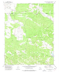
1972 Map of Water Canyon Peak
USGS Topo · Published 1977About this map
Dixie National Forest covers the high-elevation terrain of southwestern Utah, where the border between Iron and Washington counties meets. The landscape is defined by its extensive drainage systems, with Water Canyon and Green Canyon carved into the central highlands below Water Canyon Peak. Notable landmarks such as Rock Hole Corral and Terry Spring suggest a history of seasonal ranching and livestock management within these forest lands. In the southeast corner, the Upper Enterprise Reservoir serves as a critical water resource, collecting flow from Shoal Creek and Willow Spring Draw. This 1970s survey captures a network of specialized routes, including the Rock Pack Trail and several Pack Trails and Jeep tracks that provided access through West Pass and across Big Bench for land managers and outdoorsmen alike.
Find a feature on this map
36 named features on this map. Tap any name to fly to it.
Don’t see what you’re looking for? This feature index may not catch every label — zoom into the map to look around manually.
Map Details
Editions of this 1972 Water Canyon Peak Map
This is the sole edition of this map. No revisions or reprints were ever made.
Other maps of this area

1885 · St. George
USGS Topo · 1:250,000

1885 · Pioche
USGS Topo · 1:250,000

1886 · Pioche
USGS Topo · 1:250,000

1891 · St. George
USGS Topo · 1:250,000

1953 · Cedar City
USGS Topo · 1:250,000

1954 · Caliente
USGS Topo · 1:250,000

1958 · Cedar City
USGS Topo · 1:250,000

1958 · Docs Pass
USGS Topo · 1:24,000

1959 · Caliente
USGS Topo · 1:250,000

1962 · Cedar City
USGS Topo · 1:250,000