
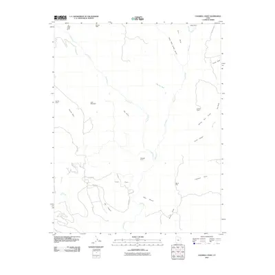
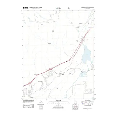
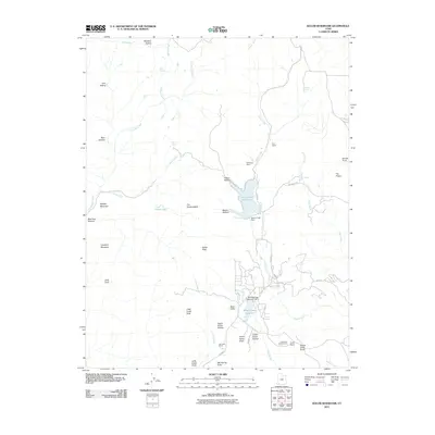
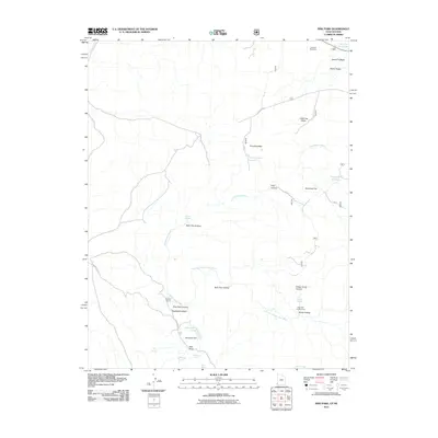
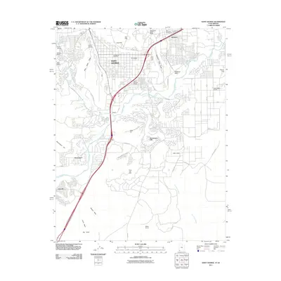
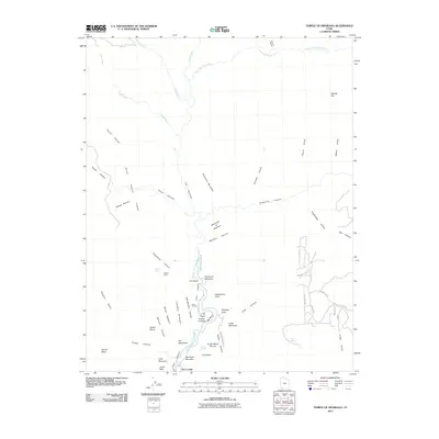
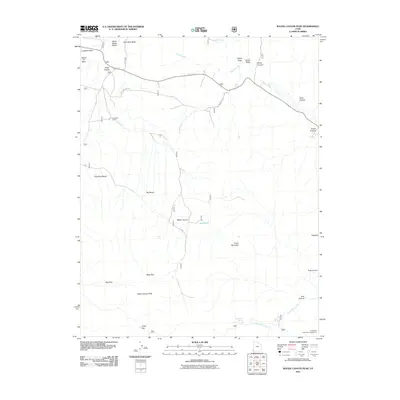
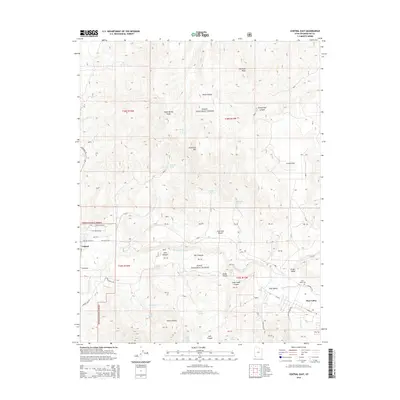
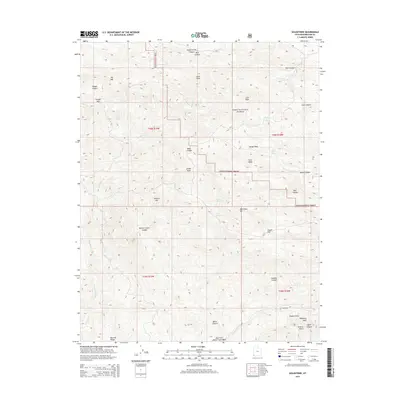
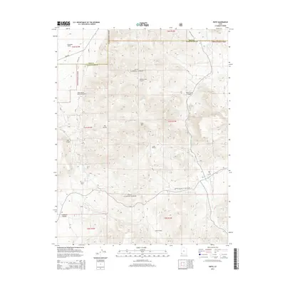
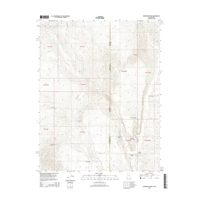
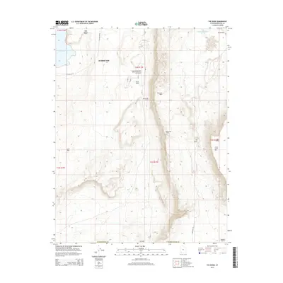
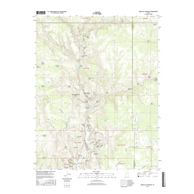
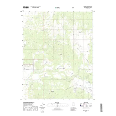
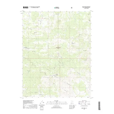
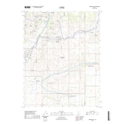
2002 Map of Water Canyon
USGS Topo · Published 2005About this map
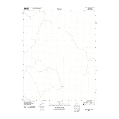
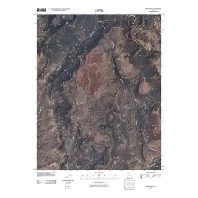
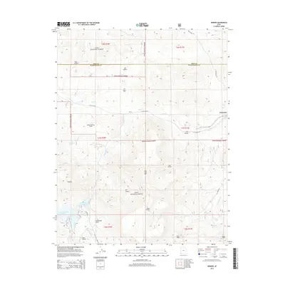
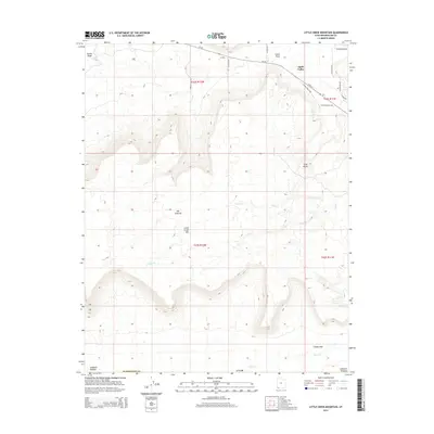
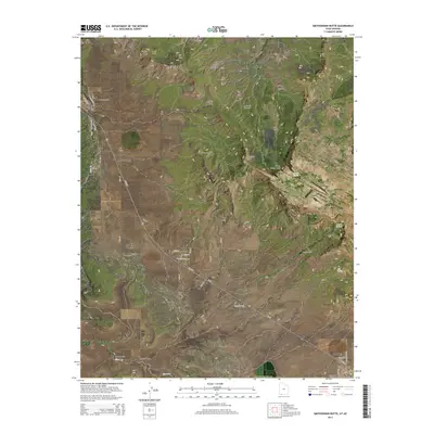
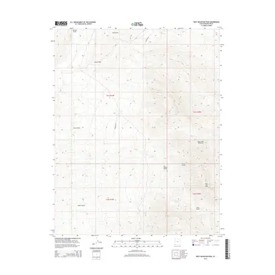
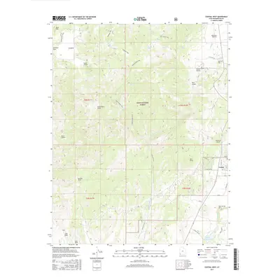
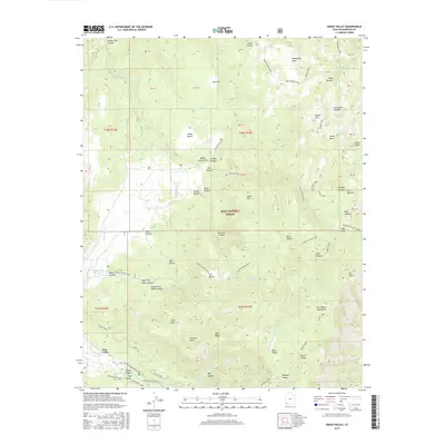
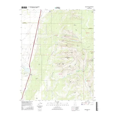
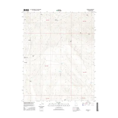
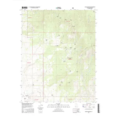
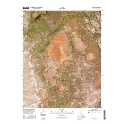
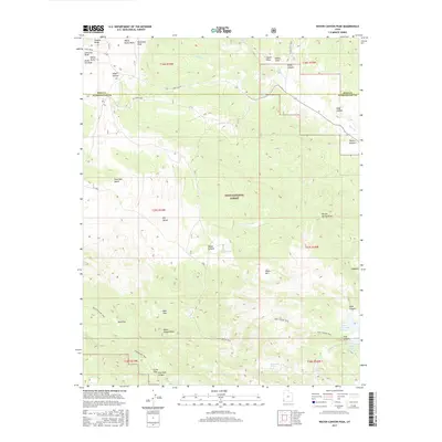
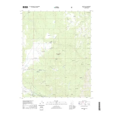
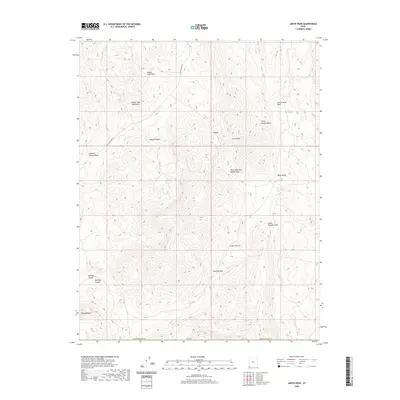
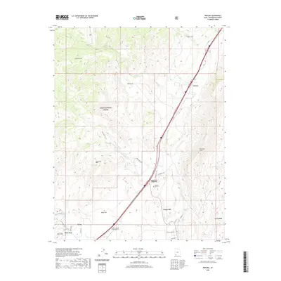
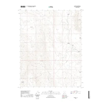
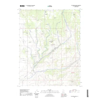
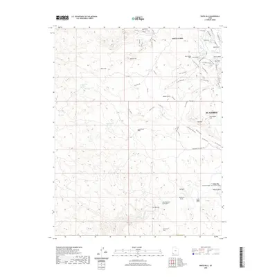
The high-desert terrain of the Dixie National Forest dominates this landscape, where the administrative boundary of the Pine Valley Ranger District meets the county line between Iron and Washington Counties. Natural water sources are critical features of this environment, with remote points like Nephi Spring, Terry Spring, and the curiously named Corral Dads Spring dotting the drainages. The map reveals a land utilized for cattle and transit, evidenced by the Rock Hole Corral and numerous 4wd tracks that negotiate the breaks between Panaca Ridge and Green Mountain. To the southeast, the Upper Enterprise Reservoir provides a substantial catchment at the terminus of Pine Canyon, while the prominent Water Canyon Peak serves as a primary landmark above the surrounding flats and hollows.
Find a feature on this map
30 named features on this map. Tap any name to fly to it.
Don’t see what you’re looking for? This feature index may not catch every label — zoom into the map to look around manually.
Map Details
Editions of this 2002 Water Canyon Map
This is the sole edition of this map. No revisions or reprints were ever made.
Historical Maps of Washington County Through Time
243 maps found

1954 Beaver Dam Mts NE
Washington County, UT

1954 Beaver Dam Mts SE
Washington County, UT

1954 Gunlock
Washington County, UT

1954 La Verkin 1 SW
Washington County, UT

1954 La Verkin 2 SE
Washington County, UT

1954 La Verkin 3 NE
Washington County, UT

1954 La Verkin 3 NW
Washington County, UT

1954 La Verkin 3 SE
Washington County, UT

1954 La Verkin 3 SW
Washington County, UT

1954 La Verkin 4 NW
Washington County, UT

1954 La Verkin 4 SE
Washington County, UT

1954 La Verkin 4 SW
Washington County, UT

1954 Orderville Canyon NW
Washington County, UT

1956 Springdale SW
Washington County, UT

1956 St. George NE
Washington County, UT

1956 St. George NW
Washington County, UT

1956 St. George SE
Washington County, UT

1956 St. George SW
Washington County, UT

1972 Central East
Washington County, UT

1972 Central West
Washington County, UT

1972 Goldstrike
Washington County, UT

1972 Gunlock
Washington County, UT

1972 Hebron
Washington County, UT

1972 Maple Ridge
Washington County, UT

1972 Motoqua
Washington County, UT

1972 Pinto
Washington County, UT

1972 Saddle Mountain
Washington County, UT

1972 Water Canyon Peak
Washington County, UT

1973 Dodge Spring
Washington County, UT

1973 Scarecrow Peak
Washington County, UT

1980 Cogswell Point
Washington County, UT

1980 Kolob Arch
Washington County, UT

1980 Kolob Reservoir
Washington County, UT

1980 Little Creek Mountain
Washington County, UT

1980 Smith Mesa
Washington County, UT

1980 Smithsonian Butte
Washington County, UT

1980 Springdale East
Washington County, UT

1980 Springdale West
Washington County, UT

1980 Temple of Sinawava
Washington County, UT

1980 The Guardian Angels
Washington County, UT

1983 Castle Cliff
Washington County, UT

1983 Jarvis Peak
Washington County, UT

1983 Shivwits
Washington County, UT

1983 West Mountain Peak
Washington County, UT

1986 Grass Valley
Washington County, UT

1986 Harrisburg Junction
Washington County, UT

1986 Pintura
Washington County, UT

1986 Signal Peak
Washington County, UT

1986 The Divide
Washington County, UT

1986 Washington Dome
Washington County, UT

1986 White Hills
Washington County, UT

1996 The Guardian Angels
Washington County, UT

1997 Springdale East
Washington County, UT

1997 Temple of Sinawava
Washington County, UT

1999 Springdale West
Washington County, UT

2002 Central East
Washington County, UT

2002 Central West
Washington County, UT

2002 Goldstrike
Washington County, UT

2002 Grass Valley
Washington County, UT

2002 Gunlock
Washington County, UT

2002 Hebron
Washington County, UT

2002 Maple Ridge
Washington County, UT

2002 Pine Park
Washington County, UT

2002 Pinto
Washington County, UT

2002 Pintura
Washington County, UT

2002 Saddle Mountain
Washington County, UT

2002 Signal Peak
Washington County, UT
2002 Water Canyon
Washington County, UT
2010 Cogswell Point
Washington County, UT
2011 Castle Cliff
Washington County, UT
2011 Central East
Washington County, UT
2011 Central West
Washington County, UT
2011 Dodge Spring
Washington County, UT
2011 Goldstrike
Washington County, UT
2011 Grass Valley
Washington County, UT
2011 Gunlock
Washington County, UT
2011 Harrisburg Junction
Washington County, UT
2011 Hebron
Washington County, UT
2011 Jarvis Peak
Washington County, UT
2011 Kolob Arch
Washington County, UT
2011 Kolob Reservoir
Washington County, UT
2011 Little Creek Mountain
Washington County, UT
2011 Maple Ridge
Washington County, UT
2011 Motoqua
Washington County, UT
2011 Pine Park
Washington County, UT
2011 Pinto
Washington County, UT
2011 Pintura
Washington County, UT
2011 Saddle Mountain
Washington County, UT
2011 Saint George
Washington County, UT
2011 Scarecrow Peak
Washington County, UT
2011 Shivwits
Washington County, UT
2011 Signal Peak
Washington County, UT
2011 Smith Mesa
Washington County, UT
2011 Smithsonian Butte
Washington County, UT
2011 Springdale East
Washington County, UT
2011 Springdale West
Washington County, UT
2011 Temple of Sinawava
Washington County, UT
2011 The Divide
Washington County, UT
2011 The Guardian Angels
Washington County, UT
2011 Washington Dome
Washington County, UT
2011 Water Canyon Peak
Washington County, UT
2011 West Mountain Peak
Washington County, UT
2011 White Hills
Washington County, UT
2014 Castle Cliff
Washington County, UT
2014 Central East
Washington County, UT
2014 Central West
Washington County, UT
2014 Cogswell Point
Washington County, UT
2014 Dodge Spring
Washington County, UT
2014 Goldstrike
Washington County, UT
2014 Grass Valley
Washington County, UT
2014 Gunlock
Washington County, UT
2014 Harrisburg Junction
Washington County, UT
2014 Hebron
Washington County, UT
2014 Jarvis Peak
Washington County, UT
2014 Kolob Arch
Washington County, UT
2014 Kolob Reservoir
Washington County, UT
2014 Little Creek Mountain
Washington County, UT
2014 Maple Ridge
Washington County, UT
2014 Motoqua
Washington County, UT
2014 Pine Park
Washington County, UT
2014 Pinto
Washington County, UT
2014 Pintura
Washington County, UT
2014 Saddle Mountain
Washington County, UT
2014 Saint George
Washington County, UT
2014 Scarecrow Peak
Washington County, UT
2014 Shivwits
Washington County, UT
2014 Signal Peak
Washington County, UT
2014 Smith Mesa
Washington County, UT
2014 Smithsonian Butte
Washington County, UT
2014 Springdale East
Washington County, UT
2014 Springdale West
Washington County, UT
2014 Temple of Sinawava
Washington County, UT
2014 The Divide
Washington County, UT
2014 The Guardian Angels
Washington County, UT
2014 Washington Dome
Washington County, UT
2014 Water Canyon Peak
Washington County, UT
2014 West Mountain Peak
Washington County, UT
2014 White Hills
Washington County, UT
2017 Castle Cliff
Washington County, UT
2017 Central East
Washington County, UT
2017 Central West
Washington County, UT
2017 Cogswell Point
Washington County, UT
2017 Dodge Spring
Washington County, UT
2017 Goldstrike
Washington County, UT
2017 Grass Valley
Washington County, UT

2017 Gunlock
Washington County, UT
2017 Harrisburg Junction
Washington County, UT
2017 Hebron
Washington County, UT
2017 Jarvis Peak
Washington County, UT
2017 Kolob Arch
Washington County, UT
2017 Kolob Reservoir
Washington County, UT
2017 Little Creek Mountain
Washington County, UT
2017 Maple Ridge
Washington County, UT
2017 Motoqua
Washington County, UT
2017 Pine Park
Washington County, UT
2017 Pinto
Washington County, UT
2017 Pintura
Washington County, UT
2017 Saddle Mountain
Washington County, UT

2017 Saint George
Washington County, UT
2017 Scarecrow Peak
Washington County, UT
2017 Shivwits
Washington County, UT
2017 Signal Peak
Washington County, UT
2017 Smith Mesa
Washington County, UT
2017 Smithsonian Butte
Washington County, UT
2017 Springdale East
Washington County, UT
2017 Springdale West
Washington County, UT
2017 Temple of Sinawava
Washington County, UT
2017 The Divide
Washington County, UT
2017 The Guardian Angels
Washington County, UT
2017 Washington Dome
Washington County, UT
2017 Water Canyon Peak
Washington County, UT
2017 West Mountain Peak
Washington County, UT
2017 White Hills
Washington County, UT
2020 Castle Cliff
Washington County, UT
2020 Central East
Washington County, UT
2020 Central West
Washington County, UT
2020 Cogswell Point
Washington County, UT
2020 Dodge Spring
Washington County, UT

2020 Goldstrike
Washington County, UT
2020 Grass Valley
Washington County, UT
2020 Gunlock
Washington County, UT
2020 Harrisburg Junction
Washington County, UT
2020 Hebron
Washington County, UT
2020 Jarvis Peak
Washington County, UT
2020 Kolob Arch
Washington County, UT
2020 Kolob Reservoir
Washington County, UT
2020 Little Creek Mountain
Washington County, UT
2020 Maple Ridge
Washington County, UT
2020 Motoqua
Washington County, UT
2020 Pine Park
Washington County, UT
2020 Pinto
Washington County, UT
2020 Pintura
Washington County, UT
2020 Saddle Mountain
Washington County, UT
2020 Saint George
Washington County, UT
2020 Scarecrow Peak
Washington County, UT
2020 Shivwits
Washington County, UT
2020 Signal Peak
Washington County, UT
2020 Smith Mesa
Washington County, UT
2020 Smithsonian Butte
Washington County, UT
2020 Springdale East
Washington County, UT
2020 Springdale West
Washington County, UT
2020 Temple of Sinawava
Washington County, UT
2020 The Divide
Washington County, UT
2020 The Guardian Angels
Washington County, UT
2020 Washington Dome
Washington County, UT
2020 Water Canyon Peak
Washington County, UT
2020 West Mountain Peak
Washington County, UT
2020 White Hills
Washington County, UT

2023 Castle Cliff
Washington County, UT

2023 Central East
Washington County, UT

2023 Central West
Washington County, UT

2023 Cogswell Point
Washington County, UT

2023 Dodge Spring
Washington County, UT

2023 Goldstrike
Washington County, UT

2023 Grass Valley
Washington County, UT

2023 Gunlock
Washington County, UT

2023 Harrisburg Junction
Washington County, UT

2023 Hebron
Washington County, UT

2023 Jarvis Peak
Washington County, UT

2023 Kolob Arch
Washington County, UT

2023 Kolob Reservoir
Washington County, UT

2023 Little Creek Mountain
Washington County, UT

2023 Maple Ridge
Washington County, UT

2023 Motoqua
Washington County, UT

2023 Pine Park
Washington County, UT

2023 Pinto
Washington County, UT

2023 Pintura
Washington County, UT

2023 Saddle Mountain
Washington County, UT

2023 Saint George
Washington County, UT

2023 Scarecrow Peak
Washington County, UT

2023 Shivwits
Washington County, UT

2023 Signal Peak
Washington County, UT

2023 Smith Mesa
Washington County, UT

2023 Smithsonian Butte
Washington County, UT

2023 Springdale East
Washington County, UT

2023 Springdale West
Washington County, UT

2023 Temple of Sinawava
Washington County, UT

2023 The Divide
Washington County, UT

2023 The Guardian Angels
Washington County, UT

2023 Washington Dome
Washington County, UT

2023 Water Canyon Peak
Washington County, UT

2023 West Mountain Peak
Washington County, UT

2023 White Hills
Washington County, UT