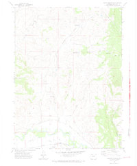
1971 Map of Hooker Mountain
USGS Topo · Published 1974About this map
The Yampa River corridor dominates the southern portion of this landscape, serving as a vital artery for irrigation and transport in Routt County. The winding river is paralleled by the Denver and Rio Grande Western railroad, which historically connected the region's agricultural and mining interests. An intricate network of water management features, including the Shelton Ditch, Walker Ditch, and Marshall Roberts Ditch, reflects the effort to redirect water from the river to the surrounding valley floor. To the north, the terrain rises toward the namesake Hooker Mountain, characterized by numerous gulches and small-scale water storage sites such as Shaefermeyer Reservoir No 1 and Morgan Creek Reservoir No 1. Significant elevation changes are marked by Morgan Creek Falls, while the southeastern corner shows early evidence of industrial activity with a labeled Strip Mine and Meadow Gulch.
Find a feature on this map
26 named features on this map. Tap any name to fly to it.
Don’t see what you’re looking for? This feature index may not catch every label — zoom into the map to look around manually.
Map Details
Editions of this 1971 Hooker Mountain Map
2 editions found
Other maps of this area

1916 · Daton Peak
USGS Topo · 1:62,500

1920 · Daton Peak
USGS Topo · 1:62,500

1923 · Elkhead Creek
USGS Topo · 1:62,500

1923 · Pilot Knob
USGS Topo · 1:62,500

1924 · Elkhead Creek
USGS Topo · 1:62,500

1924 · Mt. Harris
USGS Topo · 1:48,000

1925 · Pilot Knob
USGS Topo · 1:62,500

1926 · Mount Harris
USGS Topo · 1:62,500

1954 · Craig
USGS Topo · 1:250,000

1957 · Craig
USGS Topo · 1:250,000