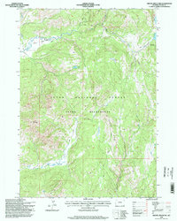
1996 Map of Gravel Mountain
USGS Topo · Published 1998About this map
The Teton Wilderness within the Teton National Forest is defined by its network of backcountry routes and significant elevation changes. Centered on Gravel Ridge and the prominent peak of Gravel Mountain, this 1990s-era topographic survey documents the hydrological divide where Pacific Creek and Enos Creek carve through the landscape. The remote character of the area is illustrated by the Enos Lake Patrol Cabin, a rare human marker in a territory primarily designated for non-motorized passage. A specialized trail system, including the Atlantic Pacific Trail and the Divide Trail, facilitates movement across high-altitude terrain, connecting isolated water bodies like Moss Lake with the southern drainages of Lava Creek and Randolph Creek near Mount Randolph.
Find a feature on this map
22 named features on this map. Tap any name to fly to it.
Don’t see what you’re looking for? This feature index may not catch every label — zoom into the map to look around manually.
Map Details
Editions of this 1996 Gravel Mountain Map
This is the sole edition of this map. No revisions or reprints were ever made.
Other maps of this area

1885 · Lake
USGS Topo · 1:125,000

1895 · Lake
USGS Topo · 1:125,000

1896 · Lake
USGS Topo · 1:125,000

1901 · Lake
USGS Topo · 1:125,000

1902 · Mt Leidy
USGS Topo · 1:125,000

1906 · Lake
USGS Topo · 1:125,000

1911 · Lake
USGS Topo · 1:125,000

1955 · Ashton
USGS Topo · 1:250,000

1955 · Driggs
USGS Topo · 1:250,000

1958 · Driggs
USGS Topo · 1:250,000