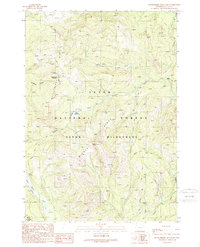
1989 Map of Huckleberry Mountain
USGS Topo · Published 1989About this map
Huckleberry Mountain and the high elevations of Huckleberry Ridge dominate this landscape, which transitioned into the protected Teton Wilderness by the late 1980s. The area is defined by a dense network of high-country drainage, where Rodent Creek and Whetstone Creek carve through the deep timber and open spaces of Brown Meadows. This survey records the primitive transportation network of the era, focusing on established backcountry routes such as the Sheffield Creek Trail and the Arizona Creek Trail. These paths provided essential access for forest management and wilderness recreation before the turn of the decade. The map also captures the northern boundary of Grand Teton National Park, showing the relationship between national forest lands and the expanded park system near Bailey Meadows.
Find a feature on this map
21 named features on this map. Tap any name to fly to it.
Don’t see what you’re looking for? This feature index may not catch every label — zoom into the map to look around manually.
Map Details
Editions of this 1989 Huckleberry Mountain Map
This is the sole edition of this map. No revisions or reprints were ever made.
Other maps of this area

1885 · Lake
USGS Topo · 1:125,000

1886 · Shoshone
USGS Topo · 1:125,000

1888 · Shoshone
USGS Topo · 1:125,000

1895 · Shoshone
USGS Topo · 1:125,000

1895 · Lake
USGS Topo · 1:125,000

1896 · Lake
USGS Topo · 1:125,000

1899 · Grand Teton
USGS Topo · 1:125,000

1901 · Shoshone
USGS Topo · 1:125,000

1901 · Lake
USGS Topo · 1:125,000

1901 · Grand Teton
USGS Topo · 1:125,000