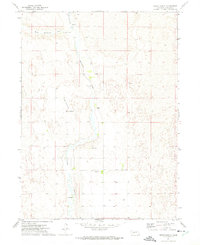
1972 Map of Green Ranch
USGS Topo · Published 1975About this map
Birdwood Creek and its western forks dominate this western Nebraska landscape, carving through the sand hills of Lincoln County. The map reveals a specialized ranching economy in the early 1970s, where large family operations like Richardson Ranch, Green Ranch, and Fleecs Ranch define the settlement pattern. Remote and largely roadless, the area relies on private infrastructure such as the Green Landing Strip and widely spaced wells. Educational needs for these isolated homesteads were served by the Birdwood School No 36, a vital local landmark for genealogists researching rural school districts. The terrain is characterized by complex contouring and numerous springs, such as the Spring near the confluence of N Fk Birdwood Cr, illustrating the vital water management required for high-plains cattle ranching.
Find a feature on this map
14 named features on this map. Tap any name to fly to it.
Don’t see what you’re looking for? This feature index may not catch every label — zoom into the map to look around manually.
Map Details
Editions of this 1972 Green Ranch Map
This is the sole edition of this map. No revisions or reprints were ever made.
Other maps of this area

1898 · Paxton
USGS Topo · 1:125,000

1899 · North Platte
USGS Topo · 1:125,000

1901 · Paxton
USGS Topo · 1:125,000

1902 · North Platte
USGS Topo · 1:125,000

1954 · North Platte
USGS Topo · 1:250,000

1956 · North Platte
USGS Topo · 1:250,000

1957 · North Platte
USGS Topo · 1:250,000

1967 · North Platte
USGS Topo · 1:250,000
1970 · Hershey East
USGS Topo · 1:24,000
1971 · Hershey West
USGS Topo · 1:24,000