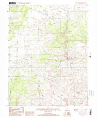
1988 Map of Horse Valley
USGS Topo · Published 1988About this map
Sinbad Country dominates the central landscape of this 1988 provisional survey, a region defined by complex drainage networks and expansive high flats. The topography is characterized by deep erosional cuts including Little Wild Horse Canyon, Cistern Canyon, and Bell Canyon, which all drain southward toward the larger Chute Canyon system. These dramatic vertical features contrast sharply with the broad, relatively level expanses of Taylor Flat in the northeast and McKay Flat in the west. The name patterns found here, such as Horse Valley and Bruff Valley, reflect the historical livestock and grazing heritage of Emery County. This map provides a technical view of the land as it was documented in the early 1980s, tracing the intricate draws like Baptist Draw and Little Ocean Draw that have shaped this portion of the San Rafael Swell.
Find a feature on this map
11 named features on this map. Tap any name to fly to it.
Don’t see what you’re looking for? This feature index may not catch every label — zoom into the map to look around manually.
Map Details
Editions of this 1988 Horse Valley Map
2 editions found
Other maps of this area

1885 · San Rafael
USGS Topo · 1:250,000

1952 · Wild Horse
USGS Topo · 1:62,500

1952 · San Rafael Knob
USGS Topo · 1:62,500

1953 · Stinking Spring Creek 2 SE
USGS Topo · 1:24,000

1953 · Temple Mtn
USGS Topo · 1:62,500

1954 · Stinking Springs Creek 4 SW
USGS Topo · 1:24,000

1954 · Stinking Spring Creek 3 NW
USGS Topo · 1:24,000

1954 · Stinking Spring Creek 3 SE
USGS Topo · 1:24,000

1954 · Stinking Spring Creek 4 NW
USGS Topo · 1:24,000

1954 · Stinking Spring Creek 2 SW
USGS Topo · 1:24,000