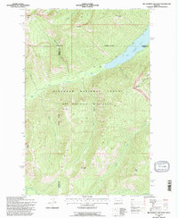
1994 Map of Big Salmon Lake West
USGS Topo · Published 1997About this map
Big Salmon Lake dominates this mid-1990s terrain, marking a boundary where the Flathead National Forest meets the Bob Marshall Wilderness. This area is characterized by significant topographic relief, anchored by summits such as Garnet Peak, Charlotte Peak, and Flame Peak. The landscape is intricately carved by numerous drainages, including Casey Creek, Holbrook Creek, and Charlotte Creek, all feeding toward the central waterway. Local human history is represented by the remote Pendant Cabin along the banks of Big Salmon Creek near the southern quadrangle edge. These labels reflect a wilderness area managed for preservation, where named points like Patrol Point and Gyp Mtn suggest a history of fire lookout or geological survey activity. The presence of Barrier Falls on Big Salmon Creek illustrates the natural obstacles inherent to this mountain drainage system.
Find a feature on this map
28 named features on this map. Tap any name to fly to it.
Don’t see what you’re looking for? This feature index may not catch every label — zoom into the map to look around manually.
Map Details
Editions of this 1994 Big Salmon Lake West Map
This is the sole edition of this map. No revisions or reprints were ever made.
Other maps of this area

1902 · Ovando
USGS Topo · 1:125,000

1905 · Ovando
USGS Topo · 1:125,000

1921 · Elbow Lake
USGS Topo · 1:125,000

1936 · Silvertip
USGS Topo · 1:96,000

1942 · Silvertip
USGS Topo · 1:125,000

1955 · Choteau
USGS Topo · 1:250,000

1957 · Choteau
USGS Topo · 1:250,000

1958 · Choteau
USGS Topo · 1:250,000

1962 · Choteau
USGS Topo · 1:250,000

1965 · Sunburst Lake
USGS Topo · 1:24,000