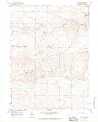
1963 Map of J H D Ranch
USGS Topo · Published 1967About this map
J H D Ranch and its network of satellite encampments define the ranching operations of Laramie County during the early 1960s. The landscape is marked by a complex system of livestock infrastructure, with numerous seasonal or functional camps such as Upper JHD Camp, JHD Dry Camp, and Coyote Mill Camp scattered across the drainages. Water management is central to the area's survival, evidenced by the J H D Supply Ditch diverting from Horse Creek and the lone Tinker Windmill providing a vital point of relief in the drier sections. The topography transitions from the high ground of Indian Hill down through Chivington Draw, while a series of unimproved paths and the Trail Creek Road connect remote outposts like Luey Huey Camp and Prong Horn Camp to the main ranch headquarters.
Find a feature on this map
29 named features on this map. Tap any name to fly to it.
Don’t see what you’re looking for? This feature index may not catch every label — zoom into the map to look around manually.
Map Details
Editions of this 1963 J H D Ranch Map
This is the sole edition of this map. No revisions or reprints were ever made.
Other maps of this area

1911 · Cheyenne
USGS Topo · 1:125,000

1914 · Cheyenne
USGS Topo · 1:125,000

1954 · Cheyenne
USGS Topo · 1:250,000

1958 · Cheyenne
USGS Topo · 1:250,000

1962 · P O Ranch
USGS Topo · 1:24,000

1962 · Moffett Ranch
USGS Topo · 1:24,000

1962 · Lewis Ranch
USGS Topo · 1:24,000

1963 · Little Indian Draw
USGS Topo · 1:24,000

1963 · Pole Creek Ranch SE
USGS Topo · 1:24,000
1963 · Pole Creek Ranch
USGS Topo · 1:24,000