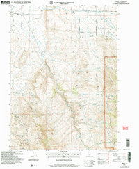
2001 Map of Basin
USGS Topo · Published 2006About this map
Oakley and Basin anchor the landscape of Cassia County, Idaho, in this revision reflecting conditions at the turn of the 21st century. The map details an environment defined by the transition from settled agricultural grid-lines to the complex drainage systems of Middle Mountain. Water management is prominent throughout the terrain, from the Aqueduct and Canal systems near Oakley to the natural flow of Bitch Creek and Mill Creek. The eastern portion is dominated by the Sawtooth National Forest, where the topography rises sharply toward features like Camel Rock. Economic activity is evident in the numerous resource extraction sites scattered across the hills, including the Fish Creek Quarry and several other Quarries and Prospect sites. Local history and genealogy are preserved through the identification of the Basin Cem and the smaller Cem near the township lines, marking early settlement patterns in this part of Southern Idaho.
Find a feature on this map
29 named features on this map. Tap any name to fly to it.
Don’t see what you’re looking for? This feature index may not catch every label — zoom into the map to look around manually.
Map Details
Editions of this 2001 Basin Map
This is the sole edition of this map. No revisions or reprints were ever made.
Other maps of this area

1954 · Pocatello
USGS Topo · 1:250,000

1958 · Pocatello
USGS Topo · 1:250,000

1968 · Almo
USGS Topo · 1:24,000

1968 · Cache Peak
USGS Topo · 1:24,000

1968 · Basin
USGS Topo · 1:24,000
1968 · Blue Hill
USGS Topo · 1:24,000

1968 · Marion SE
USGS Topo · 1:24,000
1968 · Oakley
USGS Topo · 1:24,000

1968 · Mount Harrison
USGS Topo · 1:24,000

1968 · Lyman Pass
USGS Topo · 1:24,000