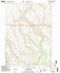
2001 Map of Rams Horn Ridge
USGS Topo · Published 2006About this map
Rams Horn Ridge serves as the central spine for this high-elevation landscape within the Sawtooth National Forest. The map documents a rugged drainage network defined by the East Fork Dry Creek and Middle Fork Dry Creek, where seasonal hydrology is supported by numerous named seeps such as Coyote Spring and Bowers Spring. The human footprint is sparse, primarily represented by isolated points like Mikes Cabin and a Corral, suggesting a history of seasonal ranching or forest management.
Find a feature on this map
35 named features on this map. Tap any name to fly to it.
Don’t see what you’re looking for? This feature index may not catch every label — zoom into the map to look around manually.
Map Details
Editions of this 2001 Rams Horn Ridge Map
This is the sole edition of this map. No revisions or reprints were ever made.
Other maps of this area

1955 · Twin Falls
USGS Topo · 1:250,000

1958 · Twin Falls
USGS Topo · 1:250,000

1965 · Rams Horn Ridge
USGS Topo · 1:24,000

1965 · Milner Butte
USGS Topo · 1:24,000

1965 · Stricker Butte
USGS Topo · 1:24,000

1965 · Grand View Peak
USGS Topo · 1:24,000

1965 · Murtaugh
USGS Topo · 1:24,000

1965 · Buckhorn Canyon
USGS Topo · 1:24,000
1978 · Pike Mountain
USGS Topo · 1:24,000
1978 · Severe Spring
USGS Topo · 1:24,000