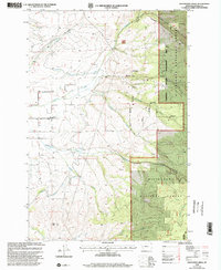
1998 Map of Grayhorse Creek
USGS Topo · Published 2002About this map
Bitterroot Irrigation District Canal winds through the lower elevations of this Ravalli County landscape, illustrating the critical role of water management in Montana's agricultural development. The terrain is defined by a series of drainages, including Threemile Creek, Ambrose Creek, and Grayhorse Creek, which flow westward from the high timber of the Bitterroot National Forest. Human presence is anchored by the Lone Rock Sch and a local Cem, alongside scattered extraction sites like a Gravel Pit and several Prospect locations.
Find a feature on this map
18 named features on this map. Tap any name to fly to it.
Don’t see what you’re looking for? This feature index may not catch every label — zoom into the map to look around manually.
Map Details
Editions of this 1998 Grayhorse Creek Map
This is the sole edition of this map. No revisions or reprints were ever made.
Other maps of this area

1901 · Hamilton
USGS Topo · 1:125,000

1903 · Bonner
USGS Topo · 1:125,000

1909 · Sapphire
USGS Topo · 1:125,000

1912 · Missoula
USGS Topo · 1:125,000

1947 · Butte
USGS Topo · 1:250,000

1956 · Hamilton
USGS Topo · 1:250,000

1958 · Butte
USGS Topo · 1:250,000

1959 · Hamilton
USGS Topo · 1:250,000

1959 · Cleveland Mountain
USGS Topo · 1:62,500

1960 · Butte
USGS Topo · 1:250,000