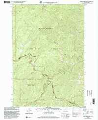
1998 Map of Horse Creek Pass
USGS Topo · Published 2002About this map
Bitterroot National Forest and the Salmon National Forest meet at the crest of the Bitterroot Range, marking the high-altitude boundary between Ravalli County, Montana, and Lemhi County, Idaho. This late-twentieth-century landscape is defined by its dramatic drainage networks, where the headwaters of North Fork Deer Creek and Chicken Creek flow through steep terrain north of the divide. To the south, the map captures the northern reaches of the Frank Church River of No Return Wilderness, a protected expanse where Horse Creek and Saddle Creek begin their descent toward the Salmon River. Human activity is concentrated around strategic transit points and recreation sites, most notably the Horse Creek Hot Springs Campground near the southern edge of the sheet. Higher up, Horse Creek Pass and Woods Creek Pass serve as the primary topographic breaches in the ridgeline, while prominent landmarks like Razorback Mountain and Cathedral Rock provide orientation for those navigating this montane environment.
Find a feature on this map
26 named features on this map. Tap any name to fly to it.
Don’t see what you’re looking for? This feature index may not catch every label — zoom into the map to look around manually.
Map Details
Editions of this 1998 Horse Creek Pass Map
This is the sole edition of this map. No revisions or reprints were ever made.
Other maps of this area

1956 · Elk City
USGS Topo · 1:250,000

1960 · Elk City
USGS Topo · 1:250,000

1960 · Painted Rocks Lake
USGS Topo · 1:62,500

1960 · Shoup
USGS Topo · 1:62,500

1962 · Blue Joint
USGS Topo · 1:24,000

1962 · Horse Creek Butte
USGS Topo · 1:24,000

1962 · Nez Perce Peak
USGS Topo · 1:24,000

1982 · Bighorn Crags
USGS Topo · 1:100,000

1991 · Horse Creek Pass
USGS Topo · 1:24,000
1991 · Tincup Hill
USGS Topo · 1:24,000