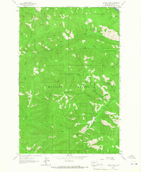
1964 Map of Diamond Point
USGS Topo · Published 1967About this map
The Lolo National Forest interior, documented in the early 1960s, is defined by an intricate network of drainages and mountain ridges within Missoula County. The Clark Fork cuts across the northern edge of the sheet, followed by the South Side Road, while the vast majority of the landscape remains a roadless territory of steep gulches and high points. Names like Wild Horse Point and Diamond Point indicate the prominent overlooks of this backcountry terrain.
Find a feature on this map
23 named features on this map. Tap any name to fly to it.
Don’t see what you’re looking for? This feature index may not catch every label — zoom into the map to look around manually.
Map Details
Editions of this 1964 Diamond Point Map
2 editions found
Other maps of this area

1912 · Missoula
USGS Topo · 1:125,000

1956 · Wallace
USGS Topo · 1:250,000

1956 · Hamilton
USGS Topo · 1:250,000

1959 · Hamilton
USGS Topo · 1:250,000

1959 · Alberton
USGS Topo · 1:62,500

1959 · Arlee
USGS Topo · 1:62,500

1960 · Wallace
USGS Topo · 1:250,000

1960 · Hamilton
USGS Topo · 1:250,000

1963 · Primrose
USGS Topo · 1:24,000

1964 · Hamilton
USGS Topo · 1:250,000