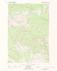
1988 Map of Gold Creek Peak
USGS Topo · Published 1988About this map
The Flathead Indian Reservation boundary cuts through this mountainous terrain, marking a distinct line between tribal lands and the Lolo National Forest. This 1988 revision, based on Bureau of Indian Affairs data, highlights a Tribal Primitive Area in the northwest, emphasizing a landscape managed for its natural state. The topography is dominated by significant elevations such as Gold Creek Peak and Black Mountain, with a network of drainages including Gold Creek and its West Fork. A network of Jeep Trails provides the primary access through the steep ridges, notably along Game Ridge and near Boles Point. The map serves as a record of land management and natural resource boundaries, capturing the intersection of indigenous territory and federal forest lands before modern digital mapping.
Find a feature on this map
16 named features on this map. Tap any name to fly to it.
Don’t see what you’re looking for? This feature index may not catch every label — zoom into the map to look around manually.
Map Details
Editions of this 1988 Gold Creek Peak Map
This is the sole edition of this map. No revisions or reprints were ever made.
Other maps of this area

1903 · Bonner
USGS Topo · 1:125,000

1921 · Elbow Lake
USGS Topo · 1:125,000

1947 · Butte
USGS Topo · 1:250,000

1955 · Choteau
USGS Topo · 1:250,000

1957 · Choteau
USGS Topo · 1:250,000

1958 · Butte
USGS Topo · 1:250,000

1958 · Choteau
USGS Topo · 1:250,000

1960 · Butte
USGS Topo · 1:250,000

1962 · Choteau
USGS Topo · 1:250,000

1962 · Butte
USGS Topo · 1:250,000