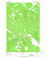
1965 Map of Sunflower Mountain
USGS Topo · Published 1967About this map
Lolo National Forest dominates this mid-1960s landscape, where the Blackfoot River carves a winding path through the mountainous terrain of Missoula County. The valley floor is defined by the infrastructure of the Chicago Milwaukee St Paul and Pacific railroad, which follows the river's northern bank past Johnsrud Park and through the bend at McNamara. The river itself is punctuated by named features like Rainbow Bend and Dungles Eddy, reflecting the area's importance for local recreation and transport. Higher elevations are marked by landmarks such as Sunflower Mountain and Kinneys Ridge, while the Gold Creek Guard Station signals the administrative presence of the Forest Service. The map reveals a remote but managed wilderness, with several Gravel Pit sites and forest roads like Union supporting the local timber and maintenance economies of the era.
Find a feature on this map
34 named features on this map. Tap any name to fly to it.
Don’t see what you’re looking for? This feature index may not catch every label — zoom into the map to look around manually.
Map Details
Editions of this 1965 Sunflower Mountain Map
This is the sole edition of this map. No revisions or reprints were ever made.
Other maps of this area

1903 · Bonner
USGS Topo · 1:125,000

1921 · Elbow Lake
USGS Topo · 1:125,000

1947 · Butte
USGS Topo · 1:250,000

1955 · Choteau
USGS Topo · 1:250,000

1957 · Choteau
USGS Topo · 1:250,000

1958 · Butte
USGS Topo · 1:250,000

1958 · Choteau
USGS Topo · 1:250,000

1960 · Butte
USGS Topo · 1:250,000

1962 · Choteau
USGS Topo · 1:250,000

1962 · Butte
USGS Topo · 1:250,000