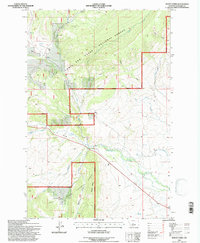
1995 Map of Mount Howe
USGS Topo · Published 1997About this map
Mount Howe stands as a prominent topographical anchor within the Musselshell Ranger District, overlooking a landscape defined by high-altitude drainages and early industrial markings. This portion of the Lewis and Clark National Forest shows the intersection of natural waterways like the North Fork Musselshell River and the South Fork Musselshell River with man-made infrastructure. Evidence of the region's mining and ranching history is present through labels such as the Cora Burton Mine, a generic mine near Cooks Flat, and the Mill Ditch. The terrain is deeply dissected by numerous gulches, including Pasture Gulch and Baxter Gulch, which channel seasonal runoff into the larger river systems. A network of unimproved roads and trails, such as Spring Creek, provides the primary access through these steep timbered slopes and open flats.
Find a feature on this map
24 named features on this map. Tap any name to fly to it.
Don’t see what you’re looking for? This feature index may not catch every label — zoom into the map to look around manually.
Map Details
Editions of this 1995 Mount Howe Map
This is the sole edition of this map. No revisions or reprints were ever made.
Other maps of this area

1886 · Little Belt Mts.
USGS Topo · 1:250,000

1894 · Little Belt Mts.
USGS Topo · 1:250,000

1897 · Little Belt Mts.
USGS Topo · 1:250,000

1898 · Little Belt Mts.
USGS Topo · 1:250,000

1902 · Little Belt Mts.
USGS Topo · 1:250,000

1948 · White Sulphur Springs
USGS Topo · 1:250,000

1958 · White Sulphur Springs
USGS Topo · 1:250,000

1961 · White Sulphur Springs
USGS Topo · 1:250,000

1965 · White Sulphur Springs
USGS Topo · 1:250,000
1972 · Daisy Peak
USGS Topo · 1:24,000