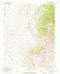
1969 Map of Holy Ghost Spring
USGS Topo · Published 1972About this map
Jemez Indian Reservation and Zia Indian Reservation converge in this high-desert landscape of Sandoval County, where the topography is defined by complex arroyo systems and the perennial flows of the Rio Puerco and Rio Salado. The presence of an Old Railroad Grade winding through the western portion of the map provides a tangible link to former industrial transport routes, while an Aqueduct and San Luis Tank near the southern boundary point to the essential water infrastructure of the era. Genealogists and local historians may find interest in the isolated Grave located north of the Holy Ghost Spring, a landmark which also lends its name to the nearby Holy Ghost Campground. The abundance of specialized water sources, including Soda Spring, Warm Springs, and the Chamisa Vega Falls Spring, highlights a landscape where mineral-rich water sources were central to the area's character and use.
Find a feature on this map
33 named features on this map. Tap any name to fly to it.
Don’t see what you’re looking for? This feature index may not catch every label — zoom into the map to look around manually.
Map Details
Editions of this 1969 Holy Ghost Spring Map
This is the sole edition of this map. No revisions or reprints were ever made.
Other maps of this area

1883 · Mt. Taylor
USGS Topo · 1:250,000

1886 · Mt. Taylor
USGS Topo · 1:250,000

1890 · Jemes
USGS Topo · 1:125,000

1892 · Jemes
USGS Topo · 1:125,000

1892 · Mt. Taylor
USGS Topo · 1:250,000

1899 · Mt. Taylor
USGS Topo · 1:250,000

1939 · La Ventana
USGS Topo · 1:62,500

1939 · San Ysidro
USGS Topo · 1:62,500

1943 · San Ysidro
USGS Topo · 1:62,500

1943 · La Ventana
USGS Topo · 1:62,500