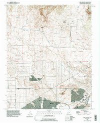
1990 Map of Loma Machete
USGS Topo · Published 1996About this map
Rio Rancho and the Town of Alameda serve as the primary anchors for this northern New Mexico landscape as it transitioned into the late twentieth century. While the lower elevations show the encroachment of planned street grids along Northern Blvd and Progress Blvd, the northern half remains defined by high desert terrain and drainage networks like the Arroyo Venado and Arroyo de Pantaleon. Landmarks such as Lincoln Middle Sch and local green spaces like Vista Hills Park mark the suburban expansion into the high mesas. To the northeast, the Santa Ana Indian Reservation boundary and the heights of Loma Barbon provide a stark contrast to the development below. The complex series of arroyos, including the Arroyo de las Calabacillas and Arroyo de las Lomitas Negras, underscores the significant role of natural drainage in shaping the road patterns and lot layouts for this expanding high-desert community.
Find a feature on this map
39 named features on this map. Tap any name to fly to it.
Don’t see what you’re looking for? This feature index may not catch every label — zoom into the map to look around manually.
Map Details
Editions of this 1990 Loma Machete Map
This is the sole edition of this map. No revisions or reprints were ever made.
Other maps of this area

1888 · Bernalillo
USGS Topo · 1:125,000

1889 · Albuquerque
USGS Topo · 1:125,000

1893 · Albuquerque
USGS Topo · 1:125,000

1934 · Alameda
USGS Topo · 1:24,000

1934 · Griegos
USGS Topo · 1:24,000

1938 · Albuquerque
USGS Topo · 1:62,500

1953 · Bernalillo NW
USGS Topo · 1:24,000

1954 · Alameda
USGS Topo · 1:24,000

1954 · Volcano Ranch
USGS Topo · 1:24,000

1954 · Loma Machete
USGS Topo · 1:24,000