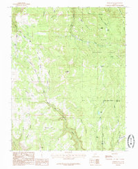
1985 Map of Webster Flat
USGS Topo · Published 1985About this map
Dixie National Forest defines the high-altitude landscape of this 1980s provisional survey, where the boundaries of Iron and Kane counties meet. The terrain is characterized by a series of prominent overlooks and family-named landmarks including Sherratt Point, Bauer Point, and O'Neil Point, which drop away into complex drainage systems like Steamboat Gulch and Everstein Hollow. Water sources are critical features of this high country, marked by numerous named springs such as Lundell Spring and Big Spring, along with Aspen Lake. The prominence of Miners Peak and the high plateau of Webster Flat indicate a landscape primarily used for seasonal grazing and resource management. The map's detail of various hollows, such as Ellies Canyon and Moats Hollow, provides an intricate look at the watershed patterns before more modern development reached these higher elevations.
Find a feature on this map
41 named features on this map. Tap any name to fly to it.
Don’t see what you’re looking for? This feature index may not catch every label — zoom into the map to look around manually.
Map Details
Editions of this 1985 Webster Flat Map
2 editions found
Other maps of this area

1885 · St. George
USGS Topo · 1:250,000

1886 · Kanab
USGS Topo · 1:250,000

1891 · St. George
USGS Topo · 1:250,000

1950 · Cedar City
USGS Topo · 1:24,000

1950 · Cedar City
USGS Topo · 1:62,500

1950 · Cedar Mountain
USGS Topo · 1:24,000

1952 · Cedar Mountain
USGS Topo · 1:24,000

1953 · Cedar City
USGS Topo · 1:250,000

1954 · Orderville Canyon NW
USGS Topo · 1:24,000

1957 · Orderville Canyon NE
USGS Topo · 1:24,000